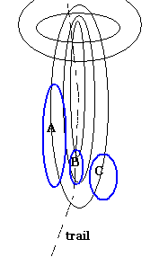
 Last time I was here I don't know what I was looking at. My companion spotted the first signs of rock piles and we went off to the left of the trail. I also remember seeing one or two things on the right of the trail (and thinking "I probably would have seen the piles myself in a moment"). But I have no idea how I missed some of the nice piles that are over on the right of the trail which I spotted last Sunday. Maybe there were more leaves on the trees the last time and the piles were not visible through the trees from the trail - and I never went enough off the trail at that point. Anyway, last Sunday when I looked around there were all kinds of piles to be seen. It was my impression that the piles on the left (at A on the sketch) were a typical hillside "marker pile" site, referenced to a visible major hill to the west - but done minimally with simple rock-on-rock rather than with larger more monumental piles. But this time I realized more explicitly that this part of the site was accompanied by another part (at B on the sketch) consisting of low ground piles; and that, finally, there was yet another part (at C on the sketch) where there were larger piles built on support boulders, at the edge of a wetland.
How, I wonder, could I have walked right by this one, ,which is ten feet from the trail (C on the map)?
 And these, that were further off to the side behind this first one.
 Here is the same group from further away. You can see the mountain laurel wetland beyond.
 These were just the nicest and most notable examples over on this side of the trail. There were a handful of others, not all on support boulders, but also made from large constituent rocks.
 The piles get smaller and with smaller contituent rocks as you go uphill, back towards the trail towards area B. This one, for example, is much more like a traditional marker pile but I don't know.
 The piles at B were mostly on the ground and well covered with dead leaves, providing slight excuse for walking past them without seeing them. I'll use another post to show pictures from A, and another trail-side pile that should have been noticed the first time.
There is a bit of organizational structure to this site. It is no more than 70 yards from one cluster of piles to the next (from A to C) and there is a distinct change in the style of piles from one place to another. I believe the western facing pile are more closely related to the view and that the eastern ones, at the edge of the wetland, and shown above, face the wetland for a different reason than the western ones face the sky.
2 comments :
Very n ice piles. Good pictures.
A forest road heading up hill to the north in Townsend State Forest.
Post a Comment