 None of these sites is fragile and, if they include burials, then the physical remnants have long since dissolved back into the soil. So there is a map. I won't discuss A (which I blogged here) or the un-labeled site at lower right. The site at B was shown to me on a field trip I took long ago with Norman Muller and Steve Ells. The site at C, at the headwaters of Dakins Brook, is new. It is rare to find a new site in my hometown and this is an interesting one.
Site B
Here are some pictures from the original visit to this site. That was April 2004. At the time all I could see about these 'mounds' was that they were on the brow of the hill, a sort of plateau looking southeast over Mink Pond. Situated that way, I thought these rock piles had an astronomical purpose.
I was thinking about this site recently. I tried and failed to locate it a couple of winters ago and was reminded of it when visiting site A with my wife a couple of weeks ago. I noticed a whole bit of the woods down west of the southern entrance, an area around "Farmer's Cliffs" on the map, that had not been explored recently. Anyway, remembering the site at B, looking over Mink Pond, I thought perhaps it was not astronomical but more consistent with the kind of rectangular burial mounds with inner chambers - that I call mounds with "hollows" under the heading "Wachusett Tradition". So I stayed to the left (along the road marked "Private") from the southern entrance and, in the end, circumnavigated the whole farm and field area, with a side trip up to see those remembered mounds.
At the northernmost end of the mown field, there is a swamp along the eastern edge, and there are a couple of rock piles in there (not indicated on the map fragment above) and one little "L" shaped corner of wall-like structure, right next to and opening towards the water. Take a look at that sometime. But when I got to the northernmost end of the mown field, I went around it and up to the brow of the hill/plateau there, thinking I would head north along the brow until I either saw the mounds or hit a trail that I knew I would have to cross. And I did come up to the first and then 2nd mound on the brow. They are very typical examples of rectangular mounds with hollows. Here is a first one:
 You can see the hollow on the interior of the pile, and get some sense of the vertical height of the remaining walls.
Here is a second one. From one end (essentially the same view as shown above for the first pile):
 From the other end:
 Here is a video, trying to convey the shape:
As I say: "in the end it is a rock pile with a tail...and a hollow".
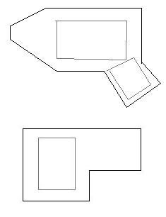
Here are an attempt at sketching the outlines of the two piles on the brow of the hill at B:
 These are slightly smaller than the examples from Fitchburg (see here and more generally here) but it is not too much of a stretch to see these are all part of a common culture. So the Wachusett Tradition is seen here in Concord too.
There is a third mound in this group, down next to the trail from Mink Pond that goes around the north end of the plateau. This mound is much larger and much more badly damaged.
 I could not make out much of the internal structure.
  These larger, longer mounds, are often seen at "Wachusett" sites. Following the archeology convention of wild guesses based on minimal data, let's just say that this hints at a hierarchical society, with special burials (the mounds higher on the hill) reserved for some individuals and a larger communal grave (at the foot of the hill) for others.
Site C
[...continued in next post...]
No comments :
Post a Comment