Saturday, May 31, 2008

Short stretches of wall at Mill Pond - Burlington, MA conservation land

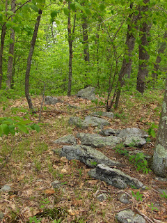
I mentioned locating several sites last weekend, most were un-exceptional but some of the things I saw in Burlington were a bit unusual. For example on the ridge looking southeast over the valley now filled with the "Mill Pond" (right hand red outline on the map fragment)were several short stretches of wall that started on top of the ridge and went 20 yards or so downhill towards the pond. These all more or less lined up in the same direction and I suspect were deliberately aligned in one particular direction.

Here is a first one:
Another view of the same short stretch, from below:A few hundred yards away was a different short stretch:Another view of the same, facing down towards the pond:And yet again a bit further along the ridge, here is what looks like a more primitive/decrepit and smaller version of the same type of thing:Next to it, the only rock pile I saw in this part of the conservation land:
There were a few other traces of things on the exposed bedrock on top. Like this propped slab:
In the end, although I thought the wildflower pictures were all that made the walk worthwhile, actually, there were quite a few remaining traces of ceremonialism.

Wednesday, May 28, 2008

Suburban MA Wildflowers - some with names some without

[Not rock pile related]

If you know the names of the un-identified flowers below, please comment:


These are from a wet area in Billerica

Fringed gaywings

A variety of violet

Starflower (thanks for the name JimP and Geophile)Wild geranium White Trillium (next to a split-wedged rock)

These are from a hilltop and power lines in Burlington


Field sow thistle (according to JimP) A pretty flower, perhaps a kind of bean (pale corydalis according to Geophile) Maybe a black rasberry? Forget-me-nots (correction from Geophile, they are bluets) Bush Honeysuckle some kind of wild cherry or apple
and of course, a Lady Slipper (from Groton)

A rock-on-rock by a cedar tree

Stow, MA

Woods near you

I have been using ACME topo maps [click here] and looking down into Weston and Wayland. Because I was not able to get the Framingham Quadrangle map hard copy, my knowledge and awareness of the woods down there is limited. So for example in this map:Shows several outlines in blue which are places I never explored. As for the red outlines, there was a large pile made of small cobbles and smeared out on the slopes south of the reservoir but I did not see anything south of Regis College. These places are a short drive from my house. Why didn't I notice them before?

Tuesday, May 27, 2008

More weekend days...more rock pile sites

I took last Friday off and had a 4 day Memorial Day weekend. Went out site hunting each day and was successful on 3 of the four days. The sites I found were not too exciting - decrepit, hidden, almost invisibile. I can barely remember what I found yesterday - oh yes, now I have it.

On Friday I explored a patch of woods in Billerica I have been saving since hunting season (I was too close to the gunfire last time). This time I found about 18 low ground piles - some with a white quartz rock at the center. A somewhat typical site.

On Saturday I went to "Mill Pond" a bit of Burlington Conservation Land. I walked around the woods (which are so used and urbanized that "park" is a more accurate term) for an hour or two and saw some interesting short stretches of stone wall coming off a high ridge and pointing out across the pond, eastward. I had pretty much given up on finding rock piles and then stumbled upon a confusing little site with more short wall stretches, some very beat-up piles, and a big hole in the ground like a sand and gravel borrow pit. Hard to figure if this was an obscure but practical land use or a ceremonial site.

On Sunday, I went with my wife to explore a conservation land in Groton, about which I have little good to say. Saw almost nothing worth reporting - except that strange rock-on-rock.

On Monday, Memorial Day, I went out to a hill in Stow I had never figured out how to get to. I had spotted a decent un-obtrusive parking place behind a commercial building. Went up and over. At one point there was a breakout zone with a few damaged piles and rock-on-rocks. Got a good workout.

I'll be posting pictures during the week.

Monday, May 26, 2008

Laughing Brook Redux

Geophile
More elements from Laughing Brook in Massachusetts. A huge split boulder with a tree where the wedge would be.
Here a wall goes over a split boulder.
Rocks on a rock, which is also on a rock.
Nice rock pile. There were many rock piles in one area, but most were not in good shape.
Rock on rock with a suggestion of ornithology.An interesting arrangement of rocks. The huge boulder in the background is the huge split one in the first picture. Most of the rock piles and rock-on-rocks were near there, although walls were common throughout the park.

A peculiar rock-on-rock

This is from a Groton Conservation Land, an otherwise dull bit of woods with quarried outcrops. This was along a faint brook:
Look at the closeup of this rock:
Talk about differntial weathering! Some readers will think this is manufactured. In any case, you can see why it caught someone's attention.

Saturday, May 24, 2008

Horned Serpent Petroglyph

Tim McSweeney sent me this link, to Kevin Callahan's Minnesota petroglyph web page:
If you scroll down you'll see a pretty clear representation of a horned serpent.

Hmm, the link stopped working. Here is an excerpt:
According to Tim's notes this creature was connected to healing.

Quarried Boulders and few rock piles - East Woods Boylston, MA

Just wanted to finish off surveying this part of the county and got access via an abandoned railroad track at the north end (the diagonal line below the USGS logo) and moseyed southwards. Saw lots of evidence of boulders having been broken up for quarrying purposes. Things like this:
I do not consider them to be rock piles of much interest when they are just examples of scattered debris. But I was having a little trouble dismissing some of them, that looked like a bit of work went into stacking them up:
But I did not see anything very convincing 'till I got down to the last outcrop before wetland. Here was a solitary rock pile, then a rock-on-rock, and then an interesting bit of stone wall following the edge of the outcrop:If you click on the picture, you might be able to see a little "key-hole"/window at the far right. Here it is in detail:I thought this was a little peculiar. The wall more or less ends here but starts again a little further along the outcrop, continues for a few yards and then turns downhill to the right, going down the "cliff" and stopping on its way into the wetter lower land at the edge of this outcrop. Meanwhile, on the southern side of the outcrop, just before the more open water, were the first signs of what I was sure were ceremonial structures. A rock-on-rock and a rock pile:
As I scanned around in the same area, I found another similar pile. The standing stone in the middle is obviously deliberate:Another view:Actually the neatest pile I saw was later after I had worked my way around to the east, looking west back over the same water. Here was a low curved pile.Another view:After that I headed east over the main hill and down to a little isolated pond, and then back north to my car. There might be more to see further south along the wet area but, in the direction I went, I saw little after this - an occasional rock-on-rock in the dappled light. A pleasant place to walk.

Thursday, May 22, 2008

Call me sentimental - pausing in East Woods

Boylston, MA:

Manitou stones in Holliston MA

A reader from Holliston writes in:
Now, those manitou stones: am I just seeing manitou in every triangular, upright stone I come across? Or, are there that many? I've probably seen over 100 both large and small that all end up pointing to something bigger and better or pointing in the direction of a possible pathway, or else I'm imagining things. I have included a photo at the top of this e-mail, I hope it comes through OK. It's a view of a tall, approximately 6 feet, triangular stone that sits just in front of two gargantuan boulders with many splits and cracks in them. My question, among a multitude of others, is, how can one tell the difference between colonial quarrying and Native American splits? does anyone know how they went about splitting rocks, or did they just find them that way, or move two stone close to each other?

Wednesday, May 21, 2008

Row piles and a small site - NY

by theseventhgeneration
I got out for a very quick hike this morning. The spot I went to started out, well, disappointing, considering I've been finding a lot of row piles with wood in them lately. Right as I got to the East/West edge of a hay field, a line of row piles lead away from the field in a North/South line. I didn't see any wood, at least, but they were close enough together to raise my suspicion that they were 'fence rail holders'. Here is the nicest pile in the row. It has a square rock visible in this photo and that rock has a red tinge to it.That row continued downhill until it came to a swamp, whereupon it changed from row piles to a stone wall. At that point, I went in the opposite direction, back to the hay field. Walking to the corner of the hay field and then continuing uphill in a North/South direction, there were more row piles, arguably field clearing. But I was still suspicious because sometimes they took the appearance of a stone wall and other times more like round stacked stone piles. And in another case, as in this photo, unusually large rocks grouped together and not quite in the row. You would think, if this is field clearing, the larger rocks would be closer to the edge of the field and not set back, as these were. Two of these also have a Manitou shape to them:Across the trail were some near grade level boulders in one spot. One of those boulders was a rock on rock:And the view from up there, by the way, was stunning. Just past the top corner of the hayfield, now getting close to 2000 feet in altitude, I continued on past where I could see any sign of obvious rock piles in a row, and then I saw a nice pile in the woods.There were two at this site that were large, well stacked, and not in a row. They also appeared to be 'piles on piles' with something like a larger base pile all around that didn't have obvious stacking, and then these nice piles stacked on top of that base. If you click on this photo, you might be able to make out that nice triangular rock at the top of the pile. The pile also had somewhat of a depression in it.
This next photo tries to capture a portion of the site. There were smaller row piles at the site that intersected the two larger piles.But the two larger piles were not in the row. I thought there were other small piles around that almost gave the sense of a grid, but I can't say for sure this was a grid. It started to rain and hail, so I started to leave. Walking back down along the North/South row of the hay field, I was a bit more encouraged that there is something more to these row piles than field clearing or fence rail supporting, so I looked a little closer and saw this sitting nicely on top of one of the piles:What a great ending to this hike!

Tuesday, May 20, 2008

FFC looks at the "Horned Creature" from Westford

I took FFC to see the rock pile I found a few weeks back.I pointed out the horned head and the quartz in the neck:FFC pointed out that the rock above the niche(lower left part of the pile) was a tail:
I payed more attention to a rock pile that sits a few feet behind the Horned Creature. Here is a view over the second pile back towards the first.
In detail this is also a bit like an effigy, with a head to the lower left:FFC said it looked like an eye but to me it looks like a smaller creature following the first horned one, there is a stunning piece of quartz in its belly:Cleaned:Pretty rich symbolism if it is not just my imagination.