These walls all were fragmentary, in short connected stretches but not forming corners. Here is a not very good or accurate diagram of the walls, but I hope it gives the idea.
 Here is a view of two nearby stretches of wall. Then details of each segment separately:
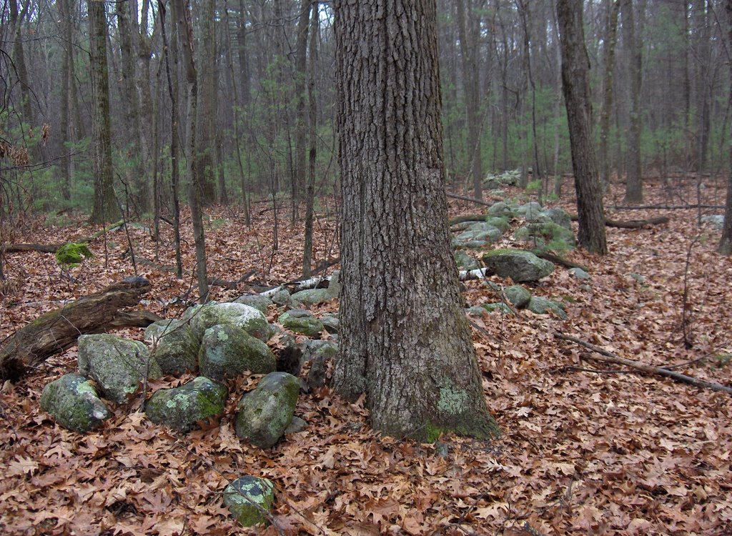
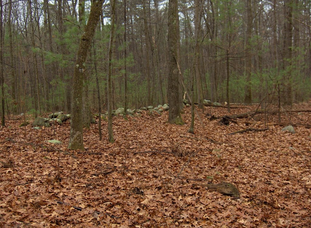
 There were two other stretches above the site, sort of the southeastern extremity of the rock pile area. So that means walls along the western and along the southeastern edge of the site..
  I am not prepared to classify this site. It seems more like a memorial site, with all the burnt rock in the piles. When I called FFC up to share my excitement about the site, and mentioned all the burnt rock, I mentioned ceremonial fires being built with rocks, and with the rocks later being incorporated into rock piles. And FFC brought up sweat lodges and the possibility that burnt rocks from the sweat lodge could have been used to make rock piles, as an extension of the activity. Also given the unusual wall stretches, I should get the compass boys out to make some measurements.
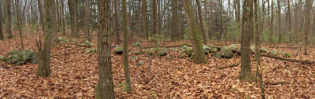
It is also noteworthy that this site is very similar to the XXX Hill site. It had at least one path running through the site and the path passes through a gap in the stretches of wall shown immediately above. Here is the trail as it passes the gap between two stretches of wall.
 This is virtually identical with the entrance to the XXX Hill site. As soon as you pass the wall the rock piles begin.
8 comments :
What are the physical characteristics of burnt rock? I've heated rock before, but except for charcoal residues on the exterior of the stone, I have not noticed any other change.
Around here rocks which have been in a fire and left outside, quickly develop an orange coating of iron oxide. I do not know the mechanism. You get a sense of it by looking at old fire ring stones, which are plentiful eg on Boyscout land. The inner surface of such rocks gets rust stained.
I know this is not factual and it is possible to mis-attribute rust stains to past heating. But it is a visual identification which "we" (me, Bruce McAleer, Tim Fohl, Jic Davis) all agree on and all use as a standard observation. Maybe it is incorrect sometimes but, for example, look at the coloration of the upper rocks on the pile 2nd from last in the article about Punkatasset rock piles. Note that the lower rocks in the pile do not have the orange stain.
Well allright! Some stone rows! With mounds inside them too!
I'd be tempted to surmise they were once connected in my firebreak theories, but the phrase "negative evidence' flashes before my eyes...
Looking at the map, I first wonder what Punkatasset means, see the sawmill brook and wonder where that was; were there once connected rows, were the missing stones harvested for something modern (what's the "monument" on the map - something made of stones?? Dams for the ponds?), easy paths to them, was logging going on and just question after question you might make educated guesses about what was going on here over time...
I don't see that it needs to be so complicated if the wall broken into segments is part of the site design. By comparing this site to one I found a few days later in Wayland, the layout of the walls seems similar enough to suggest it might be a design element of the sites. So I'll keep my eyes open.
According to the Massachusetts Indian Place Names book, Punkatasset refers to, "place of shallow pond." There is also some indication that it may refer to a spring.
You've got a point there; I shouldn't jump to conclusions especially when I've never been to the place.
I did a google search on Punkatasset/“Ponkawtasset” and found some old pictures: “Punkatasett Hill Photo Album
1906 Punkatasset -small The 1906 view from the top. Punkatasset used to be more open, with spacious views. Thoreau, Emerson, Channing, and their friends ...”
http://homepage.mac.com/sfe/henry/estabrook/album_punk.html
and even this long essay,something called “Henry Thoreau and the Estabrook Country: A Historic and Personal Landscape” by Stephen F. Ells.
Scrolling thru it I found: "“Another puzzle is just to the north of the quarries and between them and the Estabrook cellar hole: what are the rows of circles of pointed stones? Mary Fenn describes them as follows:
Then, crossing the stone-wall-enclosed field toward the Estabrook
cellar, we came upon a dozen or more stone circles [others have
counted thirty-three]—much in the nature of [generous] camp fires.
The stones were lichen covered, indicating they had been there for
many a year. As usual, no one in Concord except one man who owned
property in that area had ever seen them, and he had no idea what they
were for..."
Is this the place?
And is it more "Anybody but the Indians?"
Looking at the map I also wondered if there were cornfields in the flat lands east of the hill; in the essay I found this note (#19)
[19] Native Americans. (The citation is from F. B. Sanborn, The Life of Henry David Thoreau [Boston: Houghton Mifflin Co., 1917], 204.) Estabrook is laced with the hints of a Native American past. For example, the Concord Historical Commission says that a highly significant archeological area, dating from the Middle Archaic Period to Late Woodland (from 8000 to 350 years ago) is at Punkatasset Hill near Saw Mill Brook (in seventeenth century, Wigwam or Ralph's Brook) (Forman, Highlights, 89, 124 (map 1) and letter, Shirley Blancke to author, April 27, 1996). Thoreau found an adze there (IV:486, January 31, 1853) and farmer Daniel B. Clark, Jr., who farmed near the present Hutchins Pond, relates that on July 5-6, 1847, "Commenced haying. . . . Mowed over the indian hills on the side hill [east of the house]" (Clark, "Diary "). When asked about Native American artifacts, a family member told the author that jars were full of artifacts that had been picked up on the Lawrence lands, at the northeast edge of Estabrook Woods.
On a terrace above Bateman's Pond, which once may have been enriched by annual runs of shad and alewives (3:249, June 9, 1851), archaeologists found a black argillite Levanna point, which suggests a Late Woodland or Contact-era occupation. Beneath a unique colonial agricultural field there, the archaeologists found possible evidence of Native American corn hills. See end note on Rebecca Estabrook-Paul Adams place.
Thoreau spoke of an Indian campsite in Estabrook: "The Indian Rock . . . is upright, or overhanging two feet, and a dozen feet high. Against this the Indians camped" (X:18; August 29, 1857). Shirley Blancke was told by Gladys Clark of perhaps the last recorded Native American resident of Estabrook and of his campsite, though it is not clear that these locations are the same:
'A Native American farmhand worked intermittently for Thomas Tileston Davis and lived in a rock shelter in the woods south of Bateman's Pond, known locally as "Indian Rock." It is north of a path leading east from Lowell road. He is said to have left for good when angered by Davis's refusal to pierce his nose for him for a nose ring. (pers. comms., Shirley Blancke, April 27, October 18, 1996)'
Thomas Tileston Davis was born in 1823, son of Thos. H. Davis. The latter was, according to Thoreau's 1857 survey at the Concord Museum, a now-or-former owner of a parcel in the Bateman Wood-lots. See also the discussion of Bullocks wigwam and the corbeled stone chamber in endnote 8 on colonial history.
Yeah there is lots of good stuff in Concord. Apparently at one time you could not poke a stick into the ground and not find artifacts. They are few and far between today.
Post a Comment