 Bruce and I went out exploring Saturday with an eye to the intriguing looking wetlands west of Bayberry Hill. This is an area we had been planning to explore since mid-summer and so, Saturday, off we went. By the end of the day we had found four sites, and only scratched the surface of the woods along Wachusett Street, shown on the map fragment above. In the next few days I'll post photos and descriptions of these four sites and you can judge for yourself if they are similar to each other or reminiscent of other sites we have considered before. For my money the only site which seemed quite different from what I am used to was the one marked 3 in the above. I should also mention that we never did get to explore those intriguing wetlands, for the usual reason that mountain laurel prevented the possibility.
Since I already wrote these sites up for my Journal, I'll cut-and-paste from there. For starters, here are some introductory paragraphs:
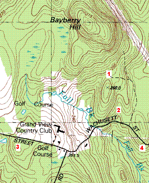
Sometime last summer, while we were looking at a map of Leominster State Forest, Bruce pointed out one the hills in Leominster, called Bayberry Hill, and he pointed out the nice swampy area west of the hill, and proposed going to check it out. All summer I explored to the north and to the south of Bayberry Hill, but I saved it for when we could go out together. Yesterday we did, and climbed the hill from the south via the dirt road shown as a dashed line on the map. As usual, movement was pretty restricted because of the mountain laurel but we found a small site (labeled with a 1 on the map fragment) at the col between the main hill and the smaller hill to the south. This was a place with water coming out of the ground in little puddles and with low ground piles and supported piles scattered about. There were perhaps 30 features. Also a nice view to the northeast and the southwest. After summiting the main hill, we did what we could to explore downhill to the west towards the verge of the wetlands but ended up not seeing anything and heading back to the car.
We decided to do a bit of driving west along Wachusett Street to watch for rock piles from the car - sort of like window shopping - and we had only gone a few yards when I thought I saw a rock-on-rock in the wetland to the right (labeled 2 on the map). We stopped and explored a bit and found a small site with pile right in the brook, leading uphill to a place which I judge to have been an old mill. After that we continued west and thought the tpography south of the road looked interesting, so we stopped and parked across from where the "Country Club" opening ended on the right, and walked south down into the woods (labeled 3 on the map). Here there was a slightly unusual site with deeply buried piles and what looked like small standing stones deliberate marking a direction in relation to the piles. After that, I was getting hungry and urged Bruce to head the car back in the direction we came from. We only just passed the first place we had parked when glancing downhill on the right, we both spotted some rock piles (at 4 on the map).
********************[continued in the next post]***********************
No comments :
Post a Comment