Tuesday, April 30, 2019
Saturday, April 27, 2019
Tuesday, April 23, 2019
Some Lines from a Hammonasset Story (Madison CT)
Sebaquanash “The Man Who Weeps” by Dale Carson (Abenaki)

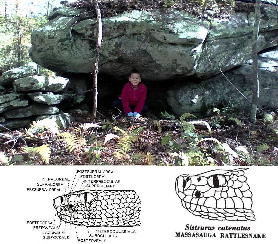
At Hammonassett, the beach was flat with occasional rock outcroppings for children and wildlife to discover. The salt marsh area where they lived in the summers was the most beautiful place one could imagine. Their wigwam was high enough to be safe from flooding and from every direction there was nothing but the glory that Creator had made. The morning sun to the east, the setting sun to the west and the moon rose and set over the land giving spectacular vistas all around. Indeed, a sacred place to live..."


In this surviving Hammonasset story, Mahomac says to his favorite grandson Sebaquanash: “Grandson, when I was not much older than you are now, I went to the caves north of here, our winter camp, and stayed alone without food for four days and nights. On the third night, I dreamt a strange and wondrous thing. The Great Spirit came to me and said that one day I would have a daughter who would give birth to a great leader of our people. He would be called “The Man Who Weeps”. On the fourth day I went outside and climbed to the top of the caves, to the highest point of land I could find. The dream was for me to study and contemplate its meaning so it was there and then that I saw my purpose and my personal life path.”
Part of a vision quest sometimes included sweating first to purify a person's body. If I could pick out a couple interesting Hammonasset Lines (so to speak), the "lines of stones" along what has become a modern road on a certain hill, you'd find this stone structure, a possible Pesuponk or Stone Sweat Lodge, where a person would "purify" their body before a vision quest - or await a vision:


(Dale Carlson Illustration)
"Long, long ago, when the world was still new, there was a family of people who called themselves “The Hammonassetts.” In their language this meant “The People.” They lived on the shores of a river, which later came to be named for them..."
"High enough to be safe from flooding," along the Indigenous Shoreline Path.
Part of a vision quest sometimes included sweating first to purify a person's body. If I could pick out a couple interesting Hammonasset Lines (so to speak), the "lines of stones" along what has become a modern road on a certain hill, you'd find this stone structure, a possible Pesuponk or Stone Sweat Lodge, where a person would "purify" their body before a vision quest - or await a vision:

(Karen Lucibello Daigle photo)
Further along is this one:
(Karen Lucibello Daigle photo)
Higher up, farther north, just a little west of this old trail:


Toward the the higher ground, behind these stones on a boulder:

A serpentine row (line?) of stones, crowns the outcrop, at "the top of the caves, to the (or one of the) highest point of land I could find," just like Grandpa says he did:

Other stonework on the Hill:
Hammonasset related:

Thursday, April 18, 2019
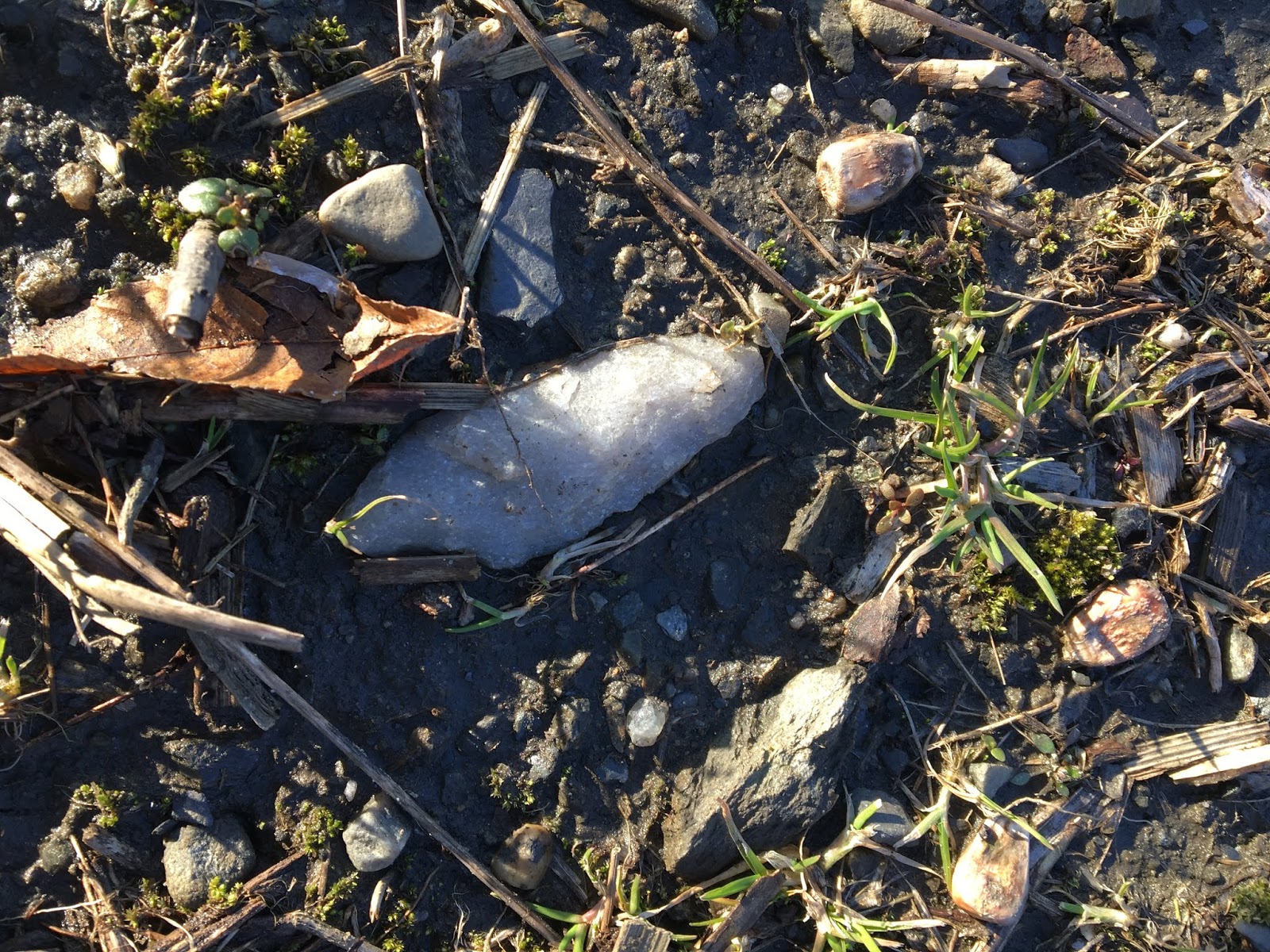
2019 arrowheads
In January I spent a weekend day searching a little rise in the landscape within sight of a large pond. In the past I had found some quartz flakes in a fairly well-defined area on one slope. I searched the slope very carefully and found some broken tools.
 Walking back to the car, in a large flat area mostly devoid of chipping debris, I spotted this.
 I think this is an interesting item. It is made of quartz (as usual), asymmetrical, with a single shoulder. It is large. I imagine this was probably used as a knife. The tip is missing, as usual.

 I spotted this argillite stemmed point on the same day in a different place. It was a good day. I love the defined appearance of the flaking scars on argillite tools. This one has tip damage, too.

 Hours of searching in a different place earlier this month yielded this tiny triangular point. Most of the "arrowheads" I find were probably dart points or knives. It's possible that this little quartz point might be a true arrowhead, that once tipped an arrow fired from a bow. Making a tiny point like this would have taken some skill.
 It stormed pretty hard here in Massachusetts on Monday. But the end of the day was really pleasant, breezy, with a dramatic sky as the sun began to move toward the horizon.
 I searched a favorite place where I used to find a lot of stuff but after hours of searching I hadn't found a single thing. I spotted this at dusk, just as it was getting too dark to see, in an area that is mostly void and that I usually don't spend a lot of time in.
 It is (again) missing the tip but for me this Squibnocket Triangle is still a decent find, representative in many ways of what it is that I am searching for out there. I remind myself that I am very lucky to be able to find anything at all. This is probably from the late Archaic, 3,000-4,500 years old.


Monday, April 15, 2019
Proposed Solar Farm Site (Killingworth CT)

(Karen Lucibello Daigle photo)
...not all that far from Buell Hill:


More:
Sunday, April 14, 2019
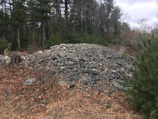
Rock on Rocks - Quissett Woods Mendon
This would throw a nice shadow.

Here, look beyond the gap in the wall. I get the impression this is a line of sight.

Tuesday, April 09, 2019
Very "Fitchburgy" (Fitchburg MA)
- houses behind almost any stone structure.

Westminster Hill Road in Fitchburg MA
4/09/2019
A bit of stone wall at the edge of Development,
Is it atypical of the area
To find something like this,
Along some present day property line?
I mean both the Development
And that stone wall that "ends in"
A flat top triangular boulder,
On some smaller supporting cobbles,
Something about it suggestive
Of a rattlesnakes head,
The curve that resembles an supraocular scale
And perhaps an eye below that:

"I swear," he writes to me,
"That one on top of the flat one has eyes too!"
And at this point I know where he means,
Because he's been showing me example after example
Of stones chosen and placed "just so"
As if these stones were meant to be seen as having eyes,
As if the "Strong Looker," the Uktena were looking at you
At the beginning of a row of stones:

Nearby are other serpentine walls
And sometimes short segments
- could that be a Manitou stone
Almost touching that short row?

Closer:

Step back out,
Observe the water feature
And ponder a bit about
How the stones might relate to it,
How a Snake row of stones
Fits in better with Indigenous land use
Rather than something to do with cows or sheep and all...

A "road-side attraction" I'll throw in, photo'd by Paul:

Tuesday, April 02, 2019
A stroll under the power lines in Bellingham
Actually, I walked in along a power line, seeing a mound at 'A', an interesting split wedged rock at 'B' and a number of brook-side piles of various sorts, around 'C'.

Other things worth showing from my walk include this interesting example of a wedges inserted in a split boulder. I never saw an example like this:
 Some of these inserts look modern. Also, some real effort went into getting those small rock jammed in there. Increasingly I get a sense that there are some modern people, Indians, who know something about the uses of ceremonial features.

 And this pretty little pile by itself near 'C':


I wanted to get to that beautiful landform between the swamp, left of center, and the river, not shown to the left of the map fragment. I guess my legs are getting weak, or the day was getting late, cuz the featureless lowlands discouraged me.
The mound at 'A' was a reasonably typical rectangular mound with inner structure. It is built into a wall. Walking southwest from the road, under the power lines I find:


Looking for details, I do not see much, just that there was some structure, now, degenerate.
[Update: Look again, it is clear someone drove a heavy piece of tread equipment up on top of the pile.]
Looking back:
 I did not find a lot later, so took other pictures at the end of the walk. For instance, of this smaller one a few yards away:
 And some details on the back side, showing the sense of "corner" on the rectangle:
 Showing small "chambers" near another corner:


I see a white rock on top.

Looking for details, I do not see much, just that there was some structure, now, degenerate.

[Update: Look again, it is clear someone drove a heavy piece of tread equipment up on top of the pile.]
Looking back:


Quite a beautiful example. Should be relatively safe, there under the power lines.
Other things worth showing from my walk include this interesting example of a wedges inserted in a split boulder. I never saw an example like this:


For the record, these are called split-wedged rocks or split-filled rocks and not "split-wedged cairns". I discovered them and I get to name them. I assume the users know other names.
Also saw this wall bulge:


Subscribe to:
Posts
(
Atom
)
