Wednesday, September 30, 2015


Tuesday, September 29, 2015
A visit to Upton State Forest


At 'W' was an old well [I know the State Forest people are interested in these locations]:

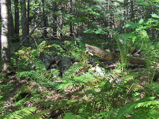
At 'B' was a hole that perhaps I mistook for a bulldozer test pit. Nearby was what looked like a genuinely old rock pile:


And a decrepit, short stretch of stone wall:

Update: I am going to post another site soon that also has a short stretch of wall with a combination of rock pile types. I am starting to "get it" that a typical site always has a calendrical component, while being specific in its particulars. So short stretches of wall are very characteristic, almost by default. Whether it be burial-, astronomical-, or spirit quest- related, in all cases it will be a bit astronomical. The exceptions would be: when it is an individual ceremony- near an energy source or as a donation.
Monday, September 28, 2015

Friday, September 25, 2015
Curious rock with scratches on it (or "Tally Stone")


Curt Hoffman sent this picture of a scratched rock from from the "Little League" site:

Thursday, September 24, 2015
On the Edge of a Wonderland (Westbrook CT)

Another place I've passed by so many times,
I finally stopped just a minute,
To take a picture or two as the sun was setting
On my way home from my Mom and Dad's house,
Headed north up Horse Hill Road in Westbrook CT...

Wednesday, September 23, 2015
From Peter Anick at Neara:
Dr. Curtiss Hoffman will be leading a canoe trip to archaeological sites along the Nemasket River. ... More info here: http://www.savethetaunton.org./programs/canoe.htm
Dr. Curtiss Hoffman will be leading a canoe trip to archaeological sites along the Nemasket River. ... More info here: http://www.savethetaunton.org./programs/canoe.htm
Rock Piles at Egg Rock Concord
I went arrowhead hunting at egg rock because I have heard stories of people finding them there, at the confluence of the rivers, "in the gravel". But I did not expect to find anything and I did not bring my camera along. It is too bad because I saw a stone wall in there on the peninsula between the rivers and immediately hopped across to see if there were any structures beyond it, on the down slope.
 First I saw a low mound, later a rock with an outline.
Then I went on with my arrowhead hunt. A wonderful moment of wading around in the Assabet. The water was warm and I soon got over my sense of "icky" from the uncertain footing. Did not find anything.
On the way back, I took another look at the low mound and discovered it has a smaller secondary one next to it, buried and nearly invisible. Also two or three small "U" outlines nearby. Also a thin trace of wall perpendicular to the main one, leading towards a split rock. I tried to add them in gray on the map above.
Thursday, September 17, 2015
Wall corner piles
Sometimes piles at a corner of a wall can be nice piles (I was not counting them in the previous post). A couple of examples:


Only one rock pile this week
I slogged through a lot of laurel, to no avail. Here, on a small knoll in a wetland, in the middle of nowhere:
 someone used the place.

Tuesday, September 15, 2015


Thursday, September 10, 2015
Knoll-top mounds, at headwaters - Mamjohn Pond, Gardner MA
I mentioned these in an earlier post [click here].
 Was going to park on the road just east of the pond and head for the place where those three brooks meet, north of the pond. But I took a wrong turn and ended up opting for a different entrance to the woods, where Stone Street turns into a dirt road. This was ok as I had also planned to go to the wetland just southeast of the larger blue outline, in the map fragment above. So I parked at the end of "navigation" on Stone Street and continued north along the dirt road.
At the height of land the road crosses just to the west of the summit (see smaller blue outline above) and there is a wall next to the road. But at the high point there was also an extra isolated piece of wall or pile:
 There was a faint depression running along it. I don't know what this is but, it being near the summit, I left the road to take pictures and then continued on through the bushes to the very top of the hill.
I half expected to see another rock pile up there. And there it was:
 or, without the flash:
 You can see it has rectangular elements - a corner in the foreground in this picture:
 From further away:
 I went back to the road and continued north and, it seems to me I found another similar pile but the lighting is so bad, I am not sure, from picture or memory, whether this is a second example.

In any case, I thought it was time to head east, towards the brook confluence, so I headed off from the road, through the ferns. And within 50 yards stepped on another mound (see video here).
 Some other views:
 A fine pile that makes the effort worthwhile.

Apparently there were others as well in the ferns (roughly within the larger blue outline on the map). I had forgotten this one:

And this one with its satellite pile:

 Somewhere else in these woods was a house foundation, without lintel:
 And also more fine examples of rectangular mounds with internal structure:
 Here is one that extended down an entire outcrop, next to a wetland:
 closer:
 After this, I gave up on trying to get to the brook confluence, went back to my car and drove to the originally planned spot. Entered the woods but was a bit tired and obviously I had already had a good walk, so I never did get to the brook confluence. Perhaps I got close to it, with the last pictures.
A fine place. It seems unfair to be in and out, take some pictures, and forget much of it just a few days later. So let us at least take a lesson: that the wetlands at the headwaters of brooks in these towns in north central MA (and adjacent NH) are a good place to look for mounds on knolls or outcrops that poke above the surrounding terrain. You may see rectangular elements of structure, and you may see craters. I think this is the Otter River Watershed.

At the height of land the road crosses just to the west of the summit (see smaller blue outline above) and there is a wall next to the road. But at the high point there was also an extra isolated piece of wall or pile:

I half expected to see another rock pile up there. And there it was:


In any case, I thought it was time to head east, towards the brook confluence, so I headed off from the road, through the ferns. And within 50 yards stepped on another mound (see video here).


Apparently there were others as well in the ferns (roughly within the larger blue outline on the map). I had forgotten this one:

And this one with its satellite pile:


A fine place. It seems unfair to be in and out, take some pictures, and forget much of it just a few days later. So let us at least take a lesson: that the wetlands at the headwaters of brooks in these towns in north central MA (and adjacent NH) are a good place to look for mounds on knolls or outcrops that poke above the surrounding terrain. You may see rectangular elements of structure, and you may see craters. I think this is the Otter River Watershed.
Subscribe to:
Posts
(
Atom
)
