Thursday, January 28, 2016

Nolumbeka Project - February Events

More Nolumbeka Project Announcements:
Saturday, January 30, 10:30 – 11:30 a.m. “10,000 Years at the Falls”presented by the Nolumbeka Project,
Greenfield Savings Bank, 282 Avenue A, Turners Falls, Ma 01376. Joe Graveline and David Brule of the Nolumbeka Project will lead a presentation and discussion of tribal presence at the falls of Peskeompskut (Turners Falls) over the past ten thousand years.  Included will be a recounting of the latest research on King Philip’s War and on the May 19, 1676 massacre that ended the millennia-long era of the peace village at the falls.  Local historians and interested public are welcomed and encouraged to attend.  Light refreshments courtesy of Greenfield Savings Bank.

Saturday, February 6, 2016 - 3:00 PM - Greenfield, MA (from Jonathan Mark, flybynews.com@gmail.com)
Leonard Peltier - 40 years Incarcerated - Clemency Event and Film at Green Fields Market - community room Film - Incident at Oglala is a 1992 documentary by Michael Apted, narrated by Robert Redford. The film documents the deaths of twoFederal Bureau of Investigation agents, Jack R. Coler and Ronald A. Williams, on the Pine Ridge Indian Reservation in the summer of 1975. Peltier was fraudulently arrested in Canada by the FBI using a false witness on February 6, 1976. Is not 40 years enough time for this Native American activist and UN-recognized Human Rights Defender to be locked up in a Federal Penetentiary?Event is to support encouraging President Obama to grant Executive Clemency to free Peltier before leaving office.More information at this meetup URL page:http://www.meetup.com/valley911truth/events/228357324/
Saturday, February 20, noon – 3 p.m.,  Full Snow Moon Gathering, Great Falls Discovery Center, 1 Ave. A,  Turners Falls, MA.   “Indigenous History and Heritage: A Journey” Jennifer Lee (Metis/Narragansett) will share her personal journey as a Native American descendant. Her lifelong passion is learning the true history and culture of this land and about the presence of Native People today. Free. Donations welcome.

TOBACCO TIES 101, SOMETIME BETWEEN FEBRUARY 15 - 19: The ceremonial tobacco harvest at Wissatinnewag this year was excellent and help is needed in creating the tobacco ties used for ceremony and gifts to the tribes. If you are interested in participating please e-mail at this address and we will try to come up with a date, afternoon or evening, the week of February 15 – 19.

Tuesday, January 26, 2016

Monday, January 25, 2016

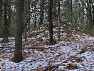
Some rock piles in the snow

A small site next to the start of water, at the upper red outline. Gibbs Mountain is in Raymond Callahan State Park, in Framingham. The lower red outlines are elongated "smears", I'll describe anon.


View southward


Piles at the lower outlines were like this:
It reminded me of the previous weekend (here).

Saturday, January 23, 2016

Thursday, January 21, 2016

Some old mounds?

In the eleventh hour of the "fall", took a quick walk at Raymond Callahan State Park, and headed to the western edge, where there are open fields behind barbed wire. Sure enough some probable mounds but I could not get a good look from the outside of the fence.
From below:
 From the side
And there was a longer one up at the brow of the hill, still farther from the camera:
From below:
 From the side:
I take it that these might be non-agrarian, because the rocks are uniform in size. But the placement is very agrarian, at the edge of a field.
Note these "mounds" are at the western edge of a valley that has other things on its eastern side, as shown by two red dots:
I should mention I once got an angry email from a descendant of Raymond Callahan, correcting my quoting of the topo map - which misnames the park.

Miscoe tributary in the rain

Wednesday, January 20, 2016

The Stony Lady (Morris CT)

A newspaper story from 1991 and a “Chronicle” from an 1859 Litchfield History:
    I had just started seriously looking into the idea of "Indian-made Stonework," mostly by questioning what had been written about zigzag stone walls since my observations of the ones in my yard and near what a local history of my town inferred was a Contact Village site differed so much, when the above story appeared in two local newspapers. Sometime during the previous year, I had read the Litchfield history below (and Manitou by Mavor and Dix as well) and took it upon myself to go back to the library and copy a couple pages for Mr. Towne of an old newspaper article about a seemingly similar "statue" found back in 1834 on the other side of Bantam Lake from his farm:


 Above: the "Stone Image" excerpt; below: the whole of what I copied that includes a bigoted "demonized" view of a young Pootatuck girl's passage into womanhood as a "human sacrifice:"


(Peter, Norman and I once took a look at the "Lady" one day in 1998.)

Sunday, January 17, 2016

First arrowhead finds 2016

I thought this little handful of broken things was worth showing. Nothing great here but better than nothing to show for about 3 hours of searching in the cold today. In the top row, 3 damaged stemmed points. The one in the middle is decent, nicely made, but missing the tip. The one on the left has fairly strong shoulders, most of the points I find from this site, in this shape, have weak shoulders (like the one in the middle) or no shoulders. Below these are a more recent clay pipe stem fragment, the square base of a stemmed point, and the base of what was once a very large triangle. All quartz and all broken as usual...

Nolumbeka Event

Friday, January 15, 2016

Hassanemessit - rock pile sites in the valley of Miscoe Brook, Grafton MA

A former Praying Indian Village.
I have to imagine that there are sites up and down this Miscoe Brook valley. I parked on Salisbury Str. (center left of map) and planned to walk down to the top of the small brook, beside A, and start looking around. There were odds and ends of rock-on-rock and small groups of small rock pile groups, all the way down the slope, from A to B. At B there was a large messy mound, possibly with some hollows, built next to a stone wall. Then I crossed the railroad track, seeing another cluster or two of small piles. At C, I found a nice groups of three mounds connected by trails, that I described here. Then I walked back southeast along the railroad track to the edge of a site at D, that turned out to be extensive. Piles were visible from the railroad tracks at B (both sides) and at D (uphill side). Considering this is about 1/4 mi. stretch, you can see why I expect the whole valley to be full of things. Recall I also found a nice site at one of the Miscoes's headwaters (see here).

For the most part the piles from A to B were not remarkable. Their relation to nearby stone wall occasions some interest:

(Note the quartz behind.) 
More trails through the woods, marked by rock on rock:
And here is the large messy pile, just above the railroad track at B:
 from below:

 ***
At this stage of my walk I had not seen anything exciting. I expected to be writing a post about how pretty the colors of moss were on some of the rocks because of these pictures:


There were other small clusters below the railroad track:
You can see the influence of fire, in the staining of these rocks.


***
Then we come to three mounds at C. The center one is as fine an example as I am likely to see.
I should have said it before while writing about trails, but the connections were roughly like this:
I sketched the trail heading north and disappearing, because I did not go over there. Later, when driving home I saw a huge mound (near 'v' i "Kittyville", marked as E on the first map above, shown here) and conclude in retrospect that it could be connected to the mounds at C. Gosh! there should be lots of other things to see along that trail up and down. But usually when I make that kind of optimistic prediction I am wrong. 
***
Let's take a look at the site at D. This looked like a marker pile site from the railroad track:
I think I see a trail here heading up between two rocks, in the middle of the picture and passing diagonally off to the left, passing rock piles. In fact that leads over to more of the site, so it may be correct. Follow the trail over this bump and you see a beautiful place:
A cannot do better than that. Although there is quite a lot more to see here:


Here is a very messy mound looking back from an adjacent 'ridge', overlooking those piles.
I suspect this is the center of the site and the smaller piles, visible from here, play a satellite role.
Update: The large mound by Kittyville is probably just tailings from gravel removal.

Small mound just east of end of Salisbury Rd, Hassanamessit

Note this in passing. It is obviously a feature of some kind and has similar shape to some larger rectangular mounds with hollows. About 50 yards from the trail head, in the flats to the east.

Stone Wall Segment

Tuesday, January 12, 2016

Trails winding between mounds at Hassanamessit - a new insight

After a light snow, the trails are easier to see so I am just going to show you some trails between three mounds. 

Looking from #2 back towards #1, we see a trail along the right, making an S up to the mound, in the background:
Turning towards #2, I have several shots showing the trails above it, winding around counter clockwise to the right:
Seen from the side, the trail continues around and down to the right:
And then from below:
 
#2 is a superlative mound (no rectangle, no hollow). But please note the trail making a comfortable zig-zag on its way down towards the camera.
 And now we turn around and look towards mound #3:
The trail leads over there, and we can go take a closer look later. 
Here are pictures of #1. With hints of trails around it:

I have been writing about trails leading to rock pile sites and have frequently mentioned seeing old trails passing through a site. I even proposed that some types of vision quests could use a trail to pass by fixed rock piles. Now I believe something stronger may be true: that rock piles were involved in a number of ceremonies, where people move, and that by studying trails at a rock pile site we can observe how people flowed through the place

Take a close look at the picture of #2 from above, I posted the other day:
I make a strange suggestion: is that a circle of trail between us and the mound? What kind of "flow" would explain that? In any case, trails are an essential observable at a rock pile site.
More on this site later.To get to it, park at the end of Salisbury Str. Go straight downhill to the Miscoe. Cross the railroad tracks and look around when you get down just above the flats.