Friday, September 27, 2019

Stone Chamber in Bethel VT

Reader Mark Boettcher writes:

I have a stone chamber on my property that I haven't found referenced anywhere online. It's located in Bethel VT on the Bethel-South Royalton town line on Royalton Hill Rd. 

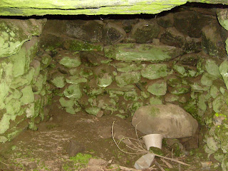
The chamber is built into an old stream bank and faces east. The dimensions are roughly 10' deep, 6' wide and 4'-6" high. The original height is probably more. The bottom is covered in large stones. I lifted one once and found an intact Saratoga Springs water glass bottle dated to ~1880 under it, so I'm assuming those stones were placed later. 

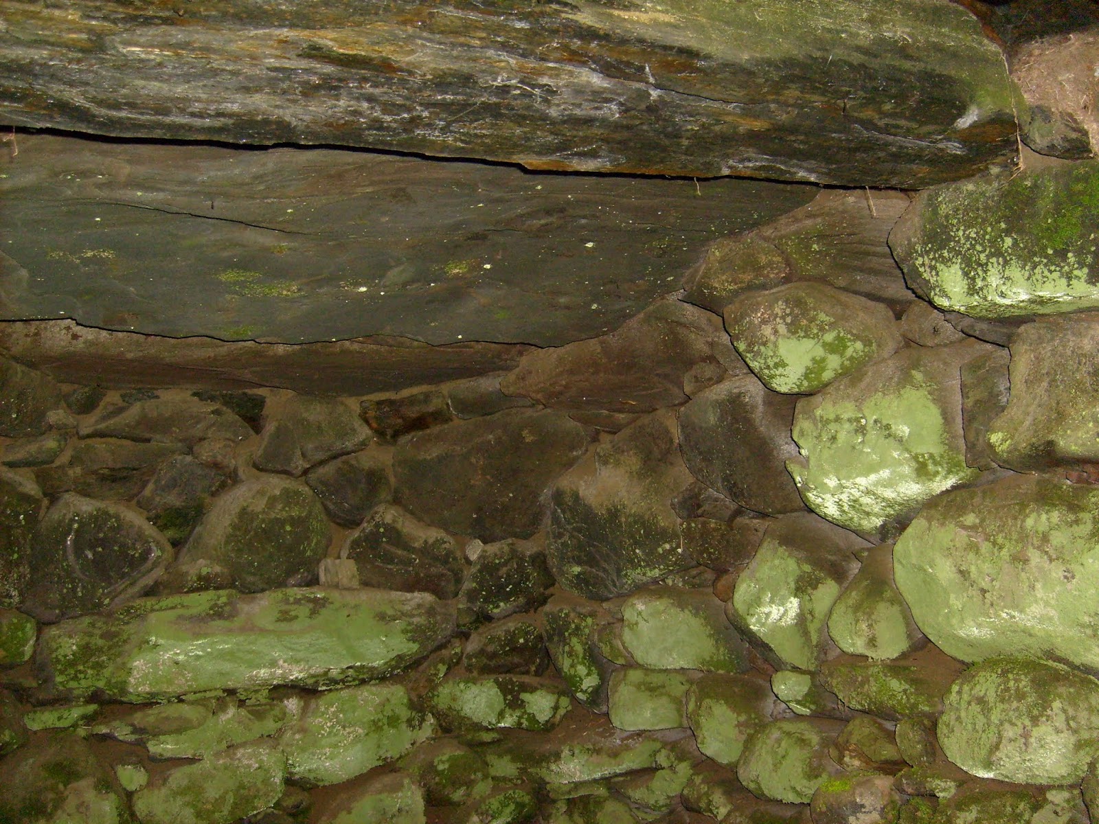
The roof is comprised of three large slabs of stone running parallel, left to right. Each one is somewhere in the neighborhood of 3' x 8' x 8". 

I'm attaching some photos.


There is another stone chamber on the same side of the road in South Royalton, less than 1/4 mile away. That one is in the middle of a field perhaps a couple of hundred yards from the road. It's larger than mine, but I couldn't tell you the exact size.
Update: In a later email:
I stopped by the 2-door-down neighbor's house the other day. It's been at least 4 years since I saw the stone chamber there. The woman who answered the door is renting the house and gave me permission to look for it, but also stated that she wasn't aware of any stone chamber there. The field is pretty big, and I spent about 15 minutes looking without any luck. As I was walking back up, just behind the house was a pile of stones that looked like pieces of the slabs from the roof. I think the person who owns the property dug it up. This is the same person who put a trailer up in the once-beautiful field next door about 2 years ago. Sorry.

Monday, September 23, 2019

Revisiting Quisset Wildlife Management Area in Mendon

The lower blue outline shows where I found a site previously (see here). Other places with rock piles were shown in the report but the major site was at that lower outline. Last Monday I went back with the plan to explore further to the north. So I ended up skirting the wetland clockwise and came across another major site, at the upper blue outline. Because of its relation to the nearby trail this new site is easy to find: from the trailhead at the end of Quisset Hill Rd., take the main trail and go right at the first fork, a few feet in. Follow this trail to the north, with a wetland to your right, and after about 1/2 mile the trail turns left and crosses a brook. Then uphill to a slight dip, as a higher water source drains away to your right (north) back into the main wetland. Follow that lesser, second valley north and you get there. The new site is placed similarly to the old site and skirting the wetland seems to have been a good strategy in this area. I would have found the old site that way and there are other spots with similar topography further north that may contain other similar sites. I'll have to go back. In any case, these sites are located on low ridges that penetrate the wetland.
I want to describe this new site in a bit of detail because it is a very classic mound-with-hollow, to one side of a collection of smaller satellite piles forming a grid - "marker piles". But here the satellite piles had a somewhat unique character: they were square, some having a larger "headstone". Here was the best photo:
The site was arranged like this:
The dots at 'a' and 'b' show mound and satellites. At 'c' there was a split wedged rock with its feet in the water (except it was dry) and at 'd' were a smaller pile and a twin rock-on-rock. 
At 'c':
 At 'd', higher up, above the mound:

Now let's see some more pictures of the "square" marker piles:


Mendon is in the Blackstone River watershed. The comment was made already that things are a bit different from the Nashua watershed. Square marker piles are rare to non-existent further north although I have described similar "boxes" in a variety of places - like Kezar Hill in northern Shirley.

Here are some views of the larger mound:
It is a rectangle with a dramatic piece of quartz at one corner (this corner faces towards the brook that starts below the split-wedged rock).
 Closer:

Covered with growth, it is a bit hard to make out that this is a rectangle with several hollows:
From above:
Panorama:

At first I thought I had stumbled back into the first site I found (lower outline above) but after walking around a while I realized this was a new place with its own special characteristics. All in all a beautiful and undisturbed site with many of the usual elements arranged in a unique way.

Sunday, September 08, 2019

Why not a Levallois Point?

Just making the comparison here, with a basic Levallois Point

(see video here)

The quartz flake I found matches this, flake scar by flake scar:

A bulb of percussion (last flake)

All the other flakes illustrated in the animation.


Levallois Points are from the middle paleolithic, right? This quartz item may have come from deep in the cape cod clay, so it is tempting to create a fantasy narrative about how this item got in my backyard. Whatever the mental contortions, it is a real rock.