Cairns, standing stones, U's, alignments, and stone circles in Colorado. Not sure why "Inc".
Link from Norman [click here]
Saturday, April 30, 2011
Friday, April 29, 2011
Wichahpi Stone Wall - A Unique Memorial to A Native American Woman
"For last 30 years Tom Hendrix has been building, all by himself, a long serpentine stone wall, about 7 km south of Tennessee-Alabama border just off the Natchez Trace Parkway, USA. The wall is a memorial to his great-great-grandmother Te-lah-nay, who at the young age of just 14 years was evicted from her homeland along with her Yuchi Indian tribe and forcibly driven from Lauderdale County, Alabama to Indian Territory (present day Oklahoma) on the infamous or rather the tragic Trail of Tears as a part of forcible resettlement of Native Americans from the eastern United States to Oklahoma...During a conversation with an elder of the Yuchi tribe he was told "All things shall pass. Only the stones will remain." These words gave him the idea to build the stone wall as a Memorial."

The stones assembled near the start of the wall, resemble faces/eyes.
More images from the source at:
Thursday, April 28, 2011
What "variants of the Wachusett Tradition"?
Just thought I would put some structure around my speculations. The phrase in the title calls for some explanation. I see three types of piles with hollows:
Type III:
- large
- rectangular
- single chambered
- built high on hill with view
- usually in pretty good shape
- related to ski jump marker piles
Type II:
- small
- rectangular
- single chambered
- built low, with view over water
- usually pretty beaten down
- related to smeared out marker piles
Type I:
- midsized
- rectangular
- double chambered/rectangular with tail
- built low, with view over water
- almost always completely smeared out
- not related to marker piles.
Something like the following chronology is suggested but it is unclear where the great cairns from NY, PA, and VT fit into the story.

Rock piles next to boulders
I would not want to assume that these are all the same thing, or that it is easy to tell them apart, but one sees these sorts of piles: After I published examples of rock piles with hollows next to boulders, reader robS sent in some pictures from Maine:
 Also:
Also:


 I think these are quite a lot like the piles with hollows built against boulders that I reported from northeastern Groton/Horse Hill [here] and previously from the same site. Also these are not too different from the piles reported at Gates Pond in Berlin [here, last two pics] I have already said I think these are a variant of the Wachusett Tradition. Here are some other's I saw on a southern sub-summit of the same Horse Hill. This is a nice one:
 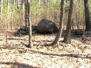 Another view:
 Several others from that southern summit of the hill:

 There were several other rock piles on the sub-summit, and near the top of the main summit, an outline that probably should be noted. The squared blocks make you think this must be a colonial foundation. After seeing all these outlines and hollowed piles, I wonder.
 After I published examples of rock piles with hollows next to boulders, reader robS sent in some pictures from Maine:
 Also:
Also:


 I think these are quite a lot like the piles with hollows built against boulders that I reported from northeastern Groton/Horse Hill [here] and previously from the same site. Also these are not too different from the piles reported at Gates Pond in Berlin [here, last two pics] I have already said I think these are a variant of the Wachusett Tradition. Here are some other's I saw on a southern sub-summit of the same Horse Hill. This is a nice one:
  Another view:
 Several others from that southern summit of the hill:

 There were several other rock piles on the sub-summit, and near the top of the main summit, an outline that probably should be noted. The squared blocks make you think this must be a colonial foundation. After seeing all these outlines and hollowed piles, I wonder.
Western PA Rock Piles
Reader Bill writes:
I found these rock piles several miles north of where I live, a few miles north of a place called Dilltown which is along Rt 403 which comes out of Johnstown.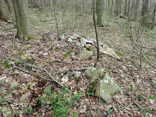


 The rock mounds were about around 8 ft long and 1-2 feet high.
See also: Bills own rock pile [click here]
I found these rock piles several miles north of where I live, a few miles north of a place called Dilltown which is along Rt 403 which comes out of Johnstown.


 The rock mounds were about around 8 ft long and 1-2 feet high.
See also: Bills own rock pile [click here]
Tuesday, April 26, 2011
"Stone Piles"
"The Landlocked Forest - also known as the ‘Landlocked Parcel’ - is Burlington's largest unprotected forest," according to the Friends of the Landlocked Forest - http://www.landlockedforest.com/
Lot's of high quality photos including interesting "stone walls" and "stone piles," such as photo#84. 
Monday, April 25, 2011
Mine Brook, Sudbury MA (part 2)
 Let's continue north, across the little seasonal brook and see what there is to see over on the other side within the "V" of stone wall. First we see a nice rock pile:
 Is that a rusted out model-T or -A? There is little doubt the vehicle owner knew the rock piles were there. This pile is in pretty good shape and, for that, is probably recent. No reason to not equate it with the age of the rusted vehicle.
Just a few feet back from this first pile was another built next to a larger rock:
 Hard to escape the impression that this might be of the same type as the rock piles from northeast Groton - with hollows but built against boulders. In a later post, I'll show some more of these. But the timing is wrong for the rusted Ford. I mention the pile is like a "mound with hollow" as that would be consistent with what we saw first before the stepping across the seasonal brook.
Continuing along the edge of the wet area - which I think must be the so-called "mine brook", there were a few rock piles built on the ground and then a little structure in the brook:
 The line of broken rocks (like a spine in the foreground) is certainly not very colonial or practical looking.
Another example of rock piles juxtaposed with (rusted out) modern items, this looks like a deliberate "ceremony":
 Also in there was a broken down foundation or something:
 I thought this rock pile was noteworthy:
 It has the symmetry of an effigy, with the head towards the camera. Another view:
 This does not look like it has been disturbed.
A peculiar medley. Surprising to find such things, squirreled away behind the suburban houses.
Interesting Legend
It's interesting, all the stones mentioned - stone walls, ruined stone walls, small and large boulders, boulder clusters and cairns, boulder fields and stony ground and bare rock - in the legend of this Delaware Valley Orienteering Association (DVOA) Map: http://www.dvoa.org/gadget/kartat/114.jpg

("Orienteering is a family of sports that requires navigational skills using a map and compass to navigate from point to point in diverse and usually unfamiliar terrain, and normally moving at speed. Participants are given a topographical map, usually a specially prepared orienteering map, which they use to find control points.[1] Originally a training exercise in land navigation for military officers, orienteering has developed many variations. Among these, the oldest and the most popular is foot orienteering. For the purposes of this article, foot orienteering serves as a point of departure for discussion of all other variations, but basically any sport that involves racing against a clock and requires navigation using a map is a type of orienteering."
- http://en.wikipedia.org/wiki/Orienteering )
I just sent the link to someone interested in ancient stone work who lives down Delaware way...
Friday, April 22, 2011
Mine Brook, Sudbury MA (part 1)
 The reason for going to explore flat wetlands in a part of Sudbury that might be rocky are that I have been chasing a "hyrophilic" branch of the Wachusett Tradition with linear features and rectangular mounds with hollows situated near water, with views over water, and with complex site layout. I have been chasing it from Pelham NH, through northeast Groton, Clinton, Berlin, Boylston, in places like Framingham, and - I hoped - in Sudbury.
I did find a site with linear features and the same sort of complex site layout but the only pile with a hollow was a bit questionable. Also there seemed to be more modern, less damaged, piles built up on boulders and a rusted out Model-T. Still later, a bit of brick. So it could all be modern. I prefer to imagine the rock piles and wall elements were there earlier. A sketch:
Here is the linear feature, next to the wetland at the bottom of the above sketch: Lengthwise:
 And if you look past the end of this feature, you can see one end of the right hand "V" of wall with a faint brook running down between.
 Also, behind the bottom wall were three or more ground piles :
 They were not in a straight line but in some places looked to be almost in a curve.
Then you go across the brook. Here is a panorama taken looking back from the other side:
 Favorite pic from over there:
 Too much more to blog about in one pass.
Thursday, April 21, 2011
Lincoln Landfill - small rock piles by a spring
 Poking around the edges of woods near home, I found a small site next to the artificial hill of the Lincoln Landfill. I parked where Paul Revere was captured, crossed 2A and walked into the woods to the south but keeping to the left. Just after crossing the hill, I noticed a rock pile in a puddle: Then I spotted about three other piles:
 Another view of the scene:
 Closeups:
 View back towards the landfill:
  These piles did not have a lot of character and the best I can guess is that they were put where water comes out of the ground. But maybe that water is a recent bi product of the landfill.
Wednesday, April 20, 2011
Small rock pile site near southern entrance to Estabrook Woods - Concord, MA
Something was telling me I never looked carefully at the woods at the very beginning of the Estabrook Road, so I went out to comb that part very carefully. Finding a solitary rock pile was no surprise, then I came across some funny things that - in the end - I had to recognize as a sort of rock pile site.
Here is a quick description. Entering the woods following Estabrook Rd from the south, leads past some beautifully manicured mansions. I could not resist this one scene with the first hint of spring color and the thought "and now it begins...." I continued up the road, heading north, and took the left hand path when I got to the initial cross roads. This left hand path is the one called "Estabrook Rd" although it is a dirt path today. Actually rather than taking the path, I headed into the woods to the right of that path and swept back and forth. I found myself on a secondary path, parallel with the main Estabrook Rd. At one point, next to this secondary path, I came across a disturbed rock pile. My pictures are lousy but to get some idea, it kind of snaked around:
 At one end was a larger boulder, like a "head" on a snake:
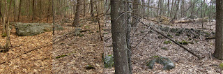 I did not give it much credit. There were some other pile-like collections of rocks nearby, incorporated into a stone wall. I did not give these much credit either. It all just seemed like messy wall construction. But then I spotted this a few feet away:
 I thought "wait a minute...that's a real rock pile". And with that the other piles came into focus as old remnants built into the walls and otherwise part of a small site. Here is a view southward of the small valley I was in.
  The notable pile is one of two on the left. On the right, a wall comes up (from the south) and tops the knoll with another rock pile. The "snake" is behind me while taking the photo. I should have blogged about this at the time, two weeks ago. Now I cannot remember how many piles in all or how exactly they were placed. Something like this: two piles downhill from the snake, the "notable" and adjacent piles, the one on the knoll, and two boulders with loose rocks on top.
  An interesting structured layout. It is not just an array of evenly (or unevenly) spaced piles of the same sort. Frankly it reminds me of some of the Wachusett Tradition sites I have looked at recently.
Here are some of the piles. Downhill from the "snake":
 Here is a the "notable" pile:
  Looks a bit familiar, eh? [Try drawing the outline]. Here is a detail:
  Here is a small neighboring pile:
 I did not get any decent photos of the boulders with scattered rocks on top. Here is a view back over to the knoll:
 A picture of the pile on top of the knoll, trying to make it look like a pile rather than a brief widening of the wall:
  Definately an easy walk: 3 minutes from the entrance, following Estabrook Road, on the right at the point where the first dip occurs to the left.
Here is a quick description. Entering the woods following Estabrook Rd from the south, leads past some beautifully manicured mansions. I could not resist this one scene with the first hint of spring color and the thought "and now it begins...."
 I continued up the road, heading north, and took the left hand path when I got to the initial cross roads. This left hand path is the one called "Estabrook Rd" although it is a dirt path today. Actually rather than taking the path, I headed into the woods to the right of that path and swept back and forth. I found myself on a secondary path, parallel with the main Estabrook Rd. At one point, next to this secondary path, I came across a disturbed rock pile. My pictures are lousy but to get some idea, it kind of snaked around:
 At one end was a larger boulder, like a "head" on a snake:
 I did not give it much credit. There were some other pile-like collections of rocks nearby, incorporated into a stone wall. I did not give these much credit either. It all just seemed like messy wall construction. But then I spotted this a few feet away:
 I thought "wait a minute...that's a real rock pile". And with that the other piles came into focus as old remnants built into the walls and otherwise part of a small site. Here is a view southward of the small valley I was in.
  The notable pile is one of two on the left. On the right, a wall comes up (from the south) and tops the knoll with another rock pile. The "snake" is behind me while taking the photo. I should have blogged about this at the time, two weeks ago. Now I cannot remember how many piles in all or how exactly they were placed. Something like this: two piles downhill from the snake, the "notable" and adjacent piles, the one on the knoll, and two boulders with loose rocks on top.
  An interesting structured layout. It is not just an array of evenly (or unevenly) spaced piles of the same sort. Frankly it reminds me of some of the Wachusett Tradition sites I have looked at recently.
Here are some of the piles. Downhill from the "snake":

 Here is a the "notable" pile:
  Looks a bit familiar, eh? [Try drawing the outline]. Here is a detail:
  Here is a small neighboring pile:
 I did not get any decent photos of the boulders with scattered rocks on top. Here is a view back over to the knoll:
 A picture of the pile on top of the knoll, trying to make it look like a pile rather than a brief widening of the wall:
  Definately an easy walk: 3 minutes from the entrance, following Estabrook Road, on the right at the point where the first dip occurs to the left.
Subscribe to:
Posts
(
Atom
)
