
Sunday, October 31, 2010
Saturday, October 30, 2010
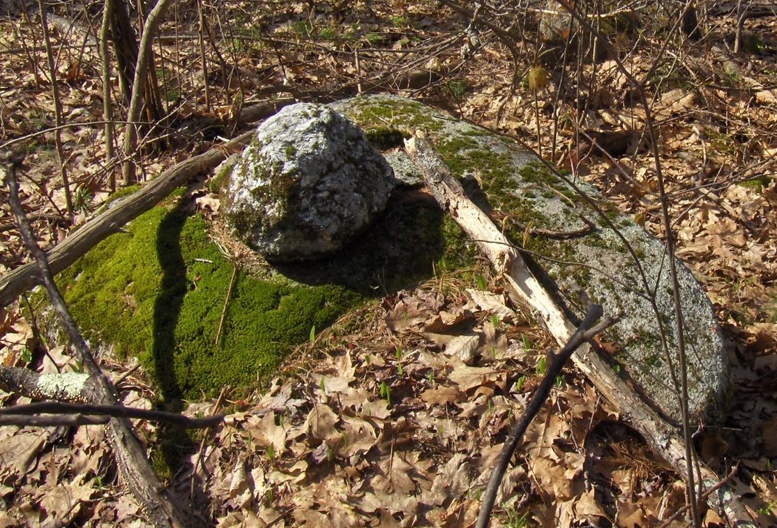
Berne NY Rock Pile
Reader Cully writes:
I have passed this rock pile a few times and never gave it much thought until today. Its located in Berne, NY 12023 at approx. 42° 35.857' N 74° 06.526' W. Its built on a solid slab about 10' x 10'. I have seen no other base rock like that in the hiking area. Could be a glacial erratic.The area was once farm or pasture land as there are many rock walls through the forest. Its on the top most part of a hill plateau 100' from the edge and if there were no trees would overlook a valley. There is an old cemetery about 1/4 mile away and the last burial that I can distinguish is 1902, the ealiest is 1860. I am not an accomplished geologist but it would appear that 2 of the gravestones are of the same slate as the stone in the rockpile.


I have passed this rock pile a few times and never gave it much thought until today. Its located in Berne, NY 12023 at approx. 42° 35.857' N 74° 06.526' W. Its built on a solid slab about 10' x 10'. I have seen no other base rock like that in the hiking area. Could be a glacial erratic.The area was once farm or pasture land as there are many rock walls through the forest. Its on the top most part of a hill plateau 100' from the edge and if there were no trees would overlook a valley. There is an old cemetery about 1/4 mile away and the last burial that I can distinguish is 1902, the ealiest is 1860. I am not an accomplished geologist but it would appear that 2 of the gravestones are of the same slate as the stone in the rockpile.


Thursday, October 28, 2010

Wednesday, October 27, 2010
Tuesday, October 26, 2010
xenolith/xenocryst

Monday, October 25, 2010
Bears Rocks, Pennsylvania

I thought I wouldn't be posting again for a while, but our son is home from a very flat area of Ohio and wanted to get to the mountains, so I found myself at Bears Rocks on the Kittatinny Ridge yesterday. To my surprise, the propped rock I referred to in a previous post had been rebuilt, see above. One can never know, but it probably wasn't done by traditional people, as some other curious constructions had also been created.
 Above is one of the new stone constructions I spoke of, a swirl of piled stone with a seat visible at the center back. I suspect this was put together by partying visitors, and they may have reconstructed the propped rock, too. There's no way of knowing, but it's interesting to see that these things are happening.
Below, a gratuitous autumn shot. Those in the picture probably aren't very old, but some moss and lichen communities are aged, possibly in some cases thousands of years old. The forests present when Europeans arrived are all but gone, but these ancient communities of mosses and lichens, especially those tucked between stones on rocky ridge tops, have remained for the most part undisturbed and are representatives from that time we all wish we could visit or conjure in our minds.
 Okay, now re-posting the photos that caused a little controversy. The first one below is of an indentation in the rock at the very highest place at this lookout, a natural stack of rock about 20-25 feet high, overlooking the propped rock. I've been coming here for about 40 years and always noticed this hollow, partly because of its placement and partly because of the relative smoothness of its sides and floor. It's probably 10 inches to a foot in diameter at its widest point. Earlier I suggested it might have been used as a mortar for healing herbs by indigenous people who wanted to permeate them with some of the power of this impressive place, that looks out over a broad valley to the north and a partially obscured but equally broad expanse to the south.
Doug Watts posted a comment below saying it is a xenolith, meaning that at one time there was another kind of stone embedded in this one and when it came loose it left this hollow. He seems to think that this eliminates all possibility of human use.

Paint and the darkening, which could be soot, are no doubt from the partying young people mentioned before.
The second picture is of another hollow in stone some distance away from the main part of the lookout. I took this on the same day for comparison with the one above. It and a few others I found were all much rougher looking than the first, and have much less of a worn look. The sides in particular are rougher and slope more gradually.
 I re-post these because a couple of people asked me to. I am not saying that I know whether the rock bowl was ever used as a mortar. I sent these photos to Norman Muller at his request and he pretty much agrees with Mr. Watts. I have a great deal of respect for Norman's accumulated knowledge on these subjects, so I'm inclined to think he's right. However I leave a little door of possibility open, partly because at a lookout I was shown in Warren County, New Jersey I saw a similarly worn indentation in rocks, in the shape of an animal paw.
 I re-post these because a couple of people asked me to. I am not saying that I know whether the rock bowl was ever used as a mortar. I sent these photos to Norman Muller at his request and he pretty much agrees with Mr. Watts. I have a great deal of respect for Norman's accumulated knowledge on these subjects, so I'm inclined to think he's right. However I leave a little door of possibility open, partly because at a lookout I was shown in Warren County, New Jersey I saw a similarly worn indentation in rocks, in the shape of an animal paw.
Sunday, October 24, 2010
The Little Roadside/Indian Trail Turtle Link

Click Here for: the Little Roadside/Indian Trail Turtle Story
Saturday, October 23, 2010
Took a lot of pictures today.
Went on the NEARA field trip to the Manoosnoc's. Lotta pictures! and I haven't finished posting from last weekend.
Friday, October 22, 2010
Ancient Native Site with Numerous Mounds and Stone Structures
Madis Senner writes:
Friends, I have just posted my review of South Hill at the southern end of Canandaigua Lake at: http://www.jubileeinitiative.org/sacredsouthhill.html South Hill contains numerous stone mounds and other stone structures that were most likely created by the mound builders, Hopewell and Adena. I ask that you please contact the NY DEC, information contained within the review, and ask that they please help preserve the many stone structures on South Hill. It would be a pity to see these stone structures pilfered or damaged the way that stone structures on Bare Hill were decades ago. Bare Hill also on Canandaigua Lake is where the Seneca people held their council fires. The Seneca people believe that they were born at South Hill. Please visit South Hill and keep it in your prayers. Peace,Madis Sennerwww.motherearthprayers.org
Friends, I have just posted my review of South Hill at the southern end of Canandaigua Lake at: http://www.jubileeinitiative.org/sacredsouthhill.html South Hill contains numerous stone mounds and other stone structures that were most likely created by the mound builders, Hopewell and Adena. I ask that you please contact the NY DEC, information contained within the review, and ask that they please help preserve the many stone structures on South Hill. It would be a pity to see these stone structures pilfered or damaged the way that stone structures on Bare Hill were decades ago. Bare Hill also on Canandaigua Lake is where the Seneca people held their council fires. The Seneca people believe that they were born at South Hill. Please visit South Hill and keep it in your prayers. Peace,Madis Sennerwww.motherearthprayers.org
Another Familiar Shape
Above is PWAK's photo, below is mine...

http://wakinguponturtleisland.blogspot.com/2010/10/another-familiar-shape.html
Thursday, October 21, 2010

Wednesday, October 20, 2010
Saturday field trip to Leominster and the "Capital of the Inland Empire"
[Borrowed from Peter Anick's NEARA announcement]
Enjoy fall colors and cairns. Weather still looking good for Saturday.
[PWAX] will guide us through one of his favorite areas and offer his interpretation of the site. The first section will be relatively easy walking. Depending on interest and time, we will likely visit some other sites nearby in the afternoon. Bring all the usual stuff: lunch, water, sturdy shoes, bug repellant, cameras, orange vests (or bright colors).
> Meeting date time: Saturday Oct 23, 2010 at 9:30AM
> Directions to 1080 Mt. Elam Road, Leominster MA
> Note that there is no exact street address for our destination, but on Google maps, using the address 1080 Mt. Elam Road gets you pretty close. 1080 Mt Elam Rd is south of Rt 2 between the Rt 12 and Rt 31 exits. Because Mt Elam Rd is split by Rt 2, you can only get there when coming from the west on Rt 2.
> From the east: take Rt 2 to the Rt 31 exit, exit and then get back on Rt 2 and follow the directions below for coming from the west.
> Coming from the west on Rt 2: after passing the Rt 31 exit, take the second right hand turn onto Mt Elam Rd. Go all the way to the end (of the paved portion) and park.
Looking around the Hockomock Swamp in Easton, Mass...

Only the Curious have something to find...
More treasure hunters digging up "Indian Graves"
Tim McSweeney found this [click here] on "Treasurenet". It includes photos of evenly spaced rock piles from the Tennessee/Virginia area, along with various theories . The phrase they keep using is "if I see bones, I will stop digging". I wonder if the FBI should look into these people who are openly discussing committing felonies?
Visit "Waking up on Turtle Island" for several interesting posts, including more discussion of how meth addictions are compounding the problem of excavating graves in Ozarks.
Visit "Waking up on Turtle Island" for several interesting posts, including more discussion of how meth addictions are compounding the problem of excavating graves in Ozarks.
Tuesday, October 19, 2010
EMC open space plan to be discussed in Southborough
Reader Susan alerts us to a meeting. If anyone can go please do:
I just came across your latest post about the rock piles at EMC (http://rockpiles.blogspot.com/2010/10/emc-slow-motion-train-wreck-in.html). I hadn't realized they were starting to build over there.
I thought you might want to know that at their meeting tonight the Southborough Selectmen will discuss the EMC open space plan. I haven't seen the plan, so I'm not sure what if anything it has to do with the area near the rock piles. The meeting is open to the public and you are free to go and comment. Here's a link to the agenda: http://southboroughtown.com/Agendas/BOSAg101910.pdf.
Monday, October 18, 2010
Northeast of Great Brook Farm - Carlisle MA
Great Brook Farm in Carlisle is full of manipulated rocks and walls, especially to the north. Hard to picture but...for example this: A short stretch of "wall" that snaked back and forth and crossed a knoll, in its brief existence.
Some more familiar objects, split-wedged rocks: closer:
 Note the steel drill marks on the above, are absent on this one below:
 closer:
 A short stretch of "wall" that snaked back and forth and crossed a knoll, in its brief existence.
Some more familiar objects, split-wedged rocks:
 closer:
 Note the steel drill marks on the above, are absent on this one below:
 closer:
Sunday, October 17, 2010
Hike to Sunset Rock, Greene County, NY

During the same vacation we went to New York's North South Lake Campground and Day Use Facility in Greene County (I see on the blog that Norman was at this same park in September and visited Alligator Rock, which we failed to see.) and hiked along the Catskill escarpment to Artists Rock and Sunset Rock. We stayed on the much-traveled trail and didn't see any rock piles except those modern arty ones you see a lot on mountains these days. I wouldn't be surprised if there were rock piles in some numbers off trail.
We did, however, see propped rocks. I know this gets discussed here from time to time. I came upon it a few years ago writing an article for the Megalithic Portal about Vottovaara Mountain near the Russia/Finnish border where there are many seid or seitas most of them known to have been placed by people. Since then I have observed them at a number of lookouts I've visited.
 The one at the top of this post is placed near the lookout known as Artists Rock. From there you can see a stunning view including mountains in four states. The propped rock just above and the one below were both at notable places. (I remember thinking so but cannot remember just which notable places they were at because I failed to take notes at the time.)
 I have also seen propped rocks at Huckleberry Point, another Catskill lookout, at Ringing Rocks, especially above the waterfall but in other spots, too, and at Bears Rocks (this one has since been destroyed), a lookout closer to home along the Kittatinny Ridge. I noticed the one at Bears Rocks long before I got involved with all this and even tried writing to Salvatore Trento about it, back in the 1980s 0r 90s when his and Barry Fell's books were the only reading material I had on this sort of thing. The propped rocks are often just to the side of the lookout, away from where people gather. It's worth looking around for them if you hike.

 Also on the way between Artists Rock, named because the Hudson River School painters admired the view and set up easel there sometimes, and Sunset Rock, I spotted this large split wedged boulder.
 And then at the top, once again just off to the side from Sunset Rock itself, I saw the propped rock below. The small picture at the bottom is the view from up there, showing where the Catskills end and slope into the Hudson Valley.
Peter has said that for natural processes to have produced the large concentration of propped boulders at Foxborough in an area where they are otherwise absent or unusual is a statistical impossibility. Similarly the tendency for these things to crop up wherever there is a stunning view or other spirit-lifting prospect is at least an improbability. In Finland and northwestern Russia there would be no doubt that these stones were placed or at least propped by man.


View of the Mountains from Sahler Mill Road(s)
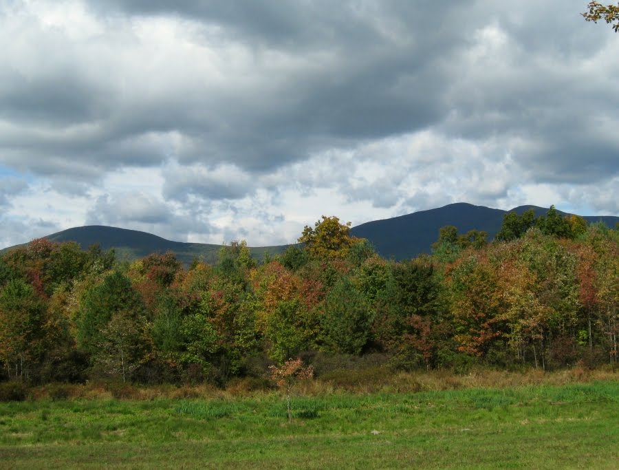 Posting this to demonstrate what a striking and rather feminine view the peaks present.
Saturday, October 16, 2010
Ted Hendrickson writes...
Thought I would send this along in regards to Geophile's post and comments about sites with views of prominent mountains. I have been shooting stone circles and other landscape features in Ireland for a while now and have noted the same. Ritualized sites all seen to be focussed on a sweeping view or significant landscape feature. I enclose a sample from this past summer's trip to Co. Kerry. The circle at Gurteen had a view of the mountain pair The Paps, the breasts of the goddess Anu.
 The effect is enhanced by cairns at the top of each, suggesting nipples. The second shot is a view of the Paps from the circle. I assume the earth goddess would approve of the wind farm to the right.
 The circle at Gurteen had a view of the mountain pair The Paps, the breasts of the goddess Anu.
 The effect is enhanced by cairns at the top of each, suggesting nipples. The second shot is a view of the Paps from the circle. I assume the earth goddess would approve of the wind farm to the right.
Mountains in Alabama
I had fogotten this from the Anniston Star:
...The mountain, which Holstein would not name for fear of advertising the site to looters, contains 80 acres of mound structures....[click here]
(That's a lot of stone mounds)
...The mountain, which Holstein would not name for fear of advertising the site to looters, contains 80 acres of mound structures....[click here]
(That's a lot of stone mounds)
Turtle Rock Rosendale NY (Ulster County)

The caption reads: "I could not resist a picture of the "turtle rock" on Main Street"
- PHOTO TAKEN 2/22/02
http://www.townofrosendale.com/ourtowninpictures.cfm
Friday, October 15, 2010
Poison Sumac
I kind of doubted the existence of this stuff, since poison "oak" is just a California version of poison ivy. But indeed, this is a different plant in the family. You can see the shape of the poison ivy leaf in the form of the last three leaflets: It is pretty:
 This is from a bog in Andover at the Ward Reservation.
 It is pretty:
 This is from a bog in Andover at the Ward Reservation.

Another thing about rock pile half-life
Recalling the discussion here . Another point can be made if a site incorporates two different styles of rock pile. If the damage is equal regardless of the style, then that would be one thing. But if one style was more damaged, on average, than the other at the same site, it would be reasonable to place that style as earlier in the chronology.
In this way, I think it is fair to say that the rectangular marker piles are older than the triangular ones.
In this way, I think it is fair to say that the rectangular marker piles are older than the triangular ones.
Lower Sahler Mill Road, Ulster County, NY
 I had walked Upper Sahler Mill Road on another visit but this was the first time we continued onto Lower Sahler Mill Road to go out to County Route 2 and back to the car. We passed lots of rock piles (and many more walls) along the way but I figured they were from road construction. Then we came upon this double wall construction, something I'd seen before in more than one stone complex in PA. It led downhill to what looked like a low marshy area.
 Maybe 100 to 150 feet on, just past the farmhouse, was a wall and then this grazing area. The large stone is probably not a rock pile, but behind and around it were small piles on small boulders. I include this picture as much to show how Slide Mountain dominates the area as for the stones.
 Leaving that farm the road entered woods and the first thing I saw was this pair of wall-linked boulders. This was very different from the many walls we'd seen going straight along fields so far.
 On the other side of the road I saw these rock piles.
 And the the wall above, leading uphill to a huge boulder.
 Further along, more piles, somewhat better formed. Note the big one in the upper right hand part of the picture.
 And this split wedged boulder with what appears to be a rock pile behind it. I've looked at some of my other pictures since (I was on a moss and lichen photo kick just then) and found other piles too distant and fuzzy to post.
 My last pic is this wall with a huge pine tree growing out of it, showing it has been there a while. I have another (shorter) set of pictures from our hike to Sunset Rock in Greene County and I'll post them soon. Thanks to Peter and everyone for letting me post.
Does this group still exist?
INDIAN BURIAL AND SACRED GROUNDS WATCH
http://www.ibsgwatch.imagedjinn.com/index.htm
Mission Statement
The Indian Burial and Sacred Grounds Watch web site exists as a tool for purveying and disseminating news on relevant issues which may appear on the internet and email lists. Its purpose is not to duplicate the efforts of others but hopefully to assist in the directing of individuals to items of interest. As many preservation efforts call for petition, letter and phone campaigns, the Indian burial and Sacred Grounds Watch web site has compiled a number of links to state and federal representatives, and other pertinent, potential contacts as an aid to individuals who would wish to pursue activism. For those who wish to be better informed, there is also a compilation of links and online material which may help educate in awareness as to the laws which effect relevant issues. Believing that there may be many who wish to involve themselves in activism, yet may be unsure about their ability to help, it's hoped that this web site may ultimately provide some basic assistance. If the Indian Burial and Sacred Grounds Watch web site proves helpful to even a single individual or preservation effort, then its purpose is served.
Online Petitions
http://www.petitiononline.com/ provides free online hosting of public petitions for responsible public advocacy. A good suggestion is reading and studying other petitions. PetitionOnline suggests that for experienced advice on writing persuasive letters and petitions one should take a look at the book Shocked, Appalled, and Dismayed! How to Write Letters of Complaint That Get Results by Ellen Phillips.
ibsgwatch.webmaster@mindspring.com
IBSGWatch (Indian Burial and Sacred Grounds Watch)
General contact and webmaster, Juli Kearns. Please contact me if you have news, updates, suggestions for links etc. for the web site.
onondaga@tsalagi-l.net
Edward Reynolds heads the Indian Burial Grounds Action Group.
I'll add this: "Burial cairns are generally large (10+ ft) and tend to be located on the highest points in the area. Conical mounds commonly contain more than one burial...Human remains do not need to be present for a location to be a final resting place.
Cairns are sometimes made to ensure that... (i)f that individual should die while away from his homeland, the cairn will ensure that the spirit will return to its home.
Those markers without human remains are no less sacred than those that are associated with human remains..."
APPENDIX D ARCHEOLOGICAL FEATURES (FROM PETERSON 2003)
If you are from IBSGWatch (or know anything about a current similar group), this is a plea in reference to a threatened ceremonial and possible burial site in Massachusetts.
Please see:
http://wakinguponturtleisland.blogspot.com/2009/10/emc-threatens-indian-sacred-stone.html
http://rockpiles.blogspot.com/2010/10/emc-slow-motion-train-wreck-in.html
Thursday, October 14, 2010
who is saveNipsachuk.org?
Does anybody know? I was just reading my own posts and see that the rockpiles blog is the sole information conveyed at this *.org's webpage and it would be nice to know who this is that is along for the ride.
Wonderful West Virginia
Norman Muller sent this from a friend of his Don (The Gage's are quoted and I think this might have been linked to before):
In case you were not aware of this recent publication, I pass this along should it be of interest. Click here: Wonderful West Virginia
[PWAX: A couple choice quotes are:
"Common to cultures across the globe, cairns are manmade structures that range from loose stone piles to carefully built towers. They were erected by ancient peoples to indicate sites of special events, such as battles. They were also used for navigation and astronomical observations, as well as for burial markers. Today cairns are commonly used by hikers as trail markers and can be found along well-traveled routes like the Appalachian Trail." - looks just a wee bit plagiarized but thanks anyway.
"There is no doubt in my mind that this is going to turn out to be the most significant site in the state of West Virginia," he says. "There isn't anything that approaches it."
Does anyone else think this is like the California walls?
In case you were not aware of this recent publication, I pass this along should it be of interest.
Fitzwater, Leslie
2010 Silent Stones. Wonderful West Virginia 74(3):10-15.
Text accessible at:
[PWAX: A couple choice quotes are:
"Common to cultures across the globe, cairns are manmade structures that range from loose stone piles to carefully built towers. They were erected by ancient peoples to indicate sites of special events, such as battles. They were also used for navigation and astronomical observations, as well as for burial markers. Today cairns are commonly used by hikers as trail markers and can be found along well-traveled routes like the Appalachian Trail." - looks just a wee bit plagiarized but thanks anyway.
"There is no doubt in my mind that this is going to turn out to be the most significant site in the state of West Virginia," he says. "There isn't anything that approaches it."
Does anyone else think this is like the California walls?
Upper Sahler Mill Road, Olive Township, NewYork
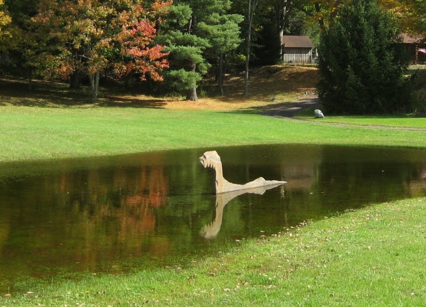 I've been absent from the blog for a while, but a trip to Ulster County, NY has brought me back. We used to live there and still go up for vacation. This time we took a walk around Upper and Lower Sahler Mill Road in the township of Olive. When we passed the loch monster above a half mile from the turn-in, I should have guessed we were in for a few more stony surprises.
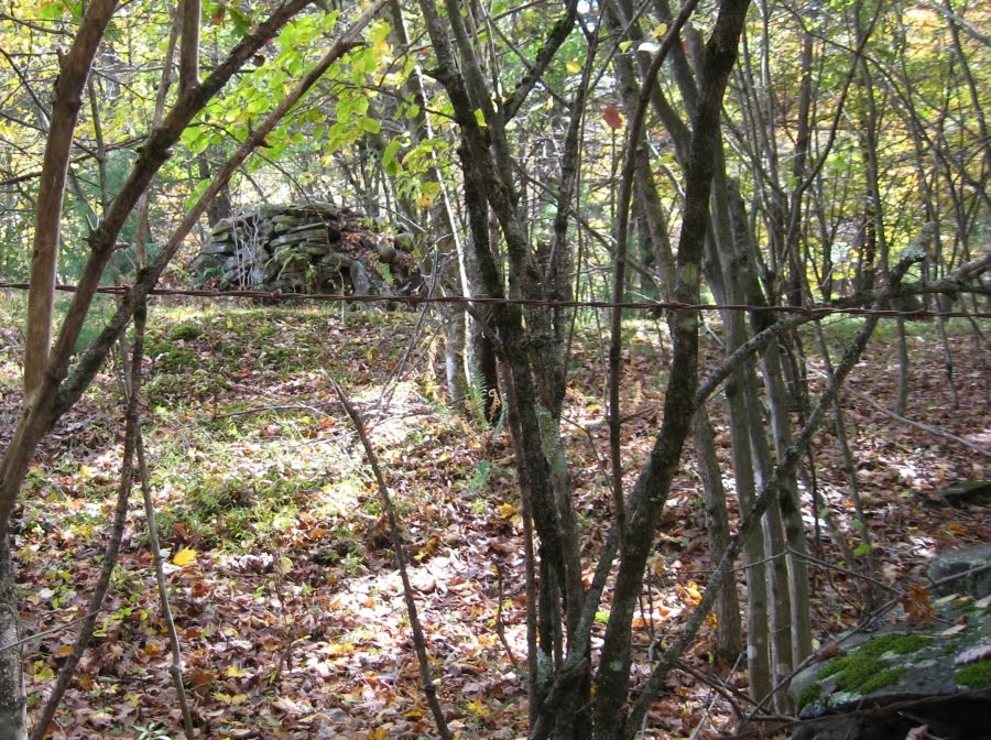 There are loads of walls along the Sahler Mill Roads, most of them probably field clearing. It's stony up there. But after seeing many handsome walls and roadside rock piles that I figured were from road building, I spotted the rock pile above, well back from the road, and after that began to keep my eyes open.
 I saw this handsome fellow not far away. The spotting of effigies is always subjective, but a good case could be made for this being a wood buffalo. Or maybe it's just me.
 Of the many walls along Upper Sahler Mill, the one above seemed to be the oldest, with many of its stones covered with lichen and moss. But I wouldn't be posting these if that was all we saw. In a day or two I'll try to get back and post what we saw after we turned the corner at the Sahler mill pond and headed back along Lower Sahler Mill Road. There were more rock piles, a split wedged boulder, a short wall running between two boulders, and hints of more back in the woods where I couldn't go. It may be worth mentioning that from many places along these roads you can spot peaks of the Catskill Mountains. Could that be one factor in its being a ceremonial area?
Below, a gratuitous shot of the beautiful mill pond that marks the transition from Upper to Lower Sahler Mill Road. There was witch hazel in bloom nearby, too, Peter.


Subscribe to:
Posts
(
Atom
)
