Wednesday, December 25, 2024
Friday, December 20, 2024
Unusual carved rocks
This is so weird. I thought it my interest you, although not rock pile related:
Thursday, December 19, 2024
Lower Wildcat Wash - Moapa Nevada
I thought I already described this place but I cannot find any posts about it. Luckily I still have the photos. So here goes:
If you walk south from NV 168 along Wildcat Wash, leading in towards Arrow Canyon, you are following a well travelled path (note the prominent Yucca, left of center):

To either side, is a dense pavement of broken rock, bunt rock, and lithic debris. Here, someone broke apart a nice cream-colored block of chert, with pieces scattered around for several yards. Otherwise, they are still sitting where someone left them - too big to be moved around much by erosion.

And then, what-do-ya-know, you come across a rock pile. You think: this does not look very old. But then think: Yeah but those lithic fragments did not look too old either. So, who knows?

You notice a propped slab. This is more likely to be recent. This pair of Yuccas appear as a single plant in the earlier photo. The propped slab does not look like it could be very ancient.

To the left, at the edge of the gully is another rock pile.

(You can still see the phone lines along NV 168 in the background.)


I wonder what someone might be up to out here. Perhaps I can ask the Moapa Indians.
Wednesday, December 11, 2024
Photos from Lake Luzerne NY
[Reader Kevin O. writes:] Here are a couple more pics.
One is my attempt at a primitive map of where stone piles have been located.

One pic is a profile of the location of three stone piles. example of layout

One pic is a photo of Potash Mt...not a view from where we are. We could have that view but chose 25 years ago not to cut any trees. Mohawk name of Potash Mt is Senongewok. The stones face west toward Potash Mountain

One photo is of Red Hawk. Red Hawk was from Swanton Vt and I believe his mother was Abenki, and father, of European descent. Not 100% sure. Definitely of Abeneki lineage
Red Hawk was an interpreter for Fort Ticonderoga, and the photo is from the State of NY

Tuesday, December 10, 2024
Concave Base Arrowhead from Marshfield
I found this in a place where I look and look and never find more than a smidgen of a broken quartz base. It is one of those late paleo "Snappit" or "Hardaway-Dalton" types that I tend to find inland. This is as close as I have come to finding an arrowhead in this place.

Tuesday, December 03, 2024

Native Americans and the Revolution, Thursday, 12/5
[From the Friends of PineHawk]
Thank you for signing up for "Native Americans in Southern New England and the Revolution" with Daniel Mandell, this Thursday, Dec. 5, from 7-8:30 p.m. in Room 204 of Acton Town Hall, 472 Main St. The program is jointly sponsored by The Friends of Pine Hawk and the Acton 250 Committee.
Note: The program will not be live-streamed. It will be recorded and available later on Acton TV, https://actontv.org/.
Saturday, November 23, 2024
Littleton Conservation Trust Facebook acknowledges Nashoba Indians
Dear Friends of the Nashobah Praying Indians,
The Littleton Conservation Trust has posted in support of the Nashobah Praying Indians for Indigenous History Month!
https://www.facebook.com/
:)
Best wishes!
Dan Boudillion
Secretary
Friends of the Nashobah Praying Indians
Wednesday, November 20, 2024
"Burying the trowel"
Here are some videos from the Friends of Pinehawk, in Acton. The first (at the moment) is the Zoom meeting with Kitty O'Riordan about changing views of the cultural landscape.
Use this passcode, when asked: 8i#Up+.p
Sunday, November 17, 2024
Good news - rain a comin

If you are gardening, or hunting for arrowheads in recently plowed dirt, the end of a drought is a good thing. This one has been pretty bad.
Update: Not enough rain fell. I took a long drive to examine dirt that was still opaque.
Iridescent Quartz
Interesting but not Rock Pile related:
Finding RARE IRIDESCENT QUARTZ at Sweet Surrender Crystal Mine in Arkansas | Digging Guide Episode 8
Friday, November 15, 2024
Prehistoric Fields - Las Cruces NM
Prehistoric Fields - East Mesa of Las Cruces, NM

Tuesday, November 05, 2024
A late paleo arrowhead
I had a bit of luck yesterday. You might say a small bit of luck:


I think this is a transitional style like a "Dalton-Hardaway" but perhaps a little later.
Update: The fields are in awful shape. The tractors have beaten the surface and the corn stalks are lying, shredded, on the ground. Where they have re-conditioned the fields with harrowing, there has been no rain and all the surface is dusty, the same color as the dirt. I spent all day with my son, looking at the ground in MA and RI and we found almost nothing. So let's wait for a good rain before spending more time examining dust.
Sunday, October 20, 2024
Celtic Ogham writing in the Southwestern US
Perhaps you have seen the Ogham (or Oggam) alphabet? Supposedly it was designed for messages written on a notched stick. Like this from Ancient Origins:

So, as far as I can tell, this writing system is common in the Southwest, because I keep seeing examples of it in videos. Like this one from "Trek Planner", who goes out in the desert near the 4-corners area and makes Go-Pro videos as he hikes and explores. Here is an example:

When things are said to have originated in Europe and only arisen in the US because of pre-historic voyaging, I routinely wonder if the flow might have been in the other direction: from the US to Europe. In this case, you wonder if anyone studies the history of Ogham, its variations and evolutions. Such a person might be asked to look at the above.
For reference, here is one version of the alphabet:

The "Fresh Water Fishing Place" (Woodbury CT)

With a great deal of sadness, I have to report that the Diagonal Stone Fish Weir by the site of the Nonnewaug Wigwams is now very much gone.
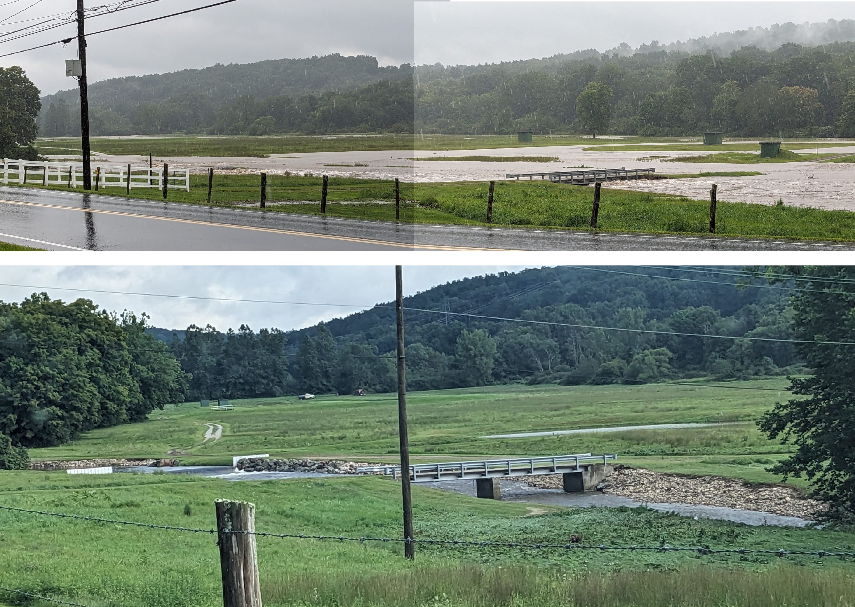
Almost all of the remnants of the weir were destroyed by a 2024 flood on the 69th anniversary of the Great Flood of August 18-19 in 1955: https://wakinguponturtleisland.blogspot.com/2024/08/the-one-in-thousand-flood-nonnewaugct.html
See also:

https://wakinguponturtleisland.blogspot.com/2024/10/more-of-final-days-of-nonnewaug-fish.html
Saturday, October 19, 2024
The Friends of Pine 2024 Fall Program is well underway with more to come.
The Friends of Pine 2024 Fall Program is well underway with more to come.

But first, a reminder that tonight, Friday, October 18, the Littleton Lyceum is presenting :
Littleton’s Hidden Sacred-Shamanic Landscape: Sacred Stones, Vision Quest, and the Nashobah Praying Indians with Sagamore of the Nashobah Praying Indians, Strong Bear Medicine, and Littleton historian Daniel V. Boudillion at 7:30 PM.
Upcoming Pine Hawk Programs
Full descriptions of these programs are on our website https://www.pinehawk.org/2024-
All Pine Hawk events are free but require registration at tinyurl.com/pinehawk-2024.
Burying the Trowel: A History of Controversy and Innovation in New England’s Cultural Stone Features Debate
Tuesday, October 22, 7-8:30 PM in person at the Acton Memorial Library and via Zoom
Cultural anthropologist Kitty O’Riordan will make sense of contributions, clashes, and collaborations between avocational researchers and professional archaeologists in pursuit of understanding the unusual stone features that dot the woodlands and hillsides of New England.
Changes in the Land Book Discussion
Tuesday, October 29, 7-8:30 PM in person at the Acton Memorial Library
All are invited to this in-person group discussion of William Cronon’s landmark environmental history of pre- and post-contact New England.
Community Service Day
Sunday, November 10, 1-3 PM in person
Assist with trail and site maintenance on the Nashoba Brook Conservation Land’s Trail Through Time, a multicultural heritage trail in North Acton. There will be an optional brunch beforehand at 11:30 am. Limited to 25, ages 13 and up. Details will be emailed to registrants a few days in advance.
Adult Archaeology Walk
Saturday, November 9, 10AM–noon, in person only. (Note new date)
Ian Bergmann, Land Stewardship Coordinator for the Town of Acton, will lead this hike along the Nashoba Brook Trail, with stops at the stone chamber and Native American ceremonial sites. Trail conditions can be rocky, uneven, and often wet, and thus participation is limited. Registrants will receive a detailed email several days before the walk. Limited to 20, ages 17 and up. (Previously scheduled for Oct. 19.)
A Day in the Life of a Local Archaeologist
Wednesday, November 20, 7 PM, in person at the Acton Memorial Library and via Zoom
Westford archaeologist David Gutbrod will share experiences and discoveries encountered in his professional life, from remote sensing projects in the South to an extensive report on a significant site in North Acton.
Native Americans and the Revolution: The Times are Exceedingly Altered
Thursday, December 5, 7 pm, at Acton Town Hall and via Zoom
Historian Daniel Mandell, author of Tribe, Race, History: Native Americans in Southern New England, 1780-1880, will present how the thousands of Native people in southern New England were involved in and impacted by the Revolution, and how they sought to secure their rights in different ways. Cosponsored with Acton 250.
For full descriptions of these free programs and to register, visit the Pine Hawk website at https://www.pinehawk.org/
The Friends of Pine Hawk 2024 Programs are presented with support from Acton Memorial Library and Freedom’s Way National Heritage Area.
Thursday, October 17, 2024
Jennison Rd - Shutesbury
[Reader Nicholas writes:]
I travel all over New England for work, and try to make it a point to have my rest-stops be in the area of some known stone site, chamber, local legend.
I made a stop last time in Shutesbury to visit the splendid Monk’s Chamber. Always happy to spend some time in there!
I left the chamber and began my ride on Jennison road, heading into Wendell. I was taking it slow and was able to spot a curious arrangement of stone about 30 ft off of the dirt road. A large farm was down the road a bit, but otherwise a sleepy and forgotten pasture was the only neighbor.
There were quite a few arrangements in fact, some bearing striking resemblance to other sites I have been to. It being so close to the Monk and Ames chambers, I figured it worth documenting a bit!
Happy Wanderings!
-Nicholas


Thursday, October 10, 2024
Goat Hill - Uxbridge, MA

Reader Stacey writes:
I came across your blog when trying to find info about the stone structures that I’ve seen on Goat Hill in Uxbridge. I go hiking in this area often and nearly every time I see something I hadn’t noticed before. Here is a link with just some of the photos I’ve taken recently:
Some info about the area: the hill overlooks the Blackstone River with Wolf Hill and Lookout Rock to the northeast on the other side of the river. Lookout Rock is said to have been used by Native Americans to oversee the valley. Goat Hill is deposited with huge glacial erratics and a ton of quartz. The eastern slope of the hill was utilized for the Blackstone Canal and towpath, but I don’t think the features on the upper terraces and the western/southern slopes are as modern as the canal. All throughout the area are old stonewalls (that look to vary in age and construction), cairns, rock piles, split boulders, rock shelters, manitou stones, and effigies. Many of these features seem to be “connected”, either in close proximity to one another or physically connected by stone walls.
The photos are really just a tiny portion of what’s there and I’m surprised I can’t find much online about it. If you haven’t explored this area, I think you would find it really interesting and would love to hear what you think. I think the photos have the location info attached, but I also have a map in CalTopo that I’ve marked the locations of some of the features.
Pine Hawk: "New England Archaeological Discoveries" & more

Wed. Oct 9 "Archaeological Discoveries in New England"
Tues. Oct 15 "Ancient Winters at the Flagg Swamp Rockshelter"
Sat. Oct 18 Adult Archaeology Walk
Presented with support from Acton Memorial Library and Freedom’s Way National Heritage Area, events are free but require registration at tinyurl.com/pinehawk-2024
Thursday, October 03, 2024
Sacred Stones, Vision Quest, and the Nashobah Praying Indians
[From Dan Boudillion]
Sacred Stones, Vision Quest, and the Nashobah Praying Indians
Dear Friends of the Nashobah Praying Indians!
Strong Bear Medicine and the Prayers in Stone Project Ceremonial Stone Landscape team will be presenting at the Littleton Lyceum on Friday, October 18, 2024 at 7:30 pm. The venue is the Littleton High School Auditorium located at 56 King Street, Littleton, MA.
You will need to buy tickets for this event and can do so online:
https://www.littletonlyceum.
Here is the full description of the presentation:
Littleton’s Hidden Sacred-Shamanic Landscape:
Sacred Stones, Vision Quest, and the Nashobah Praying Indians
Presented by the Prayers in Stone Project founders and Littleton residents: Sagamore Strong Bear Medicine & Historian Daniel V. Boudillion.
Littleton is sacred ground. We walk and live amongst a Native-made Spirit-dwelling landscape, a shamanic-world hidden just out of sight, set aside in 1654 by the Nashobah Praying Indians to preserve this sacred place. Journey with us as we explore a world of ceremonial stone constructions, from antiquity to modern times, hidden all around us: prayers to Creator built of stone, spirit summoning enclosures, vision seats, spirit portals, manitou stones, solstice sunrise welcoming sites, sacred turtle effigies, serpent rows, and earthen dance-rings to name a few. Tread softly here, this landscape lives, and is a place of communion between the Great Spirit and the human spirit.
Strong Bear Medicine is the Sagamore of the Nashobah Praying Indians and spiritual custodian of these ancient sacred sites. Daniel V. Boudillion is a Littleton historian, author, and sacred sites visionary.
Link to Littleton Lyceum ticket sales:
https://www.littletonlyceum.
Looking forward to seeing you all, presenting new information about our Native sacred landscape, and introducing the Prayers in Stone Project team!
Saturday, September 14, 2024
Nolumbeka Project announcement
Marge Bruchac and Dan Shears in Turners Falls September 14. Click Here for Details
Friday, September 13, 2024
Shadows on the Stone (Woodbridge CT)
At Just the Right Moment

Are those marks made with the "stone/bone/horn/wooden
Indigenous tools" from pre contact times, or were they made with post
contact European steel stone masonry tools?
I can answer that
question very quickly: "I don't know."

Special thanks to Yehuda Jay Wolkoff for capturing the image
and allowing me to use it here!
More here: https://wakinguponturtleisland.blogspot.com/2024/09/waking-up-on-turtle-island-again.html
Friday, September 06, 2024
Mike Luoma's Video Series
Mike gave me shout-out in this video.
Much appreciated. Nashoba Brook is where we all cut out teeth on the subject.
Natick Powwow - Sept 28
[More from Dan Boudillion]
Dear Friends of the Nashobah Praying Indians,
We are happy to announce that the Praying Indians will be holding their annual Powwow in Natick on September 28 of this month.
Please see flyer, attached. We look forward to seeing you there!

Best wishes,
Dan Boudillion
Secretary
Friends of the Nashobah Praying Indians
Friday, August 30, 2024
Event: Strong Bear Medicine talk in Acton 9-17-2024
[From Dan Boudillion:]
Dear Friends of the Nashobah Praying Indians,
Please support Strong Bear Medicine who will be speaking in Acton on 9-17 at an event sponsored by the Sudbury Valley Trustees.
We are looking forward to partnering the SVT on this important talk. It is the first time Strong Bear has presented in Acton.
See flyer, attached.
Registration required, see flyer, or here: https://www.svtweb.org/
Thursday, August 29, 2024
An article about Canonchet and Rock Piles in General
I was impressed with this very thoroughly written article by Karen Ellsworth. It is about events in 2017.
A Mystery at Canonchet: Who Built the Stone Piles in...
But to me, reading it, there is an elephant in the room: Most of the people commenting on rock piles and the social impact of one or another interpretation, have seen maybe 1/20th of the data available in a short, couple-hour's drive. And they pay the price, I'll explain.
The writer is discussing how to "identify" a rock pile as Native American. And I come off as a bit of a scoundrel because I'm quoted saying that the Indians did not really know about these things a few years ago. But that doesn't mean the Indians aren't right. It also doesn't mean that "Indian-vs-European" is a valid dichotomy in discussing piles that are often from that post-colonial, historic period.
The point I want to make is that if commenters on rock piles knew these things, and had seen 20x what they had already seen, they would know: You recognize an old friend when you see them. It's not complicated. It helps if you have a clue as to a place's function. I'm sorry, but making the ethnic authorship issue the highest priority, just shows your amateurishness. What is important is site design. I think it is the direction to look for answers.
I try to be supportive of alternate views, but the characters quoted in the article are mostly the worst proponents of a complex subject - they are front and center, making a lot of noise, making money doing it, and speaking as experts when they are not.
Monday, August 26, 2024
A Stone Chamber in Mason NH
[Reader Nicholas writes:]
My good friend who lives in Mason, NH has caught intrigue from my infatuation with stone sites. He sent me these photos from a site 5 minutes from his house.
.jpeg)

.jpeg)
.jpeg)
Haven’t been able to go get a good look at it, but 6’ high, about 20’ long and it seems to taper off. It’s a beaut of a chamber whatever period it’s from!
Just wanted to share, best wishes
-Nicholas Phelan
Wednesday, August 21, 2024
Thursday, August 08, 2024


Wednesday, August 07, 2024
Those "hobbit" fossils from Flores
[Not rock pile related]
This article shows that the small hominid fossils from the Isle of Flores in the Pacific, were not examples of "island dwarfism", as they have now found more fossils, even older than the original find, and the older fossils are of a smaller species.
Let's take a moment to consider the implications. The first is that this is a branch of the human tree the split off the main "trunk" before Homo Erectus. That means earlier species were able to make the voyage. That means world-wide distribution much earlier than believed.
Friday, July 26, 2024
Prayers in Stone Project

Prayers In Stone Project
Native Sites Stewardship Program
Founded 2024 Sagamore Strong Bear Medicine & D.V.Boudillion
How do you know?
26 July 2024 Daniel V.
Boudillion
Several years ago I was at a Friends of Pine Hawk lecture on Native stone structures by two recognized experts in the field. At one point while they were interpreting a type of stone structure, an audience member asked “But how do you know that?” Much to the dismay of all there that night, they were unable to answer this question.
This awkward situation left an impression on me. It’s a question I often ask myself as I walk the woods and assess stonework as Native: “Yes, but how I know?”
This essay is not to answer this question, but to provide an illustration of people creating structures in the woods that resemble Native type structures, but are not. It’s a cautious call to caution.
On the recent Prayers in Stone survey of the local forestry property, I noticed some trees had been cut next to the forestry barn, and the wood left stacked there.
I was intrigued because the wood was piled in a way – that were it stone and not wood – would likely have elicited a Native ceremonial origin assessment from me.
It illustrates that people pile things, often in the woods, in a manner that closely resembles the structures that we typically assess as Native-origin, ceremonial in nature. If modern people can pile wood in a way that exactly resembles – were it in stone – constructions we would call Native, they can also pile stone as well in ways that look Native but are not.
Which beings me back to the question: How do we know?
Please see below pictures of the “ceremonial” wood stacking.

Log pile 1 Log pile 2

Stick pile All three piles in view

At the forestry barn large cut logs are stacked in a deliberately constructed pile on a boulder, much like these large rocks stacked on a boulder at Trails Through Time.

These smaller “donation” sticks have been placed in a split rock at forestry barn. This is much like the picture to the right of small donation stones placed in a large split rock.

Here we have two large log lengths perched on a boulder in classic “rock-on-rock” style, as exemplified by the picture to the right.
 The picture to the
left is of all three log pile constructions.
It has everything we look for: a variety of recognized styles, they are
in a cluster, and the cluster is within an enclosure of stone rows. Were this stone on stone, not wood on stone,
we would assess it as Native.
The picture to the
left is of all three log pile constructions.
It has everything we look for: a variety of recognized styles, they are
in a cluster, and the cluster is within an enclosure of stone rows. Were this stone on stone, not wood on stone,
we would assess it as Native.
But its not Native. This is the point, its not Native. People pile things on boulders for a variety of reasons. This is a perfect example. Keep this in mind the next time you are working on assessments.
Be cautious.
Like the fellow said: “How do you know?”
Subscribe to:
Posts
(
Atom
)
