
Monday, December 31, 2007
Hiking in Isle Royal National Park
Kind of interesting account:
"passed through a double rock cairn, one on each side of the "path." But of course, there really was no path up there - only stone, and fresh moss everywhere.
"passed through a double rock cairn, one on each side of the "path." But of course, there really was no path up there - only stone, and fresh moss everywhere.
But what a view! We were definitely on the highest point of the ridge so far, maybe the highest point of the whole Minong Ridge Trail, even. Superior was close down to the north, and Canada wasn't far behind it. To the south we could see the Greenstone ridge rambling up & down to the east and west. It wasn't long before we'd had enough of the scenery; the rain was whipping in our faces, and anywhere the rain didn't get to, the bitter wind was happy to oblige, so we figured we better keep moving. But where? We spied another cairn in the distance, so we headed towards it. After that, we saw another. Funny thing, though - this rock pile was perched on the brink of a ledge, with no path going down that we could see."
Sounds like the cairns might not have been marking a trail.
A thorough article about North Smithfield RI's threatened rock piles.
I always thought rock piles might play a role in supporting tribal recognition. Here the idea comes out. This is perhaps the most descriptive article I have seen about North Smithfield and the threatened rock piles there.
Towards the end of this [Click here] appears:
"If the stone piles could be shown to be Wampanoag-built memorials, that could be solid evidence — literally — of the tribe’s existence in the area."
Ooh! Ooh! Ooh! Look at this quote...what'd I tell you?
"One of the piles has a large quartzite stone in it. Germaine said that could mean it marks the grave of an important person, such as Nimrod, one of Philip’s chief lieutenants who died in the first Nipsachuck battle."
Update: This appears in a comment to this post from reader "Don".
"Dr. Meli has done an outstanding job for our commission and the town. He put his extensive reputation on the line by indicating that this site was not merely 'field clearing by colonists'. He then set about to prove his beliefs and convictions and in the end, he did just that.
While I cannot reveal where it is exactly or the what has been located, I can assure all who have an understanding of our amazing Native American culture and history, that preservation and protection of this incredible site is assured."
Archeological Services, Inc.
Salvage archeologists. Their awareness of rock piles may stem from their being Canadian.
[Click here]
[Click here]
Some cairns spared in subdivision plan
From the Clinton Reporter. This is about Killingworth CT[Click here]
I cannot quite get the numbers, as they seem to be changing the meaning of "cairn" on the way through the article. Anyway this appears to be the latest, dated Dec. 31 2007.
Sunday, December 30, 2007
Moments of self doubt
The other day I took FFC out to see a site I know and I was pointing out the sense of terracing, with lines running in the same directions as the lines between rock piles. 
 He thought this was good evidence of this having been an orchard. And then I am thinking that the even spacing of trees in an orchard would be a good explanation of the phenomenon of grid-like arrangements of rock piles. And does this throw the whole theory of marker pile sites into doubt?
An answer is that this site bears a close resemblance to a number of other sites where there is less or perhaps no possibility of an orchard. So the burden of proof would need to lie with those suggesting the piles are from having an orchard. FFC, clever, points out that you would never put rock piles underneath apple trees cuz that would mash the apples when they fell. Here, this captures the place in the snow. Every bump is a rock pile and you can see the terraces.
Here is FFC looking in the direction of the lines and terraces. Rosie the dog is a beloved companion. At this site, everything points down the valley towards the southwest. This knoll has water on both sides.

 He thought this was good evidence of this having been an orchard. And then I am thinking that the even spacing of trees in an orchard would be a good explanation of the phenomenon of grid-like arrangements of rock piles. And does this throw the whole theory of marker pile sites into doubt?
 An answer is that this site bears a close resemblance to a number of other sites where there is less or perhaps no possibility of an orchard. So the burden of proof would need to lie with those suggesting the piles are from having an orchard. FFC, clever, points out that you would never put rock piles underneath apple trees cuz that would mash the apples when they fell. Here, this captures the place in the snow.
 Every bump is a rock pile and you can see the terraces.
Here is FFC looking in the direction of the lines and terraces. Rosie the dog is a beloved companion.
 At this site, everything points down the valley towards the southwest. This knoll has water on both sides.
Saturday, December 29, 2007
Weather report
Well there are still 9-12 inches of slush on the ground. After rain and fog, the ~18 inches of snowcover has been significantly reduced. I was hoping maybe tomorrow I could get out and look around. Yesterday I went out and got quickly tired of punching through the crust every four or five steps. But I do think that rocks and such have begun to emerge from the snow and are visible if you can get out to them.
Update: I was wrong on both counts. The snow has still not consolidated enough to walk on the crust and, making the effort to get to one site I know nearby, I could not see any reasonable visual evidence that there were rock piles there.
Update: I was wrong on both counts. The snow has still not consolidated enough to walk on the crust and, making the effort to get to one site I know nearby, I could not see any reasonable visual evidence that there were rock piles there.
Friday, December 28, 2007

Tuesday, December 25, 2007
Ancient Petroglyphs lie amongst suburban sprawl
This is not rock pile related but rings a sympathetic chord for me. Rock piles around here should be so lucky as these petroglypsh. There are also even better solutions.
[Click here]
[Click here]
Monday, December 24, 2007
Round Hill - Sudbury, MA From 2005 Journals
I proposed going back to old Journal entries to fill in some of the slow times when snow is on the ground. Forthwith....this is from Jan 15, 2005.
Then a warm rain washed the snow away and I got one short morning of exploring. I want to explore down in Sudbury and along the lower part of the "Maynard Quadrangle". Today I saw a gully just south of White Pond in Concord I thought I should explore - I did without seeing anything. Then I investigated one hill south of the there and it is too private, and one more hill further south again called "Round Hill" and part of the Sudbury Conservation Land did have a few minor hints of stuff on it.
First off the large stones and loose wall caught my attention near the southwestern shoulder and it seemed at this end to terminate in a platform pile which, as typical, could also be a field clearing pile.
 There was a fine view from up top which was a pretty bare hilltop. A bench to "Richard Forster - Naturalist" sits next to the loose wall and looks out to the south. The wall continues over towards the eastern side where, in a connected wall, there seems to be a stone "U" looking southeast.

 My attention was drawn to the "U" because previously all the rocks in the wall had been large and spaced out. Here all of a sudden was a concentration of smaller rocks closer together. Looking closer I saw that what looked like a little corner in the wall actually was leading nowhere, so I conclude it might have been a "U" incorporated deliberately into the wall. On the north east of the summit there were a couple of possible rock piles and maybe a bit more on the northern slope of the hill too.
 All these vestiges are merely possible rock piles. Nothing definitive but just hints of what might have been there before. Someone needs to go check out the one main stone wall and see if it aligns with anything.
Then a warm rain washed the snow away and I got one short morning of exploring. I want to explore down in Sudbury and along the lower part of the "Maynard Quadrangle". Today I saw a gully just south of White Pond in Concord I thought I should explore - I did without seeing anything. Then I investigated one hill south of the there and it is too private, and one more hill further south again called "Round Hill" and part of the Sudbury Conservation Land did have a few minor hints of stuff on it.
First off the large stones and loose wall caught my attention near the southwestern shoulder and it seemed at this end to terminate in a platform pile which, as typical, could also be a field clearing pile.

 There was a fine view from up top which was a pretty bare hilltop. A bench to "Richard Forster - Naturalist" sits next to the loose wall and looks out to the south. The wall continues over towards the eastern side where, in a connected wall, there seems to be a stone "U" looking southeast.
 My attention was drawn to the "U" because previously all the rocks in the wall had been large and spaced out. Here all of a sudden was a concentration of smaller rocks closer together. Looking closer I saw that what looked like a little corner in the wall actually was leading nowhere, so I conclude it might have been a "U" incorporated deliberately into the wall. On the north east of the summit there were a couple of possible rock piles and maybe a bit more on the northern slope of the hill too.
 All these vestiges are merely possible rock piles. Nothing definitive but just hints of what might have been there before. Someone needs to go check out the one main stone wall and see if it aligns with anything.
Sunday, December 23, 2007
Saturday, December 22, 2007
Some pictures for a snowy day
More snow on the ground with little hope for exploration. Let's at least have a couple of rock pile pictures from two weeks ago to look at.

A few scattered things from the north end of the Hill of 500 Cairns.

 In this last picture you can see some traces of rock piles in the middle-distance behind. This is the last alignment I showed the other day [Click here and see last photo].
I hope this gives a bit of a feel for the place.


A few scattered things from the north end of the Hill of 500 Cairns.

 In this last picture you can see some traces of rock piles in the middle-distance behind. This is the last alignment I showed the other day [Click here and see last photo].
I hope this gives a bit of a feel for the place.
Thursday, December 20, 2007
FYI - The Archeological Conservancy
[Click here]
Someday, these guys may be the ones who pay to preserve some of the sites in New England. We just need to distract them from the Southwest.
Someday, these guys may be the ones who pay to preserve some of the sites in New England. We just need to distract them from the Southwest.
Stone Walls and Cellar Holes - guide to structures in the Vermont Woods
Here the conventional view is expressed: [Click here (warning pdf)]
Stonewatch - Newsletter of the Gungywamp Society
If you haven't seen this before, take a look [Click here]
Tuesday, December 18, 2007
Foreign Languages and Our Stones
Geophile
Received a lot of links by email about seid or seida stones in the last week, and many were very interesting. However, two really caught my eye and I thought them worth sharing with people here, if only to show that awareness of the stone sites of the northeastern U.S. is spreading.
The first was taken directly from the Stone Structures site, except that it is in Russian. The second is in Finnish, and boy do I wish Babelfish translated that language, but for now I can just admire how it looks. I may as well post a third link, not showing any American stones, but some very like them. Check out the platform cairns in the lower half of this page. And a fourth--because the stones look pretty nice as you get up into the regions of Santa's workshop. Here's wishing everyone a happy solstice, merry Christmas, or just a joyous holiday season!
An small map from Norman Muller
Look at this (click here) which is from this http://rock-piles.com/R7-2/page3.html
This looks a bit like a marker pile site. Imagine sitting on the boulder.
Update: or imagine sitting in the "grotto".
This looks a bit like a marker pile site. Imagine sitting on the boulder.
Update: or imagine sitting in the "grotto".
Really bad conditions for going out photo-ing things
There is a crust over about 1.5 feet of snow. It is hard to walk in and impossible to see underneath. So even if I felt like going out to take photos in the snow, it would be too strenuous. This would be a great time for one of you from warmer climes or warmer times to send in some photos.
Wall Embrasure - Bolton MA
I am pretty sure this is deliberate. It is from the northern slopes of the "Hill of 500 cairns".  A few feet away:
 A few feet away:

Monday, December 17, 2007
Re-visiting the edges of "The Hill of 500 Cairns"
I wrote about this hill previously [Click here and more generally here]. A couple of weekends ago I was going to go on a long drive to explore in Southborough and passed this Hill of 400 cairns (or 500 cairns) on Rt 495 and thought: "I should really go explore more around the northern edge of the hill". Then I realized that that was a better prospect than the one I was headed towards, so I changed plans. Last time at this hill with a group of people, we walked up to the top from the southwest, starting at the end of Whitcomb Rd in Bolton. This time, instead of climbing the hill, I stayed as far west as possible, following the deer fence along the highway and stayed at the foot of the hill. This should have taken me right down to the edges of the part of the site that was destroyed by the highway. In fact there were rock piles right up to the deer fence:  And some really pretty little things under the thin crust of snow:
 Although we are told that the destroyed site contained wondrous things (large cairns of limestone, with blocks cemented together from age) there is no reason today to suspect that that part of the hill was much different from here, 50 yards away. I cannot find a single piece of limestone, nor any very substantial cairns.
I can't escape the feeling that this hill consists of a large collection of different "grids". The notion of a site extended at many different times seems to fit this place well. And I cannot help but get a sense of lined up piles here. But it is hard to show. Here is the basic westward facing slope, with one line of rock piles after another running down the slope in parallel; but you cannot really see them: In another part of the hill, the line is un-mistakable, here are four or five in a row:
 Wondrous enough.
 And some really pretty little things under the thin crust of snow:
 Although we are told that the destroyed site contained wondrous things (large cairns of limestone, with blocks cemented together from age) there is no reason today to suspect that that part of the hill was much different from here, 50 yards away. I cannot find a single piece of limestone, nor any very substantial cairns.
I can't escape the feeling that this hill consists of a large collection of different "grids". The notion of a site extended at many different times seems to fit this place well. And I cannot help but get a sense of lined up piles here. But it is hard to show. Here is the basic westward facing slope, with one line of rock piles after another running down the slope in parallel; but you cannot really see them:
 In another part of the hill, the line is un-mistakable, here are four or five in a row:
 Wondrous enough.
Friday, December 14, 2007
Snow no rock piles
Now that there is about 1 foot of snow on the ground here I have the perfect excuse for sitting around and having a lazy weekend. I know from past efforts that hunting for new rock piles in the new snow is very difficult. It is hard enough locating piles you already know about.
So I'll be kicking back and reporting on last weekend's site visits, which I didn't get around to this week. And in a pinch we can take a look at some old site photos from past Journals.
Update:
Compared with the attitude last year [Click here], maybe it is worth going out anyway.
So I'll be kicking back and reporting on last weekend's site visits, which I didn't get around to this week. And in a pinch we can take a look at some old site photos from past Journals.
Update:
Compared with the attitude last year [Click here], maybe it is worth going out anyway.
Thursday, December 13, 2007


Wednesday, December 12, 2007
Vottovaara
Geophile
 Photo by Dmitry Bulavinov
Received an email about this spot in Russia near its border with Finland and after learning a little I thought people here might be interested in it. Fascinating place.
From one website: "Mountain Vottovaara is a sacred place of ancient Saami people. Approximately 1600 sacred stones called “seids” are arranged here in a mysterious order.
The cult complex occupies about 6 sq. km and comprises stone boulders of different diameter from 30 cm up to 1.5 meters. They are situated in groups of 2-6 usually forming a circle.
 Photo by Dmitry Bulavinov
From one website: "Mountain Vottovaara is a sacred place of ancient Saami people. Approximately 1600 sacred stones called “seids” are arranged here in a mysterious order.
The cult complex occupies about 6 sq. km and comprises stone boulders of different diameter from 30 cm up to 1.5 meters. They are situated in groups of 2-6 usually forming a circle.
The connection between the stone's location and the surrounding landscape can be sensed distinctly. Some boulders have signs of human effect. Some of them weighing almost a ton are placed on smaller stones as if on legs or smaller stones are placed on top of them. They also have signs of their intentional placement in certain places, usually in high sections of the rock closer to other stone accumulations. Meanwhile archeologists haven't found any evidence to state an exact date of the creation of seids."
It is threatened by mining operations, and if you're interested, a petition to save it is here, with more pictures here and here.Tuesday, December 11, 2007
Nothing to report. Taking a break.
Last weekend I did not see any new rock pile sites and so I have little to report. Feel like taking a bit of a break anyway.
Sunday, December 09, 2007
Martin Gray's "Sacred Earth"
(Advertisment - perhaps a christmas gift for someone)
The Most Definitive Work on Sacred Sites Ever Compiled
25 Years in the Making...Over 80 Countries and 1,000 Sacred Sites
The Most Definitive Work on Sacred Sites Ever Compiled
25 Years in the Making...Over 80 Countries and 1,000 Sacred Sites
Acclaimed photographer and anthropologist Martin Gray has spent the last twenty years on a pilgrimage photographing and exploring more than a thousand sacred sites in eighty countries. Now, this stunning beautiful and deeply rewarding book conveys the essence of this remarkable journey to locations and sites imbued with the power to awaken feelings of transcendence, awe, and peace.
Imbued with Historical Luster and Spiritual Magnetism
In these pages we not only visit, but find ourselves deeply immersed in our worlds most venerated and visited sites, including the ruins of Delphi, the supreme oracle site of the ancient Mediterranean; the Ka'ba at the Great Mosque at Mecca, birthplace of the prophet Mohammed; the great temple complex of Angkor in Cambodia, one of humankind's most astonishing architectural achievements; Machu Picchu, the secret ceremonial city of he Incas located high in the Andes; and New Mexico's White Sands, a place of shimmering beauty that was once a fabled site for the vision questions of Native Americans, to name but a few.
Accompanying each photograph is an insightful commentary that takes us deep into the history, mythology, and spiritual magnetism of the particular place. We come to realize that these stone rings, pyramids, shrines, and temples are often situated in locations that were discovered to possess special powers and energies by pre-industrial peoples who recognized the earth as a living and sacred being worthy of deep respect.
-- excerpted from the foreword, by Graham Hancock
About the Author...
Martin Gray is a photographer and anthropologist whose work has been published by the National Geographic Society. During the past fifteen years, he has presented slide shows on the extraordinary beauty and precarious situation of the world's sacred sites to more than one hundred thousand people on four continents. His award winning website, www.sacredsites.com has received over twenty million visitors since 1998. Sacred Earth is featured in a major Feng Shui journal. |
| Exclusive Collectors Autographed Copy, Order Now for $45, and Save $20. A Great Holiday Gift! 276 illustrated pages of shimmering beauty |
Saturday, December 08, 2007
Pegan Hill - Natick, MA
Last week Jim P. asked, in email, if I had ever been to Pegan Hill in Natick. I hadn't but, prompted by his question, went to look for it on a topo map and found what looked like a place worth exploring. Jim thought it might be especially worthwhile because it is the highest point in Natick and was once a southern boundary of the Natick Praying Indian Village. We have had good luck finding rock ple sites by exploring places associated with the Praying Indian Villages. Certainly some of the hills around the Nashoba Praying Indian Village are among the best places to look for rock pile sites; so I decided to go out at the first opportunity. Also this hill is within a slow bend of the Charles River, so it would have been visible and accessible in the past.
When I got there, I read the Trustees of Reservation Interpretive signs and found that the hill had probably been burned clean of trees and undergrowth in the past.
 Today the hill has a uniform, low density of oaks and some pines, with little or no underbrush. As I walked along, zig-zagging gradually up the hill from the north, it was mostly just the brown of dead leaves underfoot. This made the bright gray of the occasional rock all the easier to see. So I kept on the lookout. I went up towards the top expecting and hoping to see something on the western facing side. But when I got up there all I could see was a few scattered rocks. In one place three in a row lined up and I have no doubt this was a deliberate alignment:
 The direction is roughly southwest. I would have walked further in that direction but private properties are close by on that side of the hill.
I got to the top, a very flat and gradual affair with a surveyors mark at the approximate high point. (On the map you can see the hilltop is near the corner of Middlesex County, my favorite county.) Then I continued exploring around the summit as carefully as I could. It did not look like I was going to find much and I was walking along a bit of trail up there, keeping my eye on one little bit of gray that looked like it might have a shadow underneath it, as in rock-on-rock, and then there was a bump next to the trail with several small rocks sticking out from the dead leaves.
 And this was a first rock pile and the gray with shadow I had been watching was a second one a few feet away.
  There is a barren beauty to the spot. The Indians chose beautiful places.
In a funny way these piles were what I would expect of the Charles River water shed. They are larger piles, and made from largish rocks. But they are all broken down and it is hard to guess what they might have once looked like.
I was wondering what else might be in the immediate vicininty, looking around carefully, and wondering why the rock piles would be here instead of there. A few yards further on the trail I spotted another rock pile next to the stone wall,
 and it was near a smaller pile too.
 [The larger pile is visible in the background. Note the shape of this smaller pile. It is a lot like the one we saw a few days ago as the first picture in "Three in a row with turtle" [Click here], possibly a coincidence of both piles haveing five rocks.]
And now I could see a possible reason why the piles were here instead of there. They were placed at the very highest point of a gully the leads down from the summit towards the south. The gully develops into a valley which, today, is a driveway. In fact there were some other damaged piles on the far side of the stone wall, just above the driveway, probably on private land.
 Since these other ones could be part of the same site, it suggests the stone wall might be a more recent addition. In any case that was the scope of this small site along the trail on the southern side of the summit of Pegan Hill - perhaps four mid-sized, damaged, ground pile and one small pile, all placed at the beginning of the water flow from the hill.
Later on my way down the hill to the east, I found one more pile in a different context but that was all I could find on Pegan Hill.
 Jim thought it might be especially worthwhile because it is the highest point in Natick and was once a southern boundary of the Natick Praying Indian Village. We have had good luck finding rock ple sites by exploring places associated with the Praying Indian Villages. Certainly some of the hills around the Nashoba Praying Indian Village are among the best places to look for rock pile sites; so I decided to go out at the first opportunity. Also this hill is within a slow bend of the Charles River, so it would have been visible and accessible in the past.
When I got there, I read the Trustees of Reservation Interpretive signs and found that the hill had probably been burned clean of trees and undergrowth in the past.
 Today the hill has a uniform, low density of oaks and some pines, with little or no underbrush. As I walked along, zig-zagging gradually up the hill from the north, it was mostly just the brown of dead leaves underfoot. This made the bright gray of the occasional rock all the easier to see. So I kept on the lookout. I went up towards the top expecting and hoping to see something on the western facing side. But when I got up there all I could see was a few scattered rocks. In one place three in a row lined up and I have no doubt this was a deliberate alignment:
 The direction is roughly southwest. I would have walked further in that direction but private properties are close by on that side of the hill.
I got to the top, a very flat and gradual affair with a surveyors mark at the approximate high point. (On the map you can see the hilltop is near the corner of Middlesex County, my favorite county.) Then I continued exploring around the summit as carefully as I could. It did not look like I was going to find much and I was walking along a bit of trail up there, keeping my eye on one little bit of gray that looked like it might have a shadow underneath it, as in rock-on-rock, and then there was a bump next to the trail with several small rocks sticking out from the dead leaves.
 And this was a first rock pile and the gray with shadow I had been watching was a second one a few feet away.
  There is a barren beauty to the spot. The Indians chose beautiful places.
In a funny way these piles were what I would expect of the Charles River water shed. They are larger piles, and made from largish rocks. But they are all broken down and it is hard to guess what they might have once looked like.
I was wondering what else might be in the immediate vicininty, looking around carefully, and wondering why the rock piles would be here instead of there. A few yards further on the trail I spotted another rock pile next to the stone wall,
 and it was near a smaller pile too.
 [The larger pile is visible in the background. Note the shape of this smaller pile. It is a lot like the one we saw a few days ago as the first picture in "Three in a row with turtle" [Click here], possibly a coincidence of both piles haveing five rocks.]
And now I could see a possible reason why the piles were here instead of there. They were placed at the very highest point of a gully the leads down from the summit towards the south.
 The gully develops into a valley which, today, is a driveway. In fact there were some other damaged piles on the far side of the stone wall, just above the driveway, probably on private land.
 Since these other ones could be part of the same site, it suggests the stone wall might be a more recent addition. In any case that was the scope of this small site along the trail on the southern side of the summit of Pegan Hill - perhaps four mid-sized, damaged, ground pile and one small pile, all placed at the beginning of the water flow from the hill.
 Later on my way down the hill to the east, I found one more pile in a different context but that was all I could find on Pegan Hill.
Friday, December 07, 2007
Montezuma Castle & Well (not rockpile related)
by JimP
 I was in Sedona on business this past summer and had an opportunity to stop along the way at both Montezuma Castle and Montezuma Well National Monuments (both erroneously named after Montezuma). The castle is built into the side of a high cliff -- a marvel of ancient engineering. Sinagua ruins can be seen at the base of the cliff. Likewise, ancient stone ruins can be found at Montezuma Well, along with a 1,000-year-old canal that still works flawlessly.
There are three pages of thumbnails. The last page features just scenic shots of Sedona.
[CLICK HERE] for the photo gallery.
Thursday, December 06, 2007
A bend in the brook
My guide took me down to a bend in Elizabeth brook where there was a knoll and a drop-off with sparse underbrush down to the water - which was shining bright in the sunlight. There were rock piles. 
 It was good to see a new site. It seemed that several of the piles had one larger "head" rock facing the water
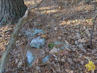
 If I may be allowed a poetic moment, no jewels could be so bright or colorful as this view:
 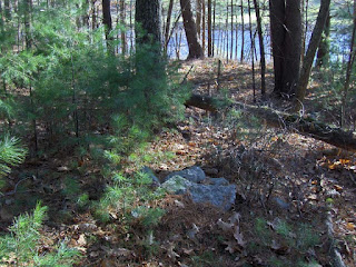 Further back, still other piles:
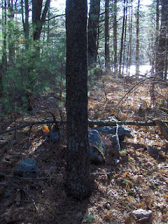

 It was good to see a new site. It seemed that several of the piles had one larger "head" rock facing the water
 If I may be allowed a poetic moment, no jewels could be so bright or colorful as this view:
  Further back, still other piles:
Three in a row with a turtle
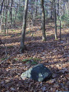
My guide took me to small rock pile next to a big cedar tree. 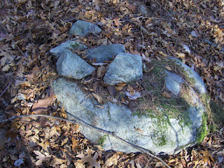 The pile was isolated, out of context. But then we saw another pile across the hill a bit, so I realized the first was not completely isolated.
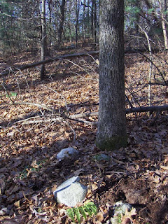 (You can see the first pile in the background beyond the fallen tree.)
Then we came to what my guide called a "big rock on little rock". Followers of the turtle will make note of this.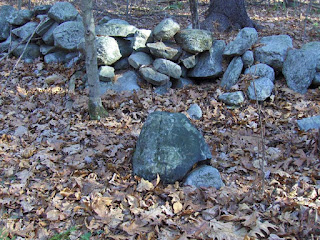
 But then looking back towards the previous piles I realized that all the structures were exactly in line with each other. You can make out all three in this picture.
 So imagine a framework in which a turtle would have some function within an alignment of three objects like this.
 The pile was isolated, out of context. But then we saw another pile across the hill a bit, so I realized the first was not completely isolated.
 (You can see the first pile in the background beyond the fallen tree.)
Then we came to what my guide called a "big rock on little rock". Followers of the turtle will make note of this.

 But then looking back towards the previous piles I realized that all the structures were exactly in line with each other. You can make out all three in this picture.
 So imagine a framework in which a turtle would have some function within an alignment of three objects like this.
Overlook Mountain cairn slideshow
I neglected to point out the link at the end of here [Click here and then on the last link listed]
"Pile" in Geography
A list of places with the word "pile" [Click here]
If anyone has any more info on any of these places, I hope you will let us know. Some, like "Devil's Rock Pile", sound interesting.
If anyone has any more info on any of these places, I hope you will let us know. Some, like "Devil's Rock Pile", sound interesting.
Stonepile Gap - Georgia
I think I have linked to this before [Click Here]
This is nice:
Pass not by, Stranger! Stop! Silently bare your head, drop a stone upon her grave, and make a wish straight from your heart. The Spirit of Eternal Youth and Happiness hovers near to grant the wishes of all who love the hills and valleys of her native home
This is nice:
Pass not by, Stranger! Stop! Silently bare your head, drop a stone upon her grave, and make a wish straight from your heart. The Spirit of Eternal Youth and Happiness hovers near to grant the wishes of all who love the hills and valleys of her native home
Song of Trahlyta
Tuesday, December 04, 2007

An interesting rock pile between two boulders
I was shown a number of rock piles this weekend in Stow, MA. One of particular interest was built as a curve between two boulders. From one side, it looked like there could have been a space inside the pile, now fallen in.

From the other you can see the curve of the pile.
The discoverer of the pile pointed out a small standing stone placed a few yards from the boulders along the axis that bisects the two boulders. Then he also pointed out a slightly larger then an slightly larger pile back further along the same axis. Sort of like this

From the other you can see the curve of the pile.

The discoverer of the pile pointed out a small standing stone placed a few yards from the boulders along the axis that bisects the two boulders.
 Then he also pointed out a slightly larger then an slightly larger pile back further along the same axis. Sort of like this
Subscribe to:
Posts
(
Atom
)
