Friday, June 30, 2017

Ancient petroform in Manitoba's Whiteshell Park destroyed

Rocks that formed shape of snake at sacred site rearranged into inukshuk
Austin Grabish - CBC News
 June 30, 2017 

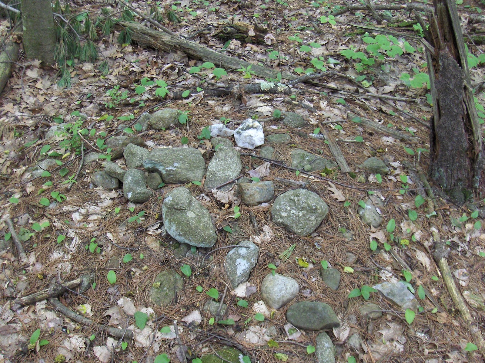
An inukshuk now sits where there was previously an ancient petroform depicting a snake. (Diane Maytwayashing )

   “Petroforms are arrangements of rocks that make up the outline of an animal or other distinctive shape when viewed from a distance. 
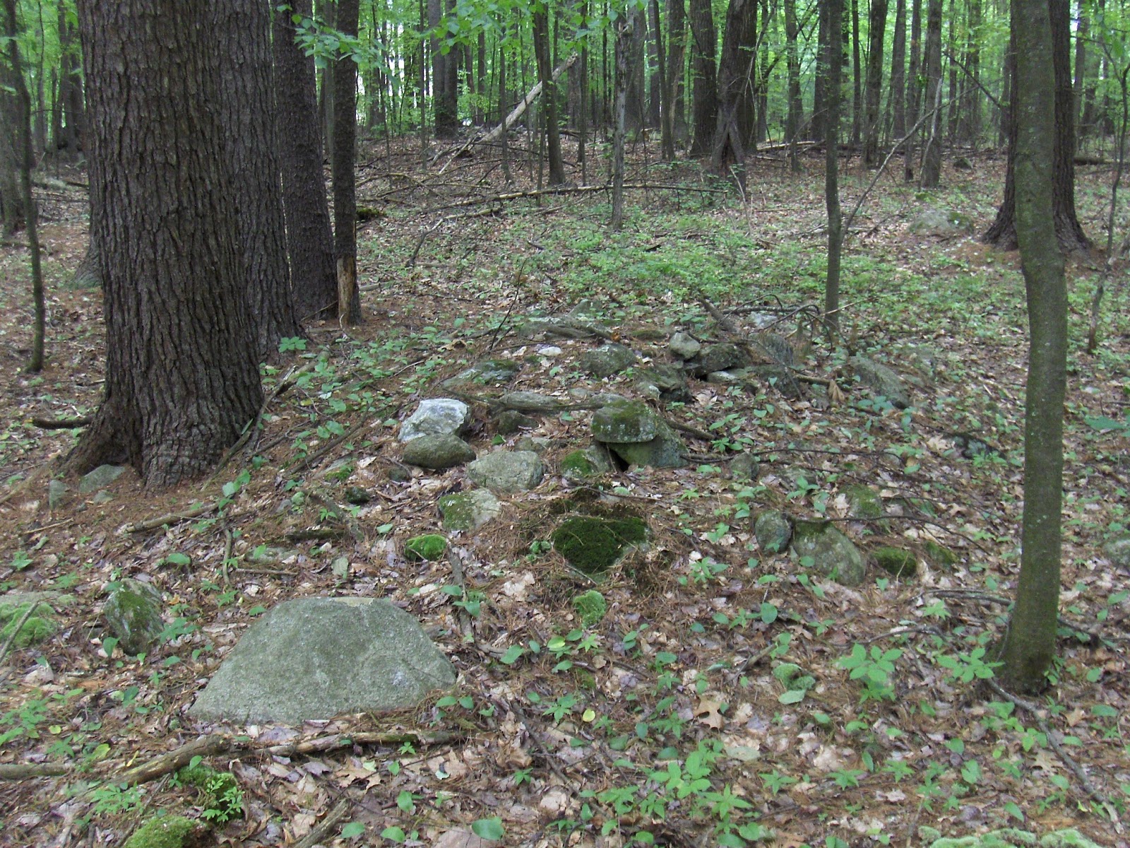
The Bannock Point site is a sacred place used from time to time by First Nations people for ceremonial purposes, according to Manitoba Parks and Protected Spaces.
    But when Maytwayashing and her group reached the petroforms, they discovered the stones of one — arranged in the shape of a snake — had been rearranged into an inukshuk.
   "I felt my heart fall to my stomach. It was really horrible," said Maytwayashing who guides visitors to Bannock Point and Tie Creek. "It kind of numbed me because it was like a violation was happening."
    Maytwayashing, an Anishinaabekwe woman and area guide and educator, said the snake represented a sacred feminine ancient story. She said the stones are considered as sacred as the Stonehenge in England or the Egyptian pyramids.
     "It was a place of gathering for thousands of years."
      Maytwayashing believes the destruction of the snake petroform and building of the inukshuk was a malicious act of vandalism...”
 Full Story:
http://www.cbc.ca/amp/1.4185107

An Update:
“An elder who's spent his life caring for a series of sacred stones that were recently disturbed in a Manitoba park says the site can be put back together and still has a future.
Ron Bell, who hails from the Sagkeeng First Nation, says the snake-shaped petroform at Bannock Point, which an Indigenous tour guide discovered disturbed this week, isn't ruined and doesn't need to be protected by security.

"This is nothing new."


Bell said he's been taking care of that petroform and about 200 others that are largely unknown in the Whiteshell Provincial Park for 63 years.
I have all this stuff recorded," said Bell, who started taking care of the site when he was seven-years-old...”
http://www.cbc.ca/beta/news/canada/manitoba/elder-manitoba-petraform-1.4187833

Wednesday, June 28, 2017

The Noble Point Effigy (Alberta, Canada)

(The Noble Point not-a-turtle Effigy?)
    “The Noble Point effigy (DjPa-1) is on the north edge of Chin Coulee, approximately 25 km south of Taber, Alberta. The effigy was first photographed sometime around 1967 and later recorded (1975) on an Archaeological Survey of Alberta site inventory form. However, its detailed documentation did not take place until 2009, when it was mapped by members of the Archaeological Society of Alberta Lethbridge Centre. It has not previously been included in rock feature comparative studies of Alberta and the Northern Plains. This article summarizes the efforts to relocate the effigy and the mapping process carried out by members of the Archaeological Society of Alberta. It also provides details on the construction of the effigy and explores its cultural classification and meaning...”


(Yes, he said it's not a turtle...)

The Noble Point Effigy (DjPa-1) (PDF Download Available). Available from: https://www.researchgate.net/publication/266797257_The_Noble_Point_Effigy_DjPa-1 [accessed Jun 28, 2017].

   "...But the most daunting question, because it encompasses aspects of all the others combined, is that of motive. Why draw large images with stone across the prairie landscape?
    Sundstrom’s report lists several possible interpretations for the sites including memorials to important people or events, identifiers of particular social groups, shrines related to war, hunting and planting, and astronomical observatories.
   “None of these are mutually exclusive and none have been decisively studied archaeologically,” her report says.
     Brace takes a practical point of view, saying that many of the animal effigies were environmental indicators, acting as landmarks or identifying the location of resources.
    For example, an effigy in Mankota depicts a salamander with a simple set of external gills, like one that lives in fresh water. The forms sits in an area with much alkaline water, but a line drawn from the tail through the head of the effigy pointed to one of the few fresh water springs, he said.
   Brace sees a similar use for a buffalo effigy. A line drawn from the tail through the head leads to a blind coulee where large game could be driven off the edge.
   The turtle effigies could mean that an important food source could be found in the area, he said...”

(Yes, he said, “The turtle effigies could mean that an important food source could be found in the area.”)
    Turtle found in the area of Alberta: 
Hmmm...


Tuesday, June 27, 2017

"Stylus Stone" from Hillman Mn

Reader Brian T writes:
... While investigating the rock cairn I found The "inscribed" rock on, I found a small fashioned tool  ( I call it a "Stylus Stone" ) .  Since then I have spent time researching trying to find a like item.  I was excited to find an almost exact copy 3700 miles away  in Yarmouth, submitted to the U.K Museum of Natural History for identification.       ( visit link below )  The first five pictures are the of the "Stylus Stone."


[Anyone want to guess what that is for? - PWAX]

Thursday, June 22, 2017

Above Above The Falls - Bolton

I wrote about "Above the Falls" before. The Ladies from Harvard also found it, and later Gail Coolidge found another site on the flat hilltop above. I think she called this place "Above Above the Falls". Gail and Sydney Blackwell took me there a couple weekends ago.


This site is one of the great ones in my opinion. It has a central boulder with rock pile, surrounded by large decrepit mounds - what I interpret as marker piles of an ancient type, and possibly a few burial mounds. There were also several small, newer-looking piles. Gail comments that it would be nice to see the place without trees. Boy would it! High up as it is, and flat, you would have been able to see Blue Hill, Wachusett, and Monadnock. As far as I am concerned, this is a "Stonehenge" that should be a highlight of any visit to Bolton Massachusetts. Today, with the trees it is a mysterious and moody spot, even perhaps a bit gloomy. Of course you have to ignore the lawnmower sounds in the background. Here is Sydney Blackwell and what I am calling the "central" boulder:
Here is a typical rectangle with hollows. Note the boulder in the background:
Then we examine a very messy linear feature ("wall") that leads from the suburban backyard,
though the site past the central boulder.
Passing things along the way. Here is a small pile with a white rock. The wall continues all the way across to the opposing suburban backyard. There is also a white rock in the wall.
The pile with white rock, looking in a different direction:
One of the larger mounds, that is more like a large marker pile than anything else:
Big, old, and triangular:
Not easy to photo, and you have to look close to see what I mean. I thought it looked triangular. Gail also thought it looked  "triangular". Another pile with a white rock:
Here is a different kind of rectangle with a hollow, made partially from soil:
Here is a nice combination:
This vertical sided pile looks to be from a completely different generation than the larger, more buried, ones.
The wall runs along past a number of things:
Again, note the boulder in the background. I did not notice it earlier but this is clearly a rectangular "U" quite similar to the one Sydney found, 3 pictures up.

(Another view:)
Here are 4-in-a-row:
It is why I am calling them "marker" piles. But they are more buried than any I have seen and at the larger end of the size range. More of the smaller newer-looking ones:
A last look at the central boulder:

I am impressed by:
 - the variety of different types of pile
 - the age of many of them, evidenced by the degree of degeneration and soil cover
 - the undisturbed nature of the layout
 - the complexity of the layout

This place begs to be surveyed and I bet there are alignments. The layout is similar to the original Above the Falls, with a central feature surrounded by marker piles. However, I never saw anything like burials at the original "Above the Falls" site and it is a lot "newer". I believe you can walk from one site to the other through the woods and it would be a spectacular park. Even more spectacular if you cleared the right trees.

Access is via a path on Warner Rd in Bolton. On the face of it, as we walked in, it was not at all the kind of place I was expecting rock piles. We were walking through completely flat, featureless, pine woods. There was one earthen bump to the left, but it was so out of place I assumed it was modern. Then we turned a corner, and I said to Gail "Are you going to pull a rabbit out of a hat?". She said "yes" and did.

Wednesday, June 21, 2017

Conservationists Want You to Stop Building Rock Piles

From the Smithsonian.com

I particularly like their quote from High Country News: 
indigenous peoples in the United States often used cairns to cover and bury their dead.
So, can we quote the Smithsonian now?

Tuesday, June 20, 2017

Stemmed Gems

I haven't found anything lately, but I was looking at my arrowhead collection and had forgotten finding the long tapered "Stark" point on the left. I always wanted one like that.

Fine "geology" - Propped Boulder Stagecoach Rd Lunenburg

What a spot.

Added: I just remembered Mavor and Dix reported a similar find, with Norman Muller sending photos and discussion here. Did I rediscover the same place? I cannot quite tell. Certainly my find makes me think the propped block was lifted from below. Yeah, the more I look, the more I think it is the same place. But it is weird; this was not an easy spot for me to get to - I think I was trespassing the whole time - lost also. All the less likely to get multiple visits from random rock structure enthusiasts.
Since Norman comments that the place is not easy to find, I would say: walk north on Stagecoach Rd (after sneaking around the residence and the "Private Road" signs) until you get to the highest point - where  the outcrops are visible next to the road. This propped rock will not be too hard to locate in that vicinity.
Update: Here is a report from Norman.

Thursday, June 15, 2017

Seen on Netflix

The rock pile jumps out of the picture for a moment.
And a few moments later:
What is up with that? Korean marker piles?

Beautiful stone tool

Not from the US but who can resist a beautiful stone tool?
https://phys.org/news/2017-06-neanderthal-homo-sapiens-transition.html

Tuesday, June 13, 2017

Traversing Grassy Pond Conservation Land - Acton, MA

I took a couple walks last month, both in Acton, going through woods and bits of people's backyards for an entire walk of 2-3 hours, without being seen. It is astounding that I was able to spend that long walking through undisturbed woods, in a neighboring town where I have been walking for years. It is not at all astounding to find several new rock pile sites. Of course that is to be expected in Acton.
I did not cross any roads. I parked at 'A' and a few yards into the woods there was a little rock stack, possibly modern, and a split filled rock.
Then northward, skirting houses and though a notch, then downhill to a little vernal pond somewhere around 'B'. The Acton trail map (critiqued for its weird compass orientation and lack of useful detail - see here) shows a vernal pond but, at this point, I am still off that map to the left (southeast!).
At the vernal pond:
You get the idea. Four or five piles hiding in the ferns.
Then I strayed as far to the left as I could (so actually west) down to the edge of the wet places. And around 'C' [I think] I was really in someone's back yards, pinched between the open space of the house and the swamp to my right, when I found two piles right at the edge of the water. One turned out to have a "tail" and a lump of white rock. The other was just a simple pile. Perhaps it once had vertical sides. This is one of the more interesting thing I have seen in a while - Acton or not.
First pile:
 closer:
Second pile:
Back of 1st pile:
 closer:
View back towards pile from the side:
Back of the second pile:
And that was the end of the excitement. From there ('C') I squeaked between houses to left and right, walked for a while without seeing anything notable and finally came to a small site, right on the yellow trail, about at 'D'. It was right at the start of the water, which flows south from there:
To the upper left in the picture!  
I exited the woods, just below the word "ROAD" on topo map above. 
Update:  Curt H. wanted to know more about the piles at 'D'. Here are a couple of pictures:
 
Here we are looking across the "yellow" trail.