Tuesday, September 25, 2018

Monday, September 24, 2018
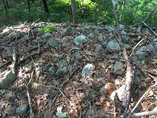
Korean Burial Mound
I was looking online for Korean burials. This reminds me a bit of some stone chambers.


Also, gotta admit, that shape reminds of something....
Saturday, September 22, 2018

Understanding Wendell MA

I just became aware that: "A group that’s protesting state plans to start logging at Wendell State Forest is preparing a petition calling for a halt in those plans as well as a weekly Saturday protest along Route 2 on Saturday (Sept. 22 2018)."
https://www.recorder.com/Group-protests-planned-Wendell-State-Forest-cutting-20322323
https://www.recorder.com/Group-protests-planned-Wendell-State-Forest-cutting-20322323
And then I click my way to this article that states: " A group of collaborating Native American tribes has offered to work with Massachusetts towns to identify landscapes of ceremonial or religious significance to their heritage, and Wendell is taking them up on that...The Wampanoag Tribe of Gay Head (Aquinnah) and the Pequot, Mohegan and Narragansett tribes are collaborating on this and have signed a memorandum of understanding with Wendell to share authority of sites of an indigenous nature."
https://www.recorder.com/Working-to-preserve-Native-American-sites-in-Wendell-13328361
https://static1.squarespace.com/static/5a230104914e6b1c9b2dfddb/t/5b7de89521c67c7f4f5d4292/1534978203963/Wendell+SF+cultural+resource+emergency+report+4-9-18sm.pdf
https://www.recorder.com/Working-to-preserve-Native-American-sites-in-Wendell-13328361
https://static1.squarespace.com/static/5a230104914e6b1c9b2dfddb/t/5b7de89521c67c7f4f5d4292/1534978203963/Wendell+SF+cultural+resource+emergency+report+4-9-18sm.pdf
A Google Image search brings up a whale of an example of Sacred Indigenous Ceremonial Stone Landscape feature:

I consider that it's "State Land," and the State is the Commonwealth of Massachusetts.
Not all that far from the Turners Falls Ceremonial Hill.
I think I'm beginning to understand...
I think I'm beginning to understand...


Monday, September 17, 2018
Hopkinton Development - poking around
Thanks to Tim MacSweeney for the previous post. Reading the newspaper article, let me quote:
UPDATE: Well I walked around and did not see anything....so false alarm?
Chairman Michael Roughan told the members last week they only have jurisdiction over structures under the town’s Demolition Delay Bylaw and there is not much they can do.Why are they quoting town demolition bylaws when NAGPRA is relevant? It is not surprising that the Historical Commission would be out of touch but what about the Native Americans?
“Unfortunately, stone structures and burial markers are not subject to a demolition permit,” he said.
In an interpretation of the town bylaw, Donna Brewer, who works for Town Counsel Ray Miyares, encouraged the board to speak with the Mass. Historical Commission
“Structures that do not require a building/demolition permit cannot be addressed through this bylaw chapter,” Brewer wrote.
UPDATE: Well I walked around and did not see anything....so false alarm?
Wednesday, September 12, 2018
Hopkinton Commission "Weighs In" Concerning Indigenous Stone Structures

HOPKINTON — Based on the opinion of two area tribal experts, several members of the Historical Commission want to further investigate the existence of indigenous ceremonial and cultural features between Chamberlain Street and Whalen Road...
Full Story:
Saturday, September 08, 2018
Behind the Wrentham Outlets
Moving on to the next spot along Rt 495, I am not sure what watershed this is in - south of a "Lake Pearl", almost the Ten Mile River. Today the eastern part of that woods shown here is all retail outlets.


 Quartz at the midpoint:
 From below


This is another pretty routine site discovery. Perhaps the best part of the story would be how I had decided to stay as close to water as possible (staying to the left in the picture) and gave up at the same moment that I was actually standing next to a rock pile:

I had gotten over to the edge of the wetland, as planned, and did not see much. These woods, especially along this wetland edge, had sketchy stone walls - almost broken into piles but barely meriting closer study. So when I got over here I am thinking "Well this is a disappointment....hmm that is almost a rock pile". Thinking this might be part of the loose wall, along this little ridge, I stepped a bit to the side (left in the above) and saw another -kinda- pile.

Just to be a little systematic, I stepped to the side again (left in picture), and prepared to call it quits, when something larger "loomed" in the distance:

Ooh baby! Let's have a look:


Beautiful. This mound and the smaller satellites were in a line along a ridge, actually an esker, next to the water. Here is a view, with a dirt bike trail in the foreground:

A bit to the right, was one other satellite, that I missed on the way in, and spotted on the way out.


That's it. My only comment is that this is like a marker pile site because the piles were, in fact, evenly spaced and in a line (the last pile was on a perpendicular line, if any) and the mound did not have a hollow. It reminded me of one other place off Red Coat Lane in Concord. As I look for a previous post on it, I found this site, also in Estabrook woods. But I cannot find the "Red Coat Lane" post - a mound like the one in today's report - also an oval with satellite piles next to the water. If you cannot find the report, enter the woods on the private trail on Red Coat Lane, and keep your eyes peeled as you walk in. The mound is on the left in the first 1/4 mile.
Thursday, September 06, 2018
Sacred Site to Solar Farm


Now and again, it is pondered here if some sites are still remembered, still visited by Indigenous People, who still use these sites for Ceremony, who mourn the loss of every piece of the Sacred Landscape...


(All Photos by Cora)
Monday, September 03, 2018
Cultural Landscapes: In the Eye of the Beholder (King)
Not the best produced video visually, and I'm only partway through watching it, but it is from the National Park Service:
"This webinar was produced as part of the ArcheoThursday Topics in Archeology Webinar Series hosted by the Archeology Program of the National Park Service, Washington D.C. office. The series was partly supported with help from Archaeology Southwest. For this webinar, Michael Roller invited archeologist, preservationist and author Tom King to present on research associated with the series theme of archeological landscapes.
Presentation Abstract: Archaeologists are often called upon to identify and evaluate all kinds of historic places, including cultural landscapes. In doing so, it’s important to remember one’s cultural anthropology. Cultural landscape identification and evaluation are essentially ethnographic operations. One needs to find the people – indigenous groups, local residents, visitors – who value the landscape and see if they’ll tell you what they value and why. Then think about how these values relate to the National Register criteria. It’s especially important to think about “integrity” with reference to the views of those who value a place. The fact that a place may have been modified in the past, that its soils may be disturbed, even that it may seem completely screwed up to you doesn’t necessarily mean that it’s lost integrity in the eyes of those who value it. In the end it’s their values, not yours, that matter most."
I'll also be exploring his blog: http://crmplus.blogspot.com/
- Thomas F. King holds a PhD in anthropology from the University of California Riverside (1976), and has worked since the 1960s in the evolving fields of research and management variously referred to as heritage, cultural resource management, and historic preservation. He is particularly known for his work with Section 106 of the U.S. National Historic Preservation Act, and with indigenous and other traditional cultural places.King is the author and editor of ten textbooks and tradebooks (See http://www.amazon.com/Thomas-
F.-King/e/B001IU2RWK/ref=sr_ tc_2_0?qid=1353864454&sr=1-2- ent) as well as scores of journal articles, popular articles, and internet offerings on heritage topics. His career includes the conduct of archaeological research in California and the Micronesian islands, management of academy-based and private cultural resource consulting organizations, helping establish government historic preservation systems in the freely associated states of Micronesia, oversight of U.S. government project review for the federal government’s Advisory Council on Historic Preservation, service as a litigant and expert witness in heritage-related lawsuits, and extensive work as a consultant and educator in heritage-related topics. He is the co-author of the U.S. National Park Service's government-wide guidance on "traditional cultural properties" (TCPs; see http://www.nps.gov/nr/ publications/bulletins/pdfs/ nrb38.pdf). He occasionally teaches short classes about historic preservation project review, traditional cultural places, and consultation with indigenous groups, and consults and writes as TFKing PhD LLC. Current major clients include several American Indian tribes and the U.S. Department of Veterans Affairs. Since 1989 King has also served as volunteer Senior Archaeologist on The International Group for Historic Aircraft Recovery’s Amelia Earhart Project, testing the hypothesis that the famous aviation pioneer landed and died on Nikumaroro Island in the Republic of Kiribati. His co-authored book, Amelia Earhart’s Shoes, was published by AltaMira Press in 2001, with an updated paperback edition in 2004 (See www.tighar.org/Projects/Earhart/BookReviews/ shoesreview.html), His historical novel Thirteen Bones, about the 1940 discovery of Earhart's remains, was published in 2009 (See http://www.amazon.com/ Thirteen-Bones-Tom-King- Thomas/dp/1608441857/ref=la_ B001IU2RWK_1_6?ie=UTF8&qid= 1353864465&sr=1-6).
Here too I'll be doing some reading: https://independent.academia.edu/ThomasKing3
Subscribe to:
Posts
(
Atom
)
