Wednesday, December 31, 2014

A Little LiDar

   This is new to me, the ArcGIS website. Trying it out for the first time, I was able to find two large stone mounds I had recently posted up here recently. 
The Second Large Stone Pile (and the ditch):
The rows of stones in the Preserve show very well in this Hillshade setting:

Tuesday, December 30, 2014

Roadside attraction - Weymouth

I rarely drive up Rt 3 from the cape but I did and noticed rock piles in the median - right in the town, a few yards south of the Middle Street overpass. Someone who lives near there should go check it out.
Cursor "cross" is the location. I just caught a glimpse, so they may not be real.

Monday, December 29, 2014

Noon Hill - final visit

I went back to explore the eastern part of this conservation area in Medfield. This included exploring near some of the sites I found previously, as well as a few new spots I had not visited before - like the main hill itself. A fair conclusion, for example, is that all the places near 'B' and 'C' should probably be considered a single site; with old, decrepit, small, hollowed piles at the water's edge, together with satellite piles. I also found one nice pile by itself at 'E' that was a bit different; and a line of piles cutting across the wetland at 'F' that were similar to a couple piles at 'G'. Sites at 'U' and 'V' were more one-of-a-kind. So let's look at some details.
Here we are at 'B2' with some piles overlooking the brook:
Then we walk east towards 'C', around the little knoll there, and encounter a few piles on boulders and these grumpy old things:
 Closeup of one, a forlorn remnant.
These decrepit hollow piles are the most characteristic features of this area. I found the above at 'C2' and another over at 'B4':
These are to be compared to the ones from the other day.
 An isolated pile at 'E', perhaps a different 'flavor' of remnant:

(Various views)

Then, as I was zig-zagging back to 'B3', I found an upper extension of the site at 'B'. 

Then south along the plateau with the brook to the west and a wetland to the east. I eventually hit some rock piles, near 'F', scattered across outcrops above the wetland, that seemed to line up roughly east-west. I do not know if they formed an alignment outcrop-to-outcrop, or if they were isolated each to its own outcrop. Anyway, they look like this:
and:

and:
 At the very highest point of all the water:
Very similar structures appear up on the shoulder of Noon Hill, along the same east-west axis,at 'G'.
Then...back down the hill...around the edges of a few more wetlands....and back to the car.

Excluding 'U' and 'V' which were a bit unique, and 'E' which was isolated, we have basically three sites: at 'A' are outcrop mounds, at 'B' are many low piles with hollows, at 'F' some sort of alignment and sky watching -over the water. The majority of piles are at the same topographic height above the surrounding rivers.

Saturday, December 27, 2014

Noon Hill - sites in the interior

I only scratched the surface when I was there before, and last weekend I did a more comprehensive tour of the western half of this conservation land. Followed the ridges west of Holt Pond towards the south, and swung east and back north along the central ridge there, and started seeing rock piles a little south of 'A' on the map. 
After going a ways without seeing anything, you hardly believe it when rock piles do show up. 
I was walking along the eastern edge of this ridge, trying to keep an eye on the valley to that side.
I saw a couple of things that could be rock piles on the more level height to my left. Went to take a look:

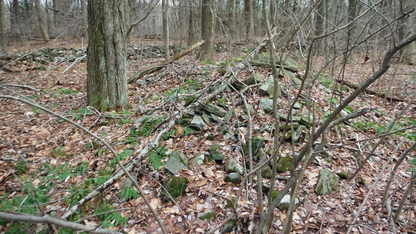
Poking around up there (still near 'A' on the map), I saw this pile built against a boulder:
This is essentially the same structure as I showed a couple days ago from next to Holt Pond (at 'D' on the map [see also comments in the past about how rock pile styles change to the north of Horse Hill]) and you know I consider this "gravelike". So now I start sniffing around for rock piles with hollows and, easily enough, found the messy structures I hoped to see - exactly at the height of land, looking north towards the river valleys.
Several shots:
We could regard this as a complete mess, or as something that has lost a lot of its shape. Up here on this rocky hilltop, there was no farming going on nearby. But look where the big rocks are, and where the small ones are. We see more of these "eyebrow" piles, delicately building out the natural outcrops:
And we look at the outcrops from below, so see how the piles spill over them:

Here we are looking east, the yellow spot trail crosses in the foreground - mounds built into every high point.

From there I went down into the valley, where the yellow spot trail crosses the brook near 'B' and found a different kind of site, with a "donation" style pile, and other low decrepit things along that valley of the brook.

One of those places where there are many piles lost underfoot. Here we are looking west towards 'B':

I went up this little valley, over a ridge and down to another wetland at 'C'. This is where we hit the kind of rock piles I like as much as any - the oldest form of rectangle with hollow: small enough for one or two occupants, so old as to be a simple bump in the landscape. They do not photograph well:
A sketch:
There were perhaps 6 of these around 'C' on a gradual slope over the water. 
Another:
I am reasonably confident the people who traveled along the main rivers (we are about 1/2 mile from the Charles River) came up the brooks and lay their dead to rest in these quiet coves where the brooks begin. But they never got too far from the river. Some sought out the heights (at 'A') and others sought out the wetlands.
Look carefully:
Do you see two "arms" of structure with a hollow in between, facing into the wetland? That is how they sit today, almost gone from view. 
A few outlying satellites:
Walking out of the conservation land, along the wet areas forming into the brook, there were a few other loose shapeless scatters:

I walked out via the orange spot trail, down the eastern side of Holt Pond. There were a few more piles there at 'D':

A full walk.

Monday, December 22, 2014

Right under his nose

Here is a little story. I was looking at this short stretch of wall:
and an adjacent rock pile:
 (view back towards wall; according to my photos, there was another small pile at the lower end of the wall)
A small yellow lab ran up barking but wanting to be friends and I stopped to say hello to him and his owner. Since we had stopped right at this rock pile I thought I would poll the owner and asked politely: 
 - What do you think of that thing you are standing on?
- (him) What? I don't understand what you mean.
- I mean the thing you are standing on. 
- (him) Oh, this rock? 
He had a foot on one rock. I gestured at the whole pile and said something like (apologizing for intruding):
- No, I mean the whole thing
- (him) I guess it is a collection of rocks.
- Do you think it is man made? I ask
- (him) It's hard to say.
I pause and then say:
- It is not hard at all. 
Then we discussed the nearby wall, and agreed the wall was for some other purpose than the rock pile.

Sunday, December 21, 2014

Holt Pond Medfield

For example:
Norman

Philip Smith's Article on Georgia Stone Walls

For those of you interested in reading and downloading Philip Smith's important and groundbreaking article on ancient stone walls in Georgia, titled "Aboriginal Stone Constructions in the Southern Piedmont,," which is no longer accessible at the University of Georgia website, here is a link to it:

http://www.larryharrop.com/Lab%20Series%2004%282%29.pdf.

Second Large Stone Pile

     I took a look at this Big Heap-of-Boulders - because I could see it in aerial images. I wandered into more or less the opposite corner of the same preserve and came across a second large heap or pile of stones, cobbles rather than boulders this time, not visible from any aerial image I can find.
     I was walking along a row of stones that extends southward from a 1750 Cemetery:
Above: Not to scale mound drawn into a not to scale trail map.
Above: looking NNE
The mound is almost like two mounds joined together - or maybe a shape like the reverse of the numeral 6 or 9, possibly linked by stones in a row to the substantial southward row, but also to what appears to be a ditch extending NNW, stones perhaps piled on the eastern edge of it - it was indistinct beneath all the duff covering it, although I thought I glimpsed a little serpentine sort of structure to it.
There were also spots where it looked like stones were removed... 

Above: the larger portion.
Below the second, smaller portion: 
Hint of Effigy? 

Above: a rhomboidal stone obscured by duff and debris.
Below: Looking toward ditch. 


Row of stones leading to the substantial row: