This is about rock piles and stone mound sites in New England. A balance is needed between keeping them secret and making them public. Also arrowheads, stone tools and other surface archaeology.
I was invited to give a talk at the Acton, MA Library. The title is
"The History of the Ceremonial Stone Landscape Movement - a Local Perspective".
The talk is at 7:30 PM on Thursday November 3. I am told this will also be available on ZOOM as part of the "Friends of Pine Hawk" Lecture Series. Note: to join via ZOOM, you have to register. See:
I intend to tell the story from my point of view, and spend about half the time speaking about ethical issues that surround the topic - for instance: who has the moral authority and who has the intellectual authority to determine how sites will are treated by society.
We went to the museum as a follow up to visiting some of the "cairns". I wanted to see info about the geology of the area, maybe an arrowhead or two, and perhaps more info about the rock piles. I was well served.
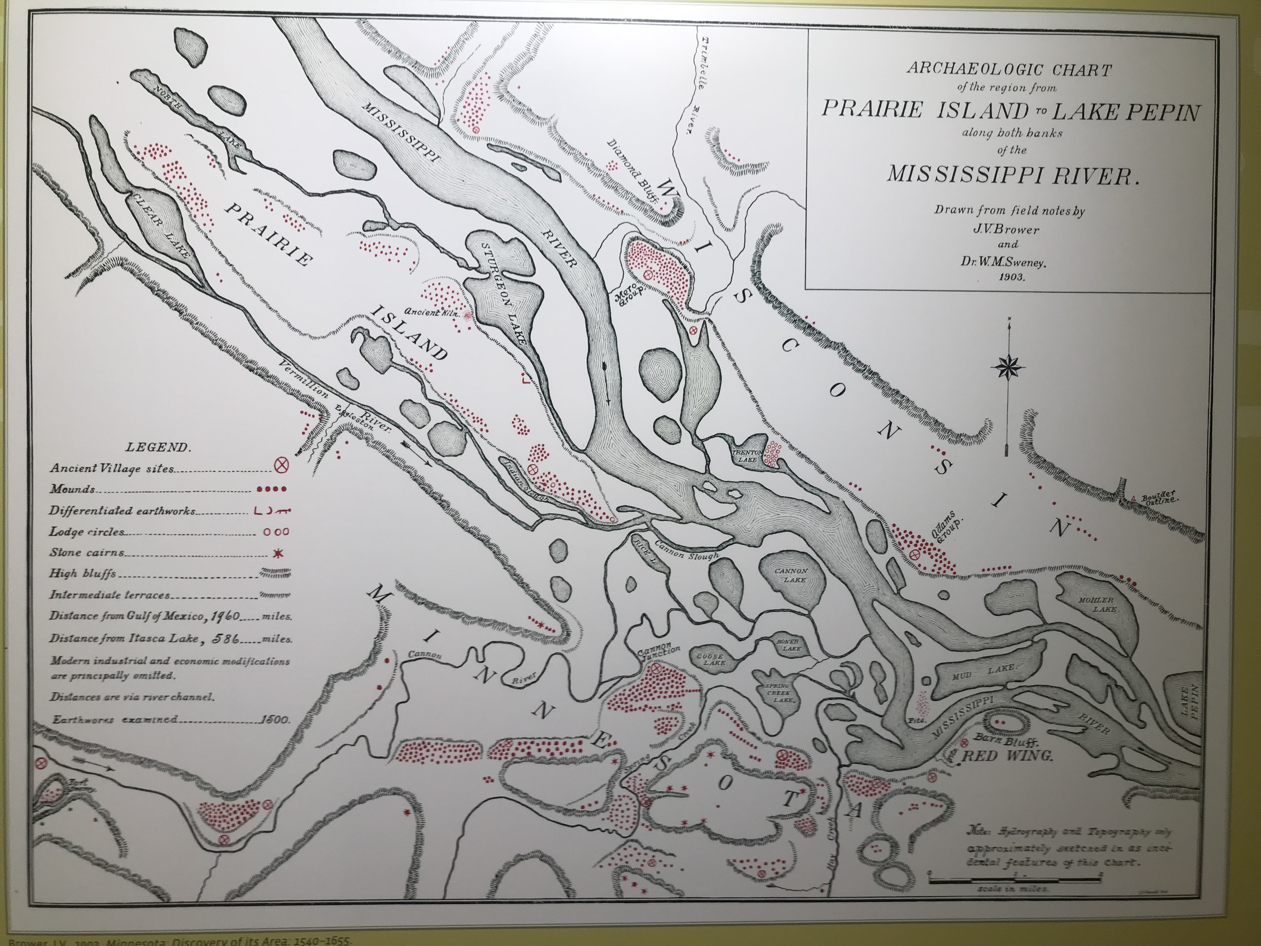
Apparently there were more mounds in Red Wing than anywhere else in the US. This map, although wrong, has some important details:
Later on, I looked at this pretty carefully. The little "stars" represent "cairns" and I count 12 of them in the lower portion of the diagram.
My guess is that after visiting this museum, a visitor will be more confused about the Indians than before they visited. To my mind, the way the rock piles are all on one (western) side of the river; the way they are all up on bluffs but few of the earthen mounds are up there; the way some of them are clearly much older than others, says to me that this is not all the same Indians - the past is not all one, white-washed, uniformity. What he have here, along the Mississipi, is: earlier people, replaced by mound builders, replaced by the Dakota Sioux. They use the label Silvernale and manage to mix together [or at least fail to create meaningful boundaries between] just about everybody who ever happened to paddle by on the river. In more recent times this was a place somewhat between the Athabascan Sioux, the Algonquian Chippewa, and the people from down south (not sure "Natchez" is the right term). Today, I wonder if the Sioux are happy to be confused with the people who made the many mounds, shown dotting the map.
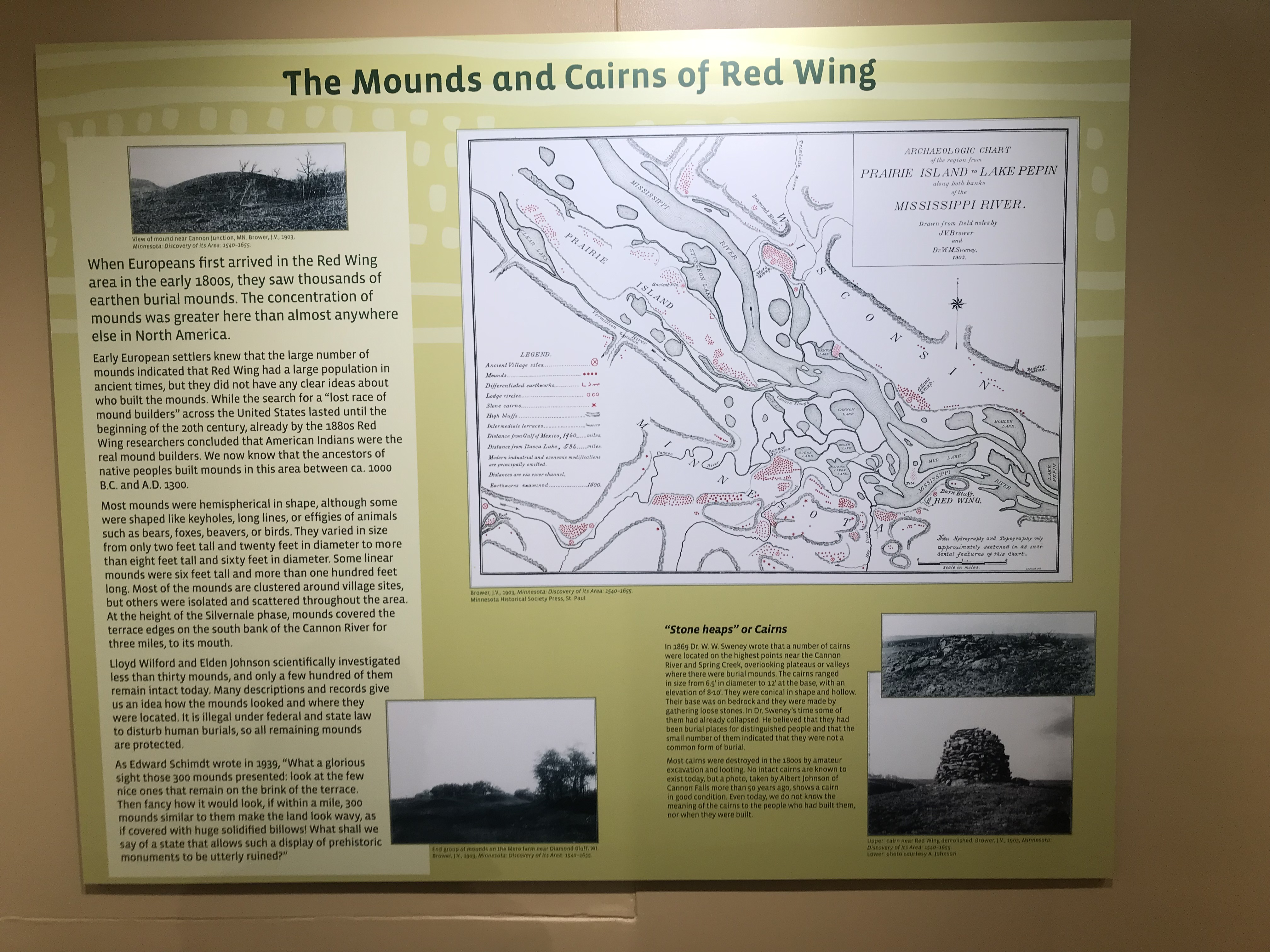
Another thing I would quibble with is the idea that these "cairns" are all the same. I found three distinct types of structures on that one hill (not counting the 'alignment'). None of them could have ever looked like that fat 'biscuit' that we see in the old black and white photo. Behold the entire poster:
Two details:
Wow, those earthen mounds must have really been something. Quoting the poster, quoting Edward Schmidt in 1939:
What shall we say of a state that allows such a display of prehistoric monuments to be utterly destroyed?
It might as well be Massachusetts, as far as that goes.
As for arrowheads, the display furthers the confusion about the variety of people from the past, with a photo of an old gentleman proudly holding his best paleo point. But they displayed the results of more recent digs.
What I am seeing is mostly side-notched points from the same style as mound builders and Mayans. Presumably these are the "Middle Mississippian" arrowheads. Ignoring the curious expertise that allows them to date rocks while ignoring the archaeological context they are found in, I can still say - why did they mung it all together? Adding, that the lighting was such that, if you bent over to look closely, you blocked the light and could not see anything.
In spite of my bitching, it was a gorgeous little exhibit, within a beautifully appointed County Museum. They had dollars to spare.
When I look carefully at the red dots and stars on the map, although it is hard locating the landform of the "Spring Creek Prairie" conservation land, I don't see any sign of 5 (or six) piles close to each other, nor any sign of the lone mound at the end of the ridge. In fact it is somewhat impossible to match the bluffs shown on the survey map with today's topographical map. But it sure does leave me wanting to go back and try to get some things right.
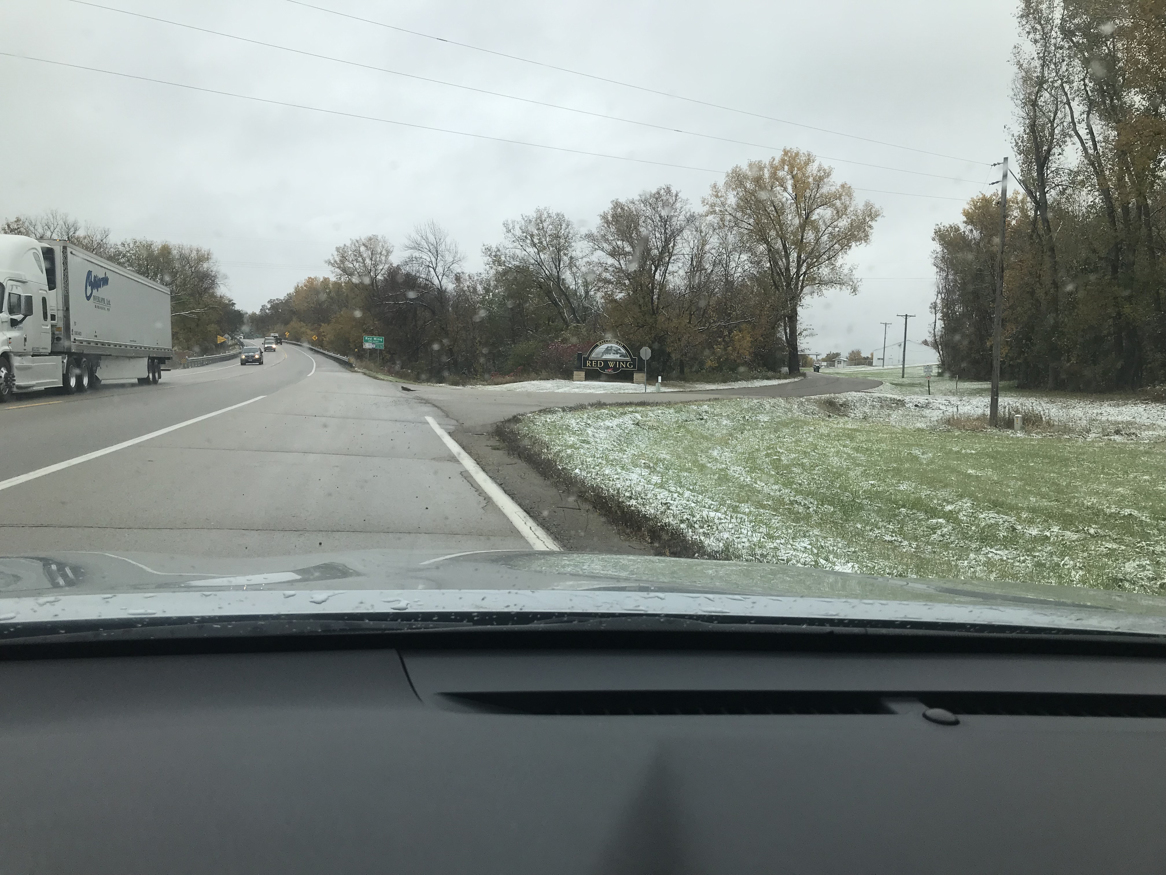
We woke up in Lake City, south of Red Wing, to a day with the first snowfall. Trying to decide whether to go walking outside, we had nothing to do except drive back to the Twin Cities for dinner. So we decided to forgo the hunt for Tundra swans that were said to be migrating through at the time.
What the heck - we decided to hike in spite of it raining and spitting snow. As it turns out my wife and I have good luck when out in the rain by ourselves.
There is some tourist info, and a couple of YouTubes, but the best info available for locating the famous "Red Wing Cairns" was something I linked to long ago, that came from Norman Muller:
With this in hand, and a local map showing a bona fide conservation land, we went to "Spring Creek Prairie". There was a road that took us up to the top of the bluffs [that is the geology of Red Wing, where the land along the Mississippi is several hundred feet lower than the surrounding country].
After a few steps down the main trail, I headed left into the woods to see what I was dealing with. I thought I would come to the edge of the bluff but the land slopes more gradually on the western side of these bluffs.
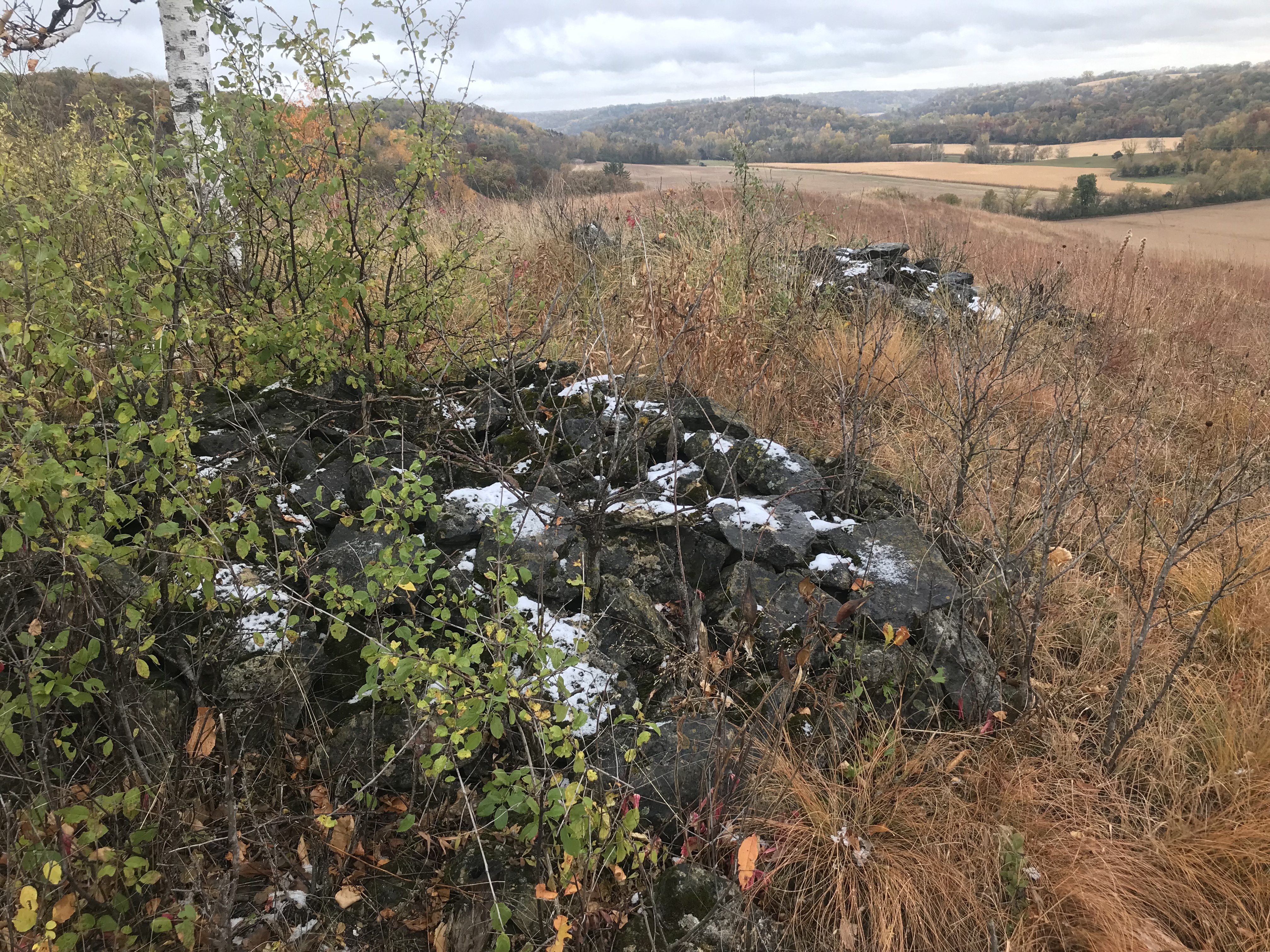
So I came to the first rock I saw on the surface since arriving in Minnesota. What do you know, it was part of an "alignment" - a curved course of evenly spaced rocks. Just like "marker piles", the basic layout is familiar to me. There was an old trail back in there which we followed until I got worried we were getting too far from the main trail. We got back to it and followed it down and over to a high hill. You kind-of knew you were getting to the place.
A beautiful side valley, not visible from the Mississippi. And there are the rock piles in the bushes:
I don't know if anyone cares about my observations but there seems to be quite a lot of misinformation out there - starting with the original surveys from 1903. One bit of misinformation is that these cairns are completely vandalized. I am not so sure because there is no sign of other rocks lying around the damaged cairns. What you'll see in these videos is five tightly grouped "cairns" around a central hole - that is dug into the bedrock - and a possible sixth pile that is completely gone. I always kick myself later for not paying attention to the exact details that I went there hoping to see. Ah well! With videos, at least we can take a better look around:
And
I will say that these "cairns" were faintly donut-like. Yet I do not want to believe these are burials. There is another possibility - that building a small rock piles, you do not need to fill the center as you build up a 'circle" of walls.
There was a distinctly astronomical feel to the place. I have never seen such closely spaced piles. AND I found another of those curved - "marker pile" - alignments, hiding in the grass there. Here is five "in a row", quite similar to what I found at the start of the walk:
According to (me), this only works to mark the passage of time if there is a shadow source that casts its shadow, more or less perpendicular to the 'alignment'. Only thing up there that would make such a shadow is the "cairns" at the top of the hill. So burials - maybe - or part of an astronomical arrangement.
In fact there were lots of other little rock piles around that have not been noted:
Let me call your attention to the sharp little "bump" at the end of the ridge on the left. On closer inspection, it was the largest "cairn" around. But old and covered with grass and flowers:
Sadly, I could not find this on the 1903 survey or on the more recent poster from Norman.
It is a totally beautiful spot. Rock piles at the edge of the prairie. The grass/flower combo is natural prairie. But all other places have been erased. This is just a little patch of what used to be everywhere.
Looking back, this is the hilltop with the "cairns":
Here, we have scrub oak in the foreground, other oaks in the background, and a tiny peek at the distant highpoint with the small birch tree.
What a place. A couple other pics:
Look at the "line" of ridge and pile, aiming away towards the southwest.
It is so tempting to go back and look for the other cairn sites. According to the poster, there are seven other places with rock piles. According to the 1903 survey (coming up next when we visit the local county museum) there are 10 cairns located around Red Wing.
My sense is that no-one has looked that closely for things. Except where it has been plowed [apparently nearly everywhere] there are very likely to be small piles on all the bluffs around here. The 1903 survey was busy looking for village sites and earthen mounds. They did a mediocre job with the "cairns". [To be continued.]
There is more to come, but this is my best picture. The mound at the end of the ridge my wife is standing on, is another larger, undisturbed rock pile - with grass on it. I wonder if other people noticed it and, frankly I cannot reconcile this with a map of mounds I'll show later:
The sentence in bold, italicized letters - also in parentheses - is my own editorial addition. -Tim
“To know New
England well, one must know its stonewalls,”
claims Robert M. Thorson, author of the definitive history Stone by Stone
(2002).”
“According to
Thorson, New England’s soil wasn’t rocky enough to support the building of
stone walls before the arrival of colonists, who clear-cut the land.That exposure, coinciding with a period of
colder, drier winters in the late 18th and early 19th centuries, caused the
ground to freeze to a greater depth. Conditions “worked together to accelerate
the heaving of stones from the soil,” Thorson writes. Combine those
circumstances with a dearth of wood for fencing—since forests had been cleared
for farms and fuel—and the stone wall was born…”
(Thorson
believes, without evidence other than folklore about Yankee Exceptionalism,
that:)
"Most of our stone walls were built between the
American Revolution and the advent of the railroad, when settlers moved from
the coast into the rocky uplands and property ideals shifted from the communal
to the private, Thorson explains. However, some stone walls in southern Connecticut
date to the colonial era. Early on, Thorson says, farmers simply rolled stones
into piles in the middle of their fields…The strongest kind,
“disposal walls,” were constructed of two parallel walls with stone fill
between them. Then there were “walking walls” with “broad capstones… laid flat,
like a sidewalk,” Thorson writes."
“English-style” is the way one Woodbridge resident describes
that same type of wall. I meet him one icy afternoon while I’m taking
photographs and he’s walking with his dog. He rebuilt his own wall, he tells
me, from the tumbledown remnants lining his small stretch of Sperry Road. He
points east toward the Glen Lake reservoir, just over the rise. When the water
is low, he says, old stone walls can be seen in the flooded valley.
“Left untended, every wall will come apart,” Thorson tells
us. Some are even plundered, with or without landowners’ permission, to be sold
at rates around $200 per ton, according to an Internet search. While
Massachusetts, New Hampshire and Rhode Island have protected their stone walls
with legislation, Connecticut hasn’t, though they “may be protected under
historic preservation laws,” the General Assembly’s website says.
Facts may help us get to know the old walls, as Thorson
insists we should. But perhaps the best way is to bundle up and walk into the
woods. Rounded and flat, bramble-covered and exposed, green with moss or white
with snow, you can find them there, no longer keeping cows from corn or
neighbors from one another. It seems we may love them more than those who built
them ever did, which makes you wonder: What casual constructions of ours will
our descendants value?
Written by Kathy Leonard Czepiel. Photographed by Dan
Mims. Image features a fallen tree meeting a stone wall along Route 69. This
story was originally published on March 9, 2018.
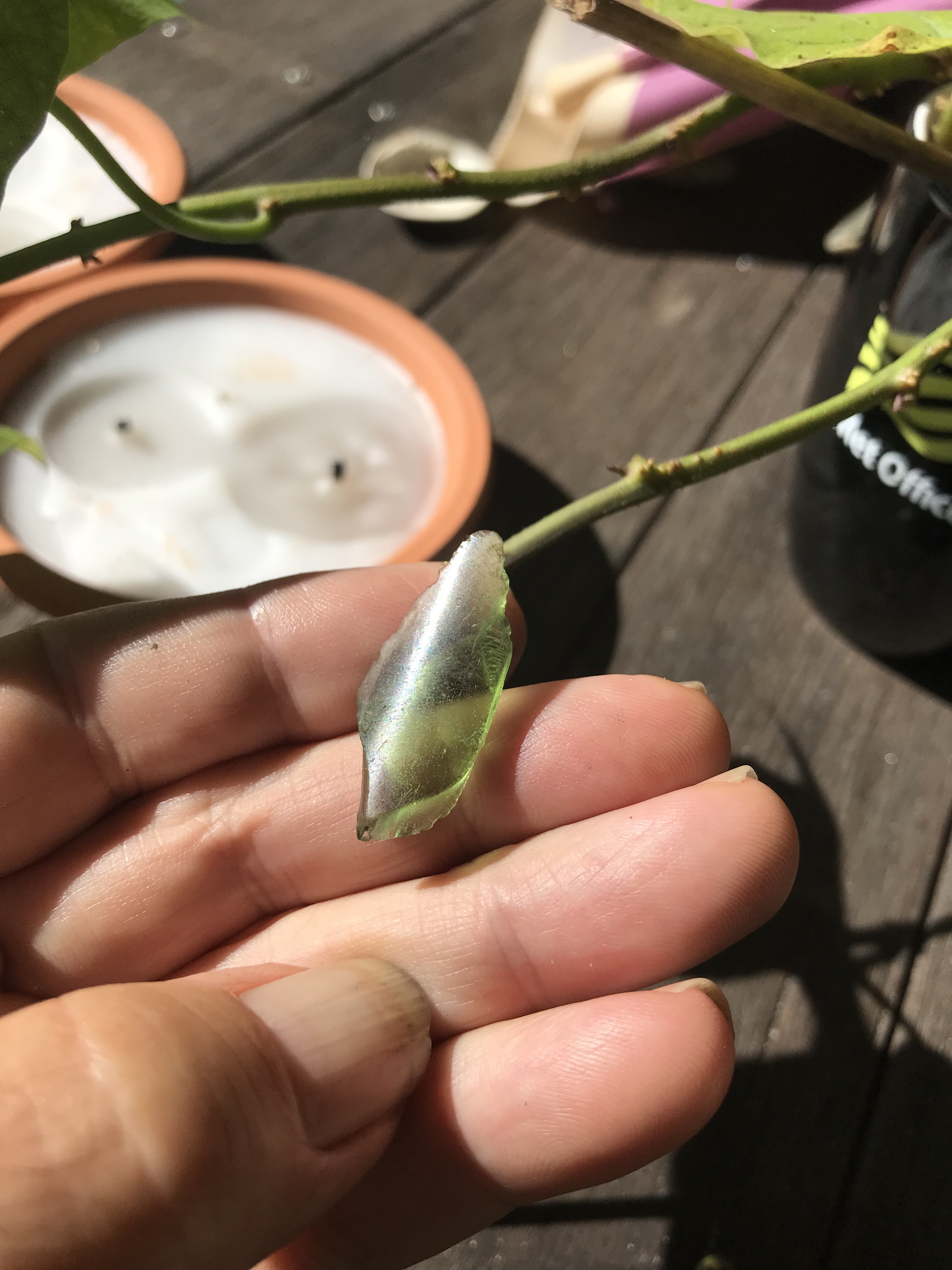
I was looking very carefully at the gravel on Ram Island today. This just looks man made to me:
I am particularly suspicious of the serrations on each edge of the point, but not present on the other edges.
It is a pretty little thing. I think I'll keep it with my growing collection of broken arrowheads from Ram and Devil's Foot islands. Someday, oh yes! someday, I will find a complete, un-broken and unimpeachable point. In the meantime, it is always fun looking at the gravel on the corner of Ram that is closest to the gut. I have been finding broken bases of Merrimack points there and larger, axe-like, items on the opposite side of the island.
(From Alan P) I wrote to you a while back about the effort to protect the Archaic site in Northampton where the city and state intended to construct a roundabout and I want to thank you for taking up the issue with your readers. The project's now on hold as you know, hopefully permanently but we will see. Anyway I thought of you and your blog again recently when I noticed something interesting in this video (though perhaps you've already seen it?):
It shows horseshoe shaped stone constructions positively known to have been used as hunting blinds by caribou hunters in the Yukon up until recent times. To my eye they resemble similar structures found in the hills here in New England. Given that this land was also caribou country thousands of years ago, with the same landscape and ice features present, it may point to the function of at least some of those found here imo. They're briefly discussed starting about the 11 minute mark but I think you'll find the whole video fascinating, especially while keeping possible clues about post-glacial lifeways in our area in mind. Take care,