Friday, November 10, 2006

Panther Orchard Farm - Part Three

In Part Four we'll look at a collection of many of the rock piles found on Panther Orchard Farm. But before we get to those, let's first have a look at other remarkable features from this property. First, a possible niche:
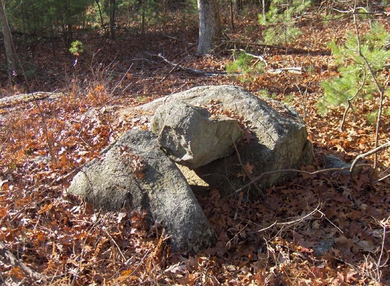
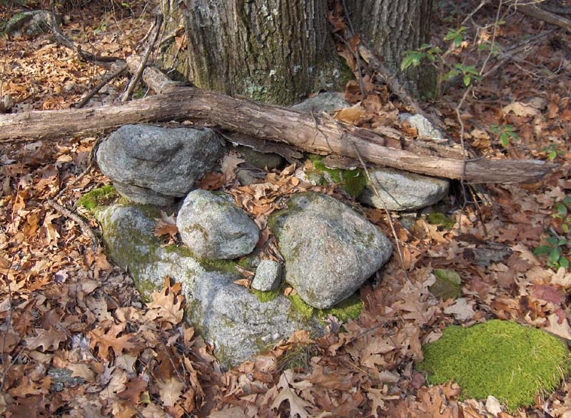
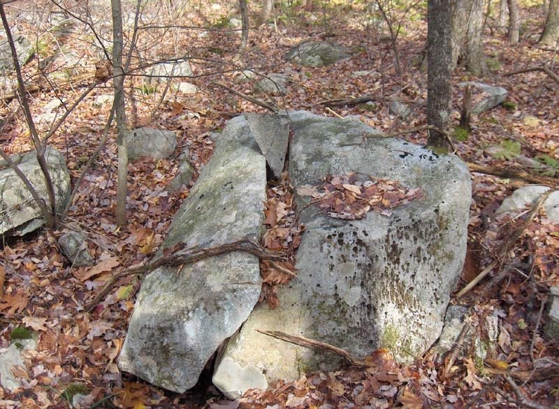
We also spotted a familiar feature -- the ol' split-wedged boulder:
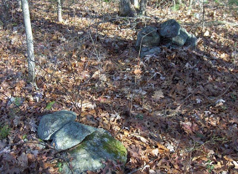
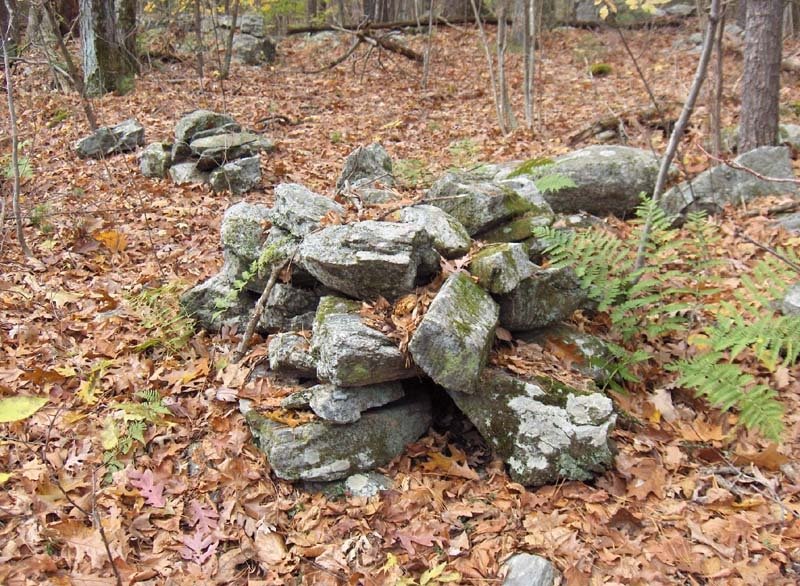
There was also a most amazing pile of rocks of a very special sort -- I've never seen anything like this. It's difficult to see from the photo -- I wish it had come out better -- but at least 90-percent of the rocks in the following large, scattered pile are quartz. An enormous dead oak tree once grew right in the middle of the quartz pile. It was an incredible thing to find. The pile was wide and appeared to be deep. I've never seen so much quartz in one place before:
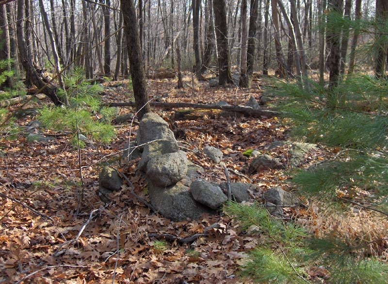
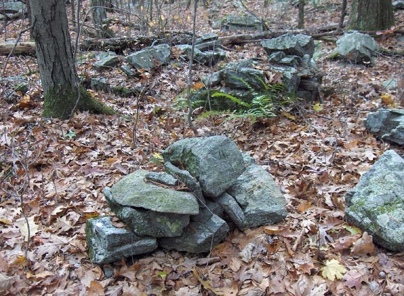
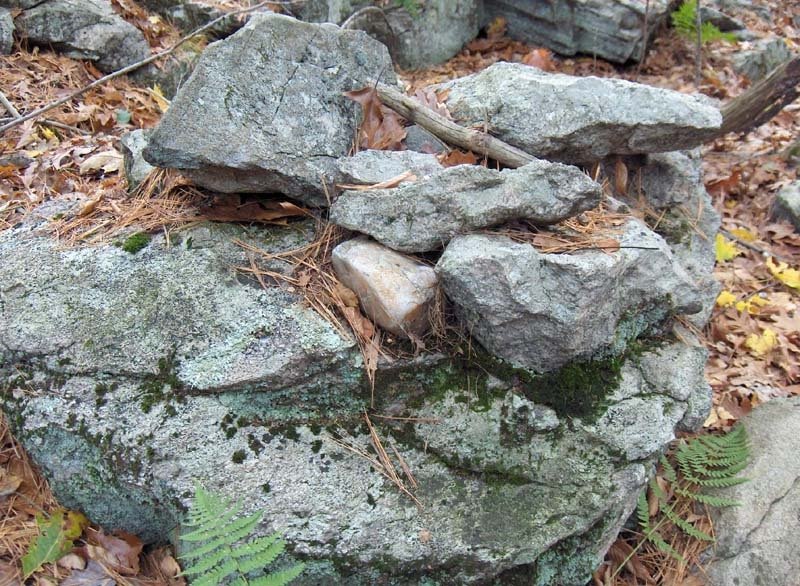
We also spotted this triangle symbol like those found on the Miner Farm. This one has had a small tree apparently lift it from its supporting rock and boulder:
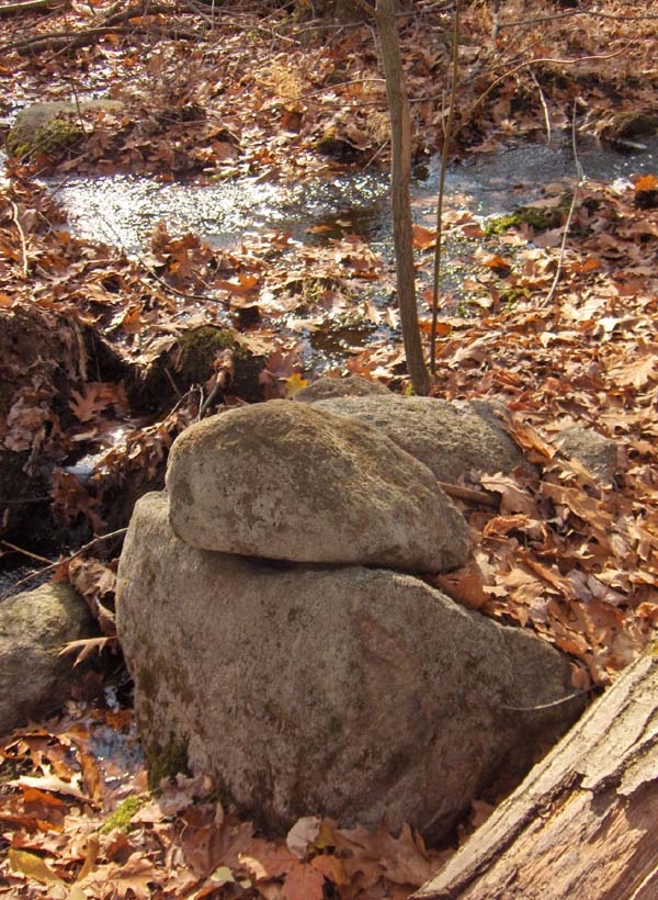
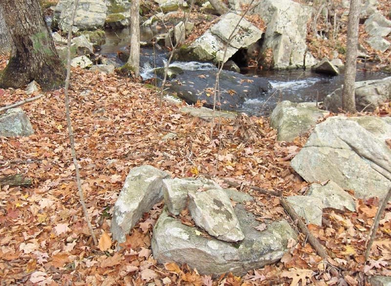
Nearby was the following boulder with prominent quartz veins and loose pieces of quartz on it, most of them encased in moss. Were these left here by humans? I think they were. Perhaps some of the quartz projectile points plowed up on the Miner Farm throughout the years were quarried right here?Keep an eye out for our final look at the features -- specifically the rest of the rock piles -- from Panther Orchard Farm in Part Four!

Thursday, November 09, 2006

Faintest of traces

...still out walking with FFC in northern Westford. There are the faintest of traces. It is getting much easier to notice these things; but it is no easier to interepret them when they occur in isolation and with little context. This was a walk across a gently sloping piece of oak/pine regrowth forest. A Westford Blogger drew my attention to this patch of woods and, even as they said, it is a only a couple of steps ahead of the developers. The area was logged and flagged.

A boulder with a ring of stones coming out from it. Possibly one kind of enclosure or "seat":

Some kind of gate?
A manitou stone making up part of a small feature:
A precarious wedged rock:
These all were not part of a single cluster/site but were scattered along the slope at low density.

Showing off some favorite piles

Walking with FFC in northern Westford. Here are some favorite piles I wanted to show him. Here is one of my all-time favorites (I think I posted another of picture of this some time in the past):
Here is a detail, showing a white "window".
Here are some others from the same northwestern hill shoulder:
This is part of a what I call a "marker pile site" because some of the piles are evenly spaced and in lines. On the other hand these large boulder piles are probably not in line and, although it is possible, I do not think anyone moved the boulders in order for the piles to be "just so".

Did I tell you about Leominster State Forest?

I mentioned it here and here. It is a dark and gloomy place. I think I mentioned the difficulty (and sometimes near impossibility) of forging a path through the moutain laurel. Anyway, I told you so: [Click here] Reading the news story I have a couple of thoughts: First is "hey that's Parmenter Rd where I walked on Sunday!". Next is: "what the heck was a hunter with a .22 doing in there?" There is no hunting allowed and it is a forest road closed to the public with a locked gate. So how did his vehicle get to that spot? When I was there last weekend some pickup truck driving group picked the lock, went in a ways, and were cutting themselves a winter's worth of firewood. Is that all standard for a State Forest?


Quoting from the newspaper:
"Fire officials said a major hindrance is the thick growth of mountain laurel bushes, a protected species that is an attraction at the state forest. They said it is easy to become disoriented in the shrubbery, especially in last night’s steady rain and lack of moonlight. "

Based on where his car was parked (at the foot of a forest road that leads north) and based on my personal experience that you can only really travel on the roads and open trails, and based on the report that the man was "near a river", it seems pretty clear where the man ought to be: right down hill (east) from the little brookside site I reported the other day.

OK, the man found his way out. [Click here]

Tuesday, November 07, 2006

Fenton Rd, Leominster State Forest (continued)

... So I went back to the trail and walked back sotuhward towards the end of Fenton Road and when I got to the stream crossing I got off trail to explore down along the brook. Pretty soon there was a first rock pile beside the stream with the sense that there were others beyond, and there they were. First one or two, then some small clusters. But not too many solitary rock-on-rocks. With all the sound of running water going by, that puts this site sort of into the category of "Above the Falls" in Bolton. I made videos:


And here is one nice cluster off to the side: Here is another that caught my eye, and another by the brook that I thought was nice:
Still more.As I look at these pictures I am struck by the similarity in structure of 1st, 3rd, and 4th. They all have a curved trailing away structure made of three or four stones. Also my forced comparison with "Above the Falls" causes me to look more carefully at the relation between the two piles in that last photo. Is that a "gap" between them?

Fenton Road, Leominster State Forest

Although much of Leominster State Forest is impenetrable because of the mountain laurel, I have often wished I could get to some of the more obscure parts. I noticed a thin trace of forest road leading north from Parmenter to the right of Rocky Pond and, because I had once noticed those little brooks descending the hill north of there and also because that little forest road leads over to at least one of the brooks, I thought it would be worth the effort to get out there, even though it amounted to a mile or so of slogging on those Leominster State Forest roads. So off I went on Sunday. That little forest road has the name "Fenton Road" and it runs just as indicated before stopping. After that you can continue on State Forest Paths and I did for less than a quarter of a mile before stopping and thinking I had gone far enough. By then the woods had opened up a bit on the right and it was possible to explore east and downhill from the path. There was a very indeterminate rock pile site there - close by an old foundation and with very little sense of sacredness or ceremony. Could they be something other than ceremonial? I was not able to decide but was not so thrilled with the discovery. Then I turned back and got off the path to explore down stream at the point that Fenton Rd crosses the brook (above the "R" at the end of "LEOMINSTER"). Sure enough there was a site there as I had hoped. Ironically I proposed an experiment long ago involving predicting where the rock piles were and then going to check. Well one of my predicted locations was exactly that brook and, I think, I just succeeded with the original experiment. Yes there were rock piles there.

I walked all the way up Fenton till it turned to path, followed that along for several hundred yards, and then saw a kind of rough wall made of earth and rock heading downhill to the east. The woods were open enough in that direction that I got off the path to go take a look and found rock piles (approximately in the upper blue outline). They are really non-descript. No quartz, no sense of alignment, no sense of shape.
It is nice to see them in the laurels. Perhaps they are quite distinct in a shape I do not recognize.

These piles were near this structure, a historic age foundation for I don't know what.
I poked around a bit back to the south along the same slope of hill and came on another small cluster.Still not very satisfied I must believe these are Indian piles perhaps because they are small and placed on boulders. So I went back to the trail and walked back sotuhward towards the end of Fenton Road....[continued in subsequent post].

The Pachaug Hoax

The above image was sent to me several months ago by NEARA's Rhode Island State Coordinator Jim Egan. The photo was taken in the Pachaug State Forest in Voluntown, CT -- a well-known place to local folks with an interest in ancient stonework. Pachaug makes up a chain of contiguous conservation lands, as well as a relatively unbroken series of cairn sites reaching into the Arcadia and Rockville Management Areas -- two Rhode Island sites discussed extensively on this blog.

Back in 1998, a hunter stumbled upon a rock shelter site in the Pachaug State Forest. It was excavated by a team headed up by CT State Archaeologist Nicholas Bellantoni. Not much more than a few projectile points and potsherds were found. Bellantoni moved on and left any further excavations to a small team of volunteers who were trained by him.

The following Summer, the team of volunteers made remarkable discoveries. They uncovered copper beads and pieces of a clay pipe. Bellantoni ordered tests of the artifacts. A UCONN physics professor named Cynthia Peterson conducted light and heat radiation tests, determining the artifacts to be 1,000 years old.

In August of 2000, Bellantoni along with the Pequot Museum Research Director Kevin McBride returned to the site for further excavations. About 40 feet from their original excavation site they uncovered a series of amazing artifacts. But the two became increasingly suspicious. There were some problems.

Loose dirt was detected where the soil should have been compact. A tree root was unnaturally severed. A fully intact oak leaf was found at the bottom of a test pit. A snake intricately carved from copper had not properly corroded. A stone pipe appeared to have a machine-made borehole exactly 3/16 of an inch in diameter through the entire shaft. Even stranger, X-rays showed that the borehole never made it through to the bowl of the pipe, yet the bowl had tobacco residue as if it had been smoked.

After completing their investigation, Bellantoni and McBride declared the site to be a hoax. Although Bellantoni never said who he thought were the perpetrators, he did say that such hoaxes are common among people looking to either make a profit, or to support some theory.

The site sits nearby an extensive cairn field. An unsubstantiated rumor was circulated implicating, "cairn enthusiasts," as the culprits of the hoax.


[Click Here] to read the article from UCONN's Advance archives.

Monday, November 06, 2006

The Rock Pile Site Prediction Experiment

I claim that rock pile sites are most likely either on a hill shoulder looking out over water or at the headwaters of a brook - where a spring or break-out zone produces water coming out the side of a hill. To prove this point, in the past, I proposed the following experiment:
1. Take a fragment of topo map, of someplace remote and not yet explored. [This is how I came to choose Leominster State Forest.]
2. Circle a number of likely places on the topo map.
3. Go to those places and locate rock piles.

It turns out this is a flawed experiment. First, it turned out to be impossible to get to most of the locations I had circled - because of mountain laurel. Second it was hubris to think I could guess the conditions on the ground or the type of rock pile sites to be found at this "remote" location. Also, you need some rule about how big to make the circles and about how thoroughly to cover the available map area with circles.

So what was the result? When I first tried it, I was only able to get to two of the circles - with no rock piles in either. Each time I tried to get to one of the other circles, I had to give up but ended up finding rock piles in places I should have circled.

Knowing this, how can we improve the steps of the experiment? Well, be more systematic about circling all the likely places and pay more attention to accessibility. (Ironically, last weekend I did get to a third circle - the one second from the top right, and I did find rock piles there.) I tried to follow the modified guidelines a few weeks after the first experiment - I made a largish circle around the area near Redemption Rock (just south of Leominster State Forest), and ended up finding a number of rock pile clusters. In the end, I do not think the experiment is too successful. It is hard to be sure it evaluates site prediction when it could just be that there are lots of sites and you stumble into them regardless of what prediction/search strategy you are using. However the experiment does have one clear beneficit - it gets you looking at the topo map and gets you out exploring new territory. It does result in locating new sites.

Preview of another gurgling brook

Light Posting

Feeling lazy with only one new site to report for the week, I don't have a lot to write about. On Friday there is a New England Antiquities Research Association (NEARA) meeting in Fitchburg - where I have a 25 minute slot, and I'll tell you how that goes. For now, sorry for the light posting.

Sunday, November 05, 2006

Thursday, November 02, 2006

Lost Worlds of Georgia - Video

posted by JimP

The above video is a 20-minute excerpt from a 42-minute DVD entitled "Lost Worlds Of Georgia" available for purchase at www.lostworlds.org/georgia/

Between 3:33 and 8:56 there is video and information about rock piles, stone effigy mounds, and ceremonial stone walls. The whole video is worth watching though.

Stories And Stones

Film chronicles skill of Narragansetts with stone

© The Westerly Sun - Photo by MATHIAS OPPERSDORFF

Stone mason Russell Spears poses in front of his work

An article appeared in the Thursday, November 2, 2006 edition of the Wood River Press, a newspaper owned by The Westerly Sun in Rhode Island, about a documentary that was screened in West Kingston, RI Tuesday evening.

The film took six years to complete. It was filmed by Wakefield, RI resident Marc Levitt with co-producer and co-director Lilach Dekel of Transformation Films. Narragansett Tribal Council member John Brown is Executive Producer of the film.

Tribal Medicinewoman Ella Brown said, “This film could bring awareness to people not familiar with our history, our ways.”

John Brown said, “Stones are the bones, the skeleton of the earth. I have never felt a stone that was cold. They are filled with spirit.”

The documentary points out that, "becoming a mason is a choice that allows free­dom of movement, freedom from inside work, from work­ing for others and the free­dom to join a long and illus­trious line of ancestors."

There are no immediate plans to give the film a wider release, however several proposals are in the early stages, including one to PBS.

To read the rest of the article you will have to pay at least $5 into an online wallet, and then purchase this edition for 50 cents. [Click Here] to access the rest of the article.

Posted by JimP

Panther Orchard Farm - Part Two

by JimP
The last time I posted about Panther Orchard Farm we were talking about some rock piles associated with a brook. Not far from the brook were a couple of rock-on-rocks.
Eventually we would come to an old pasture enclosed by a stone wall. But on one side of the pasture was a curious, oblong pile. Here's a look at it from inside the enclosed pasture:Since it is in a pasture I normally would be inclined to think of it as a field-clearing pile. But it has such a distinctive form and lacks the scatter of a field-clearing pile. Here's a view of it from outside the pasture looking in:Probably the most remarkable aspect to this oblong pile beside it's shape, form, and size is how the stone wall of the pasture was built over it. Here's a look at the oblong pile as it continues outside the wall of the pasture:From this I think we can safely conclude that the oblong cairn pre-dates the pasture. Also considering its proximity to the Miner Farm as well as all the other features found on this property, I think there might be something more to this pile than a gathering of rocks cleared from a field.

Much more to come from this property!

Wispering Crane Institute

Returning the favor, here is a blog mentioning this one
[Click here]

Wednesday, November 01, 2006

One more view of the central feature above the falls

From this angle I get a somewhat different impression of the piles beside the central boulder. They are all so parallel the one with another, with nice vertical faces all lined up. It creates a very different impression from that of "doorways" which I was promoting in the previous post. (Even if wrong the idea of a doorway is worth entertaining).

But whatever this is, this is a very structured and pristine site.

Above the Falls - a site at the headwaters of a brook in Bolton, MA

This weekend I found a site above a waterfall that impressed me. It was in an beautiful spot with some very nicely built piles. Also I think I learned something new which I want to try to explain. Here is a view up the waterfall:
And here is a video of the waterfall, to give you an idea of the sound.

The rock piles are up above the falls, on more level ground up there, where water is flowing underneath the tumbled boulders in a number of places.

When I first arrived in the area I saw one nice pile and then another and another.
As I proceeded I sensed something larger looming in the background - always a great feeling. Here is a video of my first impression:

I am obviously excited, although exaggerating for effect.

This large boulder is surrounded by rock piles. Here are some views of different sides and you will notice what seem like deliberate passageways between the boulder and the piles.
I was thinking, "Gosh! Walk through there and you will come out a different person". This thought had me looking at these "passageways" as if they served a purpose as a kind of doorway with the central boulder playing an important role. Then I noticed several other examples of the same sized "doorway" but without the boulder.

At around this point I realized how similar this is to what I called "pile-gap-pile" or "pile-space-pile" in describing a previously unique site in Westford. Now I know two examples of this kind of site.

Look more closely at this example:
We look out through the gap and see a wet spot (indicated by more green in ground cover) and we also see (actually FFC noticed this in the photo) a single rock and then another further off, behind the wet spot. So perhaps it is not about a person walking through a doorway but something else passing through this space. Perhaps it is a ray of light, or something - some "energy" passing out from the wet place. This last idea is re-enforced by seeing a small pile next to the waterfall with a small gap.Perhaps it is just damage not a deliberate gap but after looking at the larger pile-gap-piles I wonder. So what I learned is to think of these pile-gap-piles as related not necessarily to alignments but perhaps to doorways through which something could pass - perhaps something related to water not light.

Here is another pile:
This place in Bolton is west of the Rt 495/Beaver Brook corridor, in the same basic line of hills where all the other major rock pile sites are found (except for the Hill of 500 Cairns which is on the east side of the valley). All fall I have been looking for another largish site along here and am happy that with this site I also found something very distinct from the marker pile sites which are the norm in these hills.

Nor is this site a typical "brookside" site. Absent are the numerous rock-on-rocks and alignments. There was one seat-like arrangement of three close together piles forming three sides of what could have been an enclosure. Note the piece of quartz in the pile to the rear.
Here is a detail of it.
Also there was at least one split-wedged rock.
But this is a special kind of site.

Finally I should mention that near the boulder I found a large deer skull, with 9-point antlers, in perfect condition. The skull was lying teeth up, all the teeth were in place and one antler point was stuck into the ground. There was no sign of the rest of the deer and the skull was clean. Sort of curious. I traded it with FFC for a lunch.

Jack Steinbring's Fisk Site report

I think these are rock piles but am not sure. [Click here]

Link found at [click here]

Finnish perched boulders

[Click here]
If you haven't seen this already, it is worth a look. Without claiming the Finnish pre-historic cultures were related to US pre-historic cultures, it is still interesting that such things get such a different reception from the "experts" over here.