
Tuesday, October 01, 2019


Friday, September 27, 2019
Stone Chamber in Bethel VT
Reader Mark Boettcher writes:


I have a stone chamber on my property that I haven't found referenced anywhere online. It's located in Bethel VT on the Bethel-South Royalton town line on Royalton Hill Rd.
The chamber is built into an old stream bank and faces east. The dimensions are roughly 10' deep, 6' wide and 4'-6" high. The original height is probably more. The bottom is covered in large stones. I lifted one once and found an intact Saratoga Springs water glass bottle dated to ~1880 under it, so I'm assuming those stones were placed later.
The roof is comprised of three large slabs of stone running parallel, left to right. Each one is somewhere in the neighborhood of 3' x 8' x 8".
I'm attaching some photos.


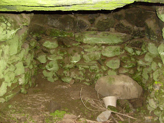


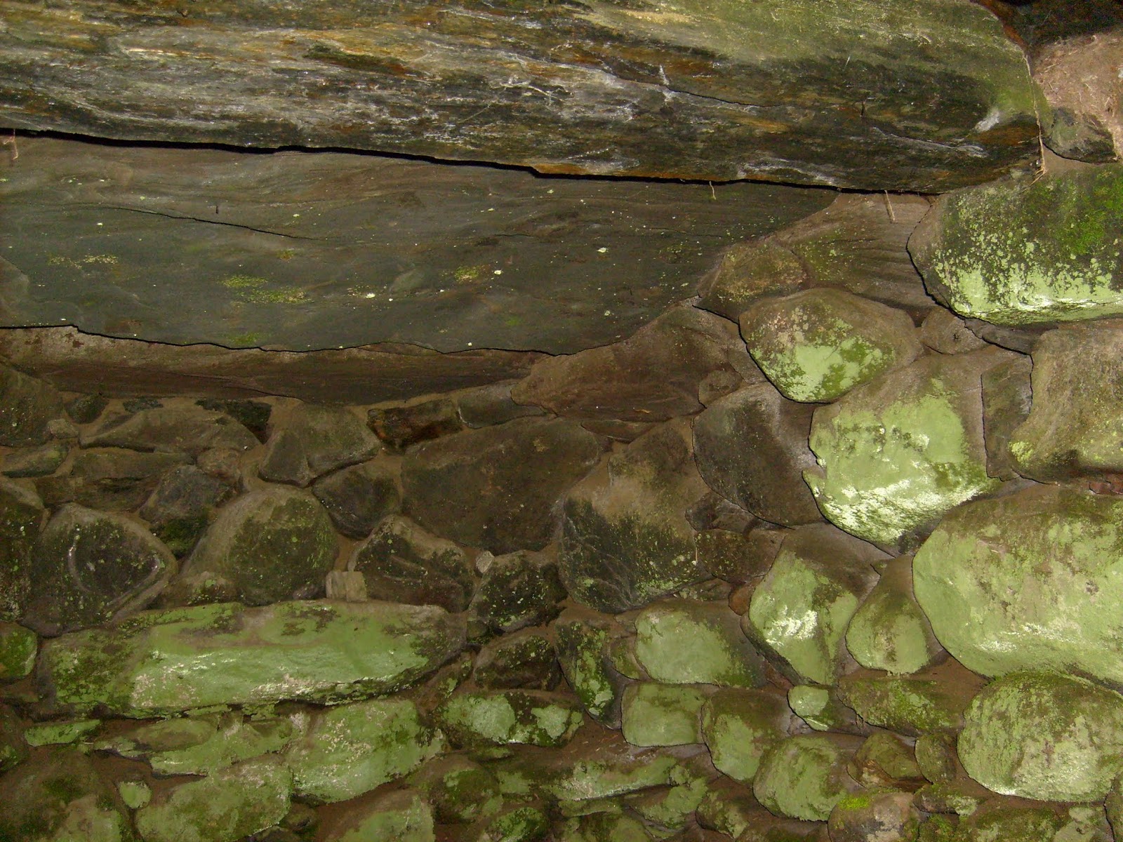


There is another stone chamber on the same side of the road in South Royalton, less than 1/4 mile away. That one is in the middle of a field perhaps a couple of hundred yards from the road. It's larger than mine, but I couldn't tell you the exact size.
Update: In a later email:
I stopped by the 2-door-down neighbor's house the other day. It's been at least 4 years since I saw the stone chamber there. The woman who answered the door is renting the house and gave me permission to look for it, but also stated that she wasn't aware of any stone chamber there. The field is pretty big, and I spent about 15 minutes looking without any luck. As I was walking back up, just behind the house was a pile of stones that looked like pieces of the slabs from the roof. I think the person who owns the property dug it up. This is the same person who put a trailer up in the once-beautiful field next door about 2 years ago. Sorry.
Update: In a later email:
I stopped by the 2-door-down neighbor's house the other day. It's been at least 4 years since I saw the stone chamber there. The woman who answered the door is renting the house and gave me permission to look for it, but also stated that she wasn't aware of any stone chamber there. The field is pretty big, and I spent about 15 minutes looking without any luck. As I was walking back up, just behind the house was a pile of stones that looked like pieces of the slabs from the roof. I think the person who owns the property dug it up. This is the same person who put a trailer up in the once-beautiful field next door about 2 years ago. Sorry.
Monday, September 23, 2019
Revisiting Quisset Wildlife Management Area in Mendon

The lower blue outline shows where I found a site previously (see here). Other places with rock piles were shown in the report but the major site was at that lower outline. Last Monday I went back with the plan to explore further to the north. So I ended up skirting the wetland clockwise and came across another major site, at the upper blue outline. Because of its relation to the nearby trail this new site is easy to find: from the trailhead at the end of Quisset Hill Rd., take the main trail and go right at the first fork, a few feet in. Follow this trail to the north, with a wetland to your right, and after about 1/2 mile the trail turns left and crosses a brook. Then uphill to a slight dip, as a higher water source drains away to your right (north) back into the main wetland. Follow that lesser, second valley north and you get there. The new site is placed similarly to the old site and skirting the wetland seems to have been a good strategy in this area. I would have found the old site that way and there are other spots with similar topography further north that may contain other similar sites. I'll have to go back. In any case, these sites are located on low ridges that penetrate the wetland.
I want to describe this new site in a bit of detail because it is a very classic mound-with-hollow, to one side of a collection of smaller satellite piles forming a grid - "marker piles". But here the satellite piles had a somewhat unique character: they were square, some having a larger "headstone". Here was the best photo:


The site was arranged like this:

The dots at 'a' and 'b' show mound and satellites. At 'c' there was a split wedged rock with its feet in the water (except it was dry) and at 'd' were a smaller pile and a twin rock-on-rock.
At 'c':
 At 'd', higher up, above the mound:


Now let's see some more pictures of the "square" marker piles:


Here are some views of the larger mound:


Covered with growth, it is a bit hard to make out that this is a rectangle with several hollows:

From above:


Panorama:

At first I thought I had stumbled back into the first site I found (lower outline above) but after walking around a while I realized this was a new place with its own special characteristics. All in all a beautiful and undisturbed site with many of the usual elements arranged in a unique way.
Wednesday, September 18, 2019


Sunday, September 08, 2019
Why not a Levallois Point?
Just making the comparison here, with a basic Levallois Point

(see video here)
The quartz flake I found matches this, flake scar by flake scar:
A bulb of percussion (last flake)

All the other flakes illustrated in the animation.


Levallois Points are from the middle paleolithic, right? This quartz item may have come from deep in the cape cod clay, so it is tempting to create a fantasy narrative about how this item got in my backyard. Whatever the mental contortions, it is a real rock.
Saturday, August 31, 2019
An interesting chip of quartz from my home dirt

At the risk of this blog becoming an "arrowhead blog", here is another example of an obscure piece of quartz from Woods Hole MA. It comes from the clay being removed for new construction at my house:

Of course it might have come from the shallow overburden of topsoil and be from the recent past, and since large equipment has been banging around in here, this man-made item could have been made in the last few months but there is some surface staining and enough flake scarring on all surfaces to suggest this must be a deliberate artifact. It is a delicate piece and the edge is still sharp - a very unusual piece of quartz.
A well developed "bulb of percussion":


Other flake scars and stains on the surface:


So you tell me.


Thursday, August 29, 2019


Friday, August 23, 2019
Opacum Land Trust (Sturbridge MA)

The mystery of the stone piles and structures that dot our
countryside will be the program at the 6th annual Opacum Land Trust fall dinner
happening on September 18th (2019) at the Barn at Wight Farm in Sturbridge.
Doors open at 5:30 pm- enjoy your favorite beverage, bid on our silent auction
(featuring local treats, treasures and activities), meet and mingle with Opacum
volunteers and supporters, and find out more about the important conservation
work of your local land conservation organization…

…Following dinner will be a program by Dr. Curtiss Hoffman
about his extensive research on the mysterious stone structures found across
our region, featured in his newest book Stone Prayers: Native American
Constructions of the Eastern Seaboard.

Join us to hear Dr. Hoffman discuss this highly debated
topic. Autographed copies of his book
will be available to purchase.
Tickets for the event are available through September 8th at
https://opacum.bpt.me/
or for more
information, visit www.opacumlt.org or call 413-245-1175. Proceeds from this
event support the conservation work of Opacum Land Trust.”

Wednesday, August 21, 2019
More quartz fragments from the Woods Hole Islands
I believe this piece of quartz is flaked:


If you accept that, then let me draw out the discussion a little and speculate that this is a broken tip from an arrowhead. At the upper left is a "tip" that is worn and rounded off. Here is a view of the other side, with the "tip" pointing upward:

 Do you see what I see? A groove from the lower edge up towards the tip. In fact there is also a shallower groove with the same orientation visible in the first picture above.


Lets take a look at the broken edge:
 So what do you think? Looks like part of a Clovis point. Back then, this area was above sea level and the "hole" and "gut" would have been valleys. Excellent spots for an ambush?

Subscribe to:
Posts
(
Atom
)
