I mentioned these in an earlier post [click here].
Was going to park on the road just east of the pond and head for the place where those three brooks meet, north of the pond. But I took a wrong turn and ended up opting for a different entrance to the woods, where Stone Street turns into a dirt road. This was ok as I had also planned to go to the wetland just southeast of the larger blue outline, in the map fragment above. So I parked at the end of "navigation" on Stone Street and continued north along the dirt road.
At the height of land the road crosses just to the west of the summit (see smaller blue outline above) and there is a wall next to the road. But at the high point there was also an extra isolated piece of wall or pile:
There was a faint depression running along it. I don't know what this is but, it being near the summit, I left the road to take pictures and then continued on through the bushes to the very top of the hill.
I half expected to see another rock pile up there. And there it was:
or, without the flash:
You can see it has rectangular elements - a corner in the foreground in this picture:
From further away:
I went back to the road and continued north and, it seems to me I found another similar pile but the lighting is so bad, I am not sure, from picture or memory, whether this is a second example.
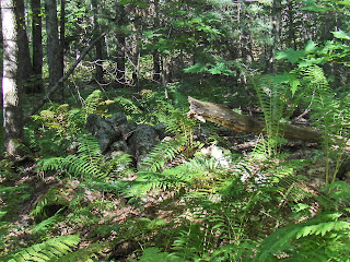
In any case, I thought it was time to head east, towards the brook confluence, so I headed off from the road, through the ferns. And within 50 yards stepped on another mound (see video here).
Some other views:
A fine pile that makes the effort worthwhile.
Apparently there were others as well in the ferns (roughly within the larger blue outline on the map). I had forgotten this one:
And this one with its satellite pile:
Somewhere else in these woods was a house foundation, without lintel:
And also more fine examples of rectangular mounds with internal structure:
Here is one that extended down an entire outcrop, next to a wetland:
closer:
After this, I gave up on trying to get to the brook confluence, went back to my car and drove to the originally planned spot. Entered the woods but was a bit tired and obviously I had already had a good walk, so I never did get to the brook confluence. Perhaps I got close to it, with the last pictures.
A fine place. It seems unfair to be in and out, take some pictures, and forget much of it just a few days later. So let us at least take a lesson: that the wetlands at the headwaters of brooks in these towns in north central MA (and adjacent NH) are a good place to look for mounds on knolls or outcrops that poke above the surrounding terrain. You may see rectangular elements of structure, and you may see craters. I think this is the Otter River Watershed.
Subscribe to:
Post Comments
(
Atom
)


2 comments :
This is the kind of place I'd like to explore in late October, early November, after the leaves have fallen, and preferably on an overcast day, which would make it easier to evaluate the mounds and hopefully see their relationship to each other and to the terrain. Interesting site.
If you are in the vicinity, we could go have a look together.
Post a Comment