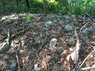
This is another pretty routine site discovery. Perhaps the best part of the story would be how I had decided to stay as close to water as possible (staying to the left in the picture) and gave up at the same moment that I was actually standing next to a rock pile:
I had gotten over to the edge of the wetland, as planned, and did not see much. These woods, especially along this wetland edge, had sketchy stone walls - almost broken into piles but barely meriting closer study. So when I got over here I am thinking "Well this is a disappointment....hmm that is almost a rock pile". Thinking this might be part of the loose wall, along this little ridge, I stepped a bit to the side (left in the above) and saw another -kinda- pile.
Just to be a little systematic, I stepped to the side again (left in picture), and prepared to call it quits, when something larger "loomed" in the distance:
Ooh baby! Let's have a look:
Quartz at the midpoint:From below
Beautiful. This mound and the smaller satellites were in a line along a ridge, actually an esker, next to the water. Here is a view, with a dirt bike trail in the foreground:
A bit to the right, was one other satellite, that I missed on the way in, and spotted on the way out.
That's it. My only comment is that this is like a marker pile site because the piles were, in fact, evenly spaced and in a line (the last pile was on a perpendicular line, if any) and the mound did not have a hollow. It reminded me of one other place off Red Coat Lane in Concord. As I look for a previous post on it, I found this site, also in Estabrook woods. But I cannot find the "Red Coat Lane" post - a mound like the one in today's report - also an oval with satellite piles next to the water. If you cannot find the report, enter the woods on the private trail on Red Coat Lane, and keep your eyes peeled as you walk in. The mound is on the left in the first 1/4 mile.


2 comments :
Peter -
This is in the Charles watershed, near the headwaters of Mill Brook.
I see. Thanks.
Post a Comment