Showing posts sorted by relevance for query Woodbridge. Sort by date Show all posts

Thursday, February 26, 2026

'The Indians' of Woodbridge CT


Sheila McCreven

 "In the book, 'History of Seymour, Connecticut with Biographies and Genealogies' published in 1879 by W.C. Sharpe, in a chapter titled 'The Indians' on page 36, the following passage provides some details connecting the native people of Seymour and Woodbridge...A small group of hikers set out to visit the last known settlement of the Paugussetts on June 29, 2024...the group of hikers soon locate the area, enclosed by a fieldstone wall with its entrance marked by two stone pillars, each with a capstone bearing an inscription — the words “Paugassett Indians” on one; and “Last Settlement 1833” on the other...Woodbridge Town Historian Marvin Aarons tells the tale:

"According to Woodbridge resident Edee Lockyer, who visited the cemetery as a child in the 1940s, the graves were then mounded up and covered with rocks. Sadly, the graves were repeatedly disturbed over many years. Today, there are no gravestones or burial mounds; rather, the grave sites are sunken."


https://www.townhistory.org/the-last-paugassett-settlement-on-the-border-between-woodbridge-ansonia-and-seymour-2/


Tuesday, April 12, 2022

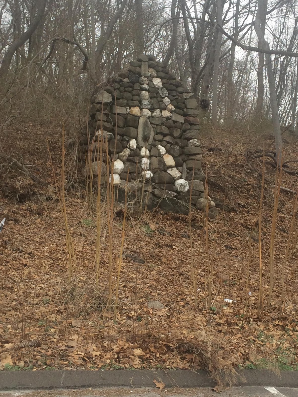
Woodbridge 3 - "Crescent Cairn" at Elderslie Preserve

The main Woodbridge experience is within the "Elderslie Preserve". Check out the nice Woodbridge Trail maps. They indicate this feature and I was expecting a wide old crescent remnant of a mound with hollow. But no, this was more like an oven:

Here are some photos:


Note quartz in the corner:
Note the amount of soil eroded away below the structure.

I would say this is a unique structure but I have seen something very similar before, behind the main school building at Barlow School in Amenia, New York. The school is gone but I suppose the rock pile is still there:

See here.

This example in Woodbridge, off Orchard Rd, seemed blackened on the inside - which is why I suggest it is some kind of oven. But I do not know. I was struck, in Woodbridge, by how much soil had eroded from around the base of the structure.

Monday, February 24, 2014

Two Bits about Woodbridge CT

It happens from time to time that while looking for something else I find interesting little bits about something entirely different, cleverly disguised in the tables of contents in the plain text format at Google Books as: THE TOWN OF woonnRmuE.  in: The History of New Haven County, Connecticut, Volume 2  edited by John L. Rockey, W. W. Preston, 1892 
"Though the Judges' cave on West Rock is just without the limits of the town, still there are several locations which have a historic interest as places to which the regicides fled, or where they secreted themselves, and were aided by the early settlers of Woodbridge. There are several places which bear names evidently derived from their having been the residence of the exiles, such as the “Lodge," the “Harbor," the “Spring," " Hatchet's Harbor," and others. Of these places the Lodge was probably the one most frequented by them. This was in the northwest part of the town. Reverend I. P. Warren, in his history of the three judges, thus speaks of it: “Here by the side of a ledge of rocks, some 20 feet high was built a cabin of stone, 9 by 10 feet in dimension and covered over by trunks and leaves of trees. From the top of the ledge is a fine view of the city and Long Island sound, with the intervening villages and scattered farms and dwellings. A little spring of clear water issues from the crevices of a rock a few rods distant." “This," says President Stiles, at one time president of Yale College, “ was undoubtedly their great and principal lodge." The “Harbor" was about three quarters of a mile above Halsted Bishop's, on the stream across which the New Haven Water Company have built their large dam. Another hiding place was with Mr. Richard Sperry, the ancestor of the Sperrys, once so numerous on the flat known as “Sperry's Farm." It is evident that to Woodbridge and its inhabitants, as much as to any other place or people, the regicides owed their escape from the emissaries of Charles the Second, who had come over from England to apprehend them..."
If someone's detective work led them to believe this was the "twenty feet high" "stone cabin" described above as The Lodge, I would seek a second opinion of a second detective:
"Stephen Peck Perkins learned the mason's trade and became a prominent contractor in the city. He was a skillful and thorough, workman. There was never a question but that work entrusted to him would be done well. He retired from business and built an elegant villa in his native town near the old homestead of his childhood..." 
The old Peck homestead of his childhood?
Note Peck Hill Road in the distance...

Tuesday, April 12, 2022

Woodbridge 1 - Peck Hill from Coachman's Ln

The first of several short hikes around Peck Hill, in Woodbridge CT. As it turns out there are two natural corridors that lead here from the Naugatuck River - one a broad valley leading north east from Ansonia, the other Bladen's River. Peck Hill, also known as Judge's Rock Hill, is a steep ridge between these two approaches - holding some of the springs that lead down to rivers and the sea.

By way of an overview, in the last week, we visited sites in eastern CT, western CT (Woodbridge), eastern NY, and central NY. I saw familiar items in all of these places but Woodbridge was a little out-of-step with the others. Everything seemed quite old and there were three or four types of feature in Woodbridge that I never saw before. More on that later. 

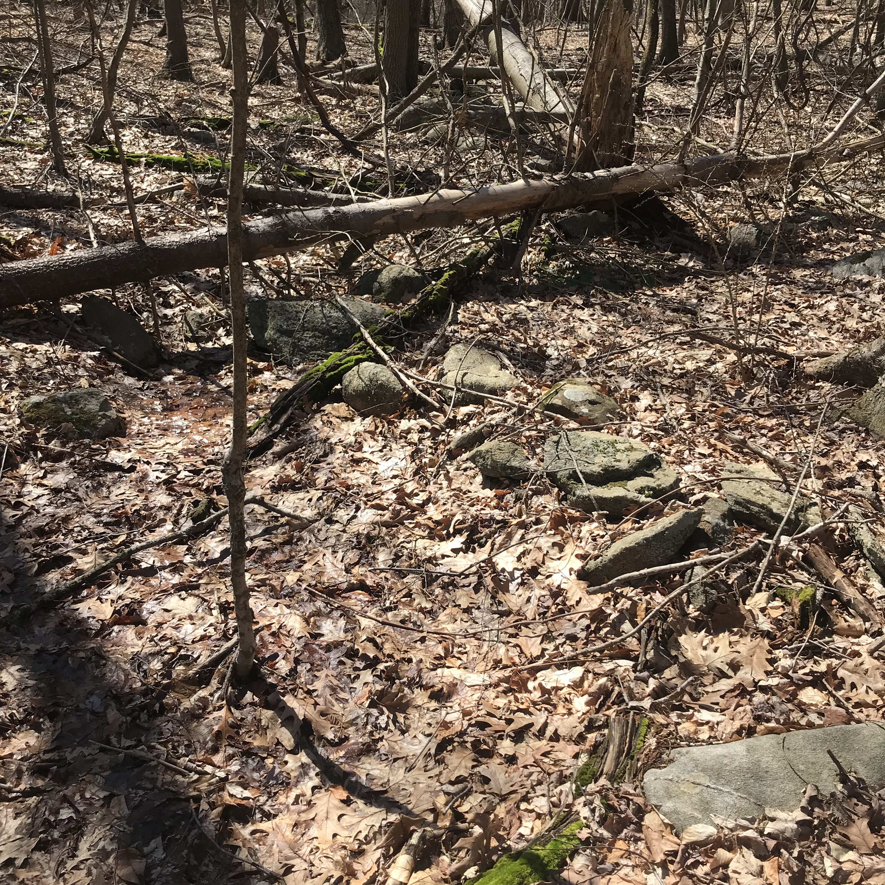
Here is a brief view of the first site we visited. We were driving around backroads and found an entrance to the woods off the side of Coachman's Lane. At the top of a steep climb we found the blue-dot trail a few yards east of the main "rock", as shown in previous post. Then a few yards further east, we found a nice site at the junction with the orange-dot trail coming up from the other side of the hill:

Detail:

I am going to say these:
are possible marker piles.  

And a few possible "mounds with hollows" of the oldest (small and beaten down) type:
This is a bit of a "lazy 9" style.

Nice piles, built on the ground and along the outcrops:

And many more:
Barb captured the essence of the place. Lots of things going on, hard to say any rock is not part of it.

Thursday, September 08, 2011

Woodbridge

(An older Photo from Elderslie in Woodbridge CT)
I was just reading about Seymour CT in an old issue of The Connecticut magazine: an illustrated monthly, Volume 6 edited by William Farrand Felch, George C. Atwell, H. Phelps Arms, Francis Trevelyan Miller (1900). When I came across this: "In 1731 they bought of the Indians all the land known as Indian Hill, in Derby, situated upon east side of Naugatuck river near the place called the Falls; all the land that lieth eastward, northward and southward, except the plain that lieth near the Falls up to the foot of the hill." This deed was signed by John Cookson and John Howd and other Indians. Indian Hill included what is now known as the Promised Land, and east to the Woodbridge line (http://books.google.com/books?id=kvQLAAAAYAAJ&dq=%22the%20fishing%20place%20at%20Naugatuck%2C%22&pg=PA315#v=onepage&q=%22the%20fishing%20place%20at%20Naugatuck,%22&f=false)."

It reminded me that I meant to post that I had visited, camera-less, The Elderslie Preserve in Woodbridge, near the Seymour town line (sort of). I was on the way home from the New Haven Train Station, just after Hurricane Irene. I took an hour long walk through the woods off Peck Hill Road, looking at some Rock Piles I had seen before and many that were new to me. There was little storm (or earthquake) damage and once again I was impressed with the great number of stone monuments in the preserve to the west of the boyhood home of "PWax."
(I made a clockwise circle along the western edge and returned by the red trail, stepping off of it to see the "new to me" stone heaps...)

Saturday, November 26, 2022

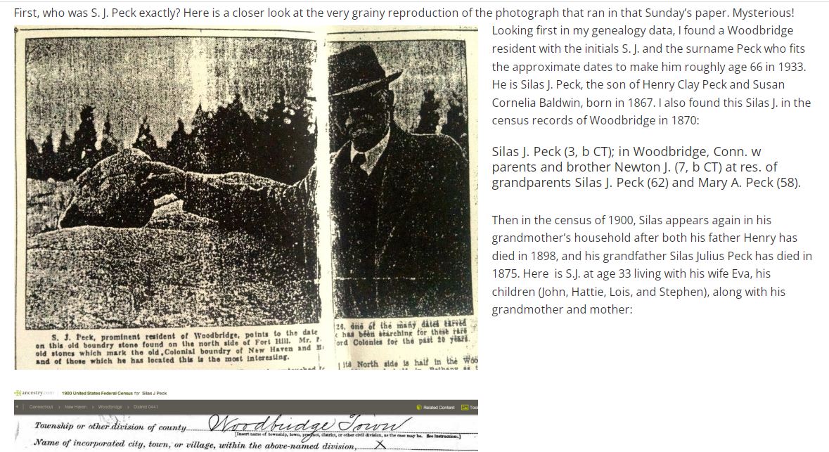
Battered Boulders All That Remain Of Famous Boundary


Carven Field Stones Amid Woodbridge Thickets Stand as Silent Guardians of Line Established by First Colonial Surveyors — Penalty Prevents Removal

New Haven Register November 26, 1933

 “It seems that back in 1933 lifelong Woodbridge resident S. J. Peck had finally uncovered a bit of Woodbridge history he had been searching more than 20 years to find — one of the boundary stones set out in 1672 to mark the border between what was then the Milford Colony and the New Haven Colony. These two colonies each held claims to the land that would one day be joined together to become the Town of Woodbridge when it was established in 1784. 

http://www.townhistory.org/ancient-boundary-markers/

 Looking at my photos, I observe that the 1933 newspaper image has been reversed when I match it up with my looking in a southerly direction capture: 

Sunday, March 02, 2014

Waiting on Woodbridge

    While I am sort of busy looking out for what stones emerge first from under the melting and then refreezing snow, I’m also looking at old files of photos from Woodbridge CT, most of them from late Spring of 2009. The former activity is a little hazardous as I drive and sometimes stop along narrow, frozen snow banked roads along the back roads or glimpse them from the interstate system but there’s so much I never noticed before, rows of stones running up to outcrops or possibly large boulders. The latter activity is the much safer of the two since I pose no hazard to navigation sitting in front of this screen…
    I’m also doing some “recon” on a little hill in Woodbridge where a bit of Blue Trail loops around it, where a few spots have caught my friend Peter’s eye
 – and my interest is peaked in some of the same spots, those little round bumps on little wide and relatively level places between the contours, the wet and swampy places. Since it’s all snow covered, I’ve been gawking at some aerials from different sources – and so has my friend dc. And I find we too share some spots that catch our collective eyes.
     Since I’ve been to the Preserve that shares a parking spot with this one, I don’t doubt that there’s something there, but I wonder if it could be just as jam packed with features such as I’ve see there…

The first screen capture probably won’t impress you much:
That’s a “Bird’s Eye View” from Bing maps. Change the direction of view and suddenly things jump out at you – the river obviously, but also boulders and stones in an area it’s doubtful that anyone ever plowed or cleared field stones from and some massive looking rows of stones as well:
There’s no way to get much detail from these images (poor as they are), but that is an impressive couple rows of stones. How bad is this image below?
But on the hill side to the south of this unnamed hill is what PW calls the Judges Woods, I’ve been walking about there several times and I've seen some similar looking rows where shapes and possibly artistic placement, maybe even with some rock carving/shaping activity might have happened too, makes me think, “There’s that Indian Look” - again."
   Again from Bing, here below is just one such spot that resembles it: 

   And suddenly, as I write this, I remember this: http://rockpiles.blogspot.com/2009/09/searching-for-serpent.html and feel like I should sometime return and check if there is an interesting large boulder at the end of both these segments of carefully stacked stones that look like this on the ground:
To get back to the boulders, here’s one “concentration” or “segment” that I may not have posted before from my very first visit to the Preserve, over by Peter’s childhood home:

 That first word that popped up in my Ink Blot Impression area of my brain was “Mountain Lion.” And the word “couch” came up for that boulder next to it – mostly because there’s a similar shaped stone perched on top of a huge boulder at Chimney Cave in Watertown CT, part of the Old Hunting Caves, now better known as Leatherman Caves. But these Woodbridge boulders are “linked” (and if you say that it’s some colonial livestock fence and nothing more, I will wiggle my eyebrows like Groucho Marx and quote him as I say “I can’t say that I don’t not disagree with you” about that…):

And your view of the bigger boulder, as you move toward that couch, may no longer remind you of a Puma, but possibly another sort of animal that may have been purposely enhanced by the same kind of animal perhaps:
 
Interesting edge on the back rest part of the 'couch:'

Sunday, April 03, 2022

DIFFERENCES: Way out west in Woodbridge CT.

I am taking a long drive with my wife, stopping and taking walks along the way. After two days of hiking in southwestern CT, the land of the Paugusett, let me mention some differences between here and "back home" in Middlesex MA. Come to think of it, examining differences between here and there is one of the main purposes of taking this long drive. I assume that there will be differences that reflect differences in the history of these places. So without further ado:

There are no large rectangular mounds with hollows. All I see are faintly rectangular outlines on the ground. I suspect these are one of the oldest forms of burial.

While looking for other photo examples, I was looking for outlines and, otherwise, would not have noticed this, in another photo (from Cockaponsett State Forest in MA)
A lesson in how you see what you are looking for (and miss it otherwise) is noticing the oval outline in the middle of this structure. Maybe this is a viewing platform and that inner "circle" was a place to sit? Also this is a lesson in how each little rock is part of the picture and should not be ignored.

Speaking of outlines, there were three examples of a small circle, that are not something I see back home [at least not often]. More on these later:

Anyway....back to the differences:

Everything I am seeing in Woodbridge CT is broken down. Also the piles are made from larger component rocks than the average rock component size back home. Everything being broken down qualifies this as a true "signal". These places are all old compared to Concord and vicinity. Back home we have old, broken down, large component, piles. But we also have many that use smaller rocks. The uniformity of the degree of damage, suggest this "older" southwest CT culture was uniform. In Concord and vicinity we have nothing but variety. The "signal" here in CT is pure and uniform.

Everything I am seeing in Woodbridge is relatively small. Nothing larger than 16 feet across. I am sure there are such thing but I would have seen some by now if they were common down here. 

And then, I am seeing a number of things (especially with Tim MacSweeney pointing out some things I would have missed) that are unique and unfamiliar to me. Namely: lots of "cup marks" in the boulders; a ziz-zag stone row, directly in a spring and heading down hill as a brook forms to one side; and a few suspicious dirt mounds that might not be modern. I'll cover these things more in later posts. But for now, some cups:

The beginning of a zig-zag:

A dirt mound in the background, suspicious because of the rock pile closer to the camera.
This is across from 485 Bethmour Rd in Bethany CT. Saw similar mounds elsewhere but did not photo, they were suspicious for another reason. [Somewhere between Rimmon Rd and the end of Osbourne Ln, possibly along Ford Rd, there is a pond with two identically shaped mounds, next to the pond. Later I was sorry to not have taken a photo. What was slightly suspicious was that there were two earthen mounds. If it was dumped sand, why have two? And why next to a pond? Suspicions but nothing concrete.

Other differences may have slipped my sleep-deprived mind.

Took 70 photos yesterday and about the same number on Friday. Lots more posting to do.

Saturday, July 25, 2015

Strange rock pile from Woodbridge CT

From a reader in CT:
I am curious as to what the story is behind this rock pile in Woodbridge, CT.  The location is at the corner of Schroeder Terrace and route 63.  You can see the location on Google Maps at https://www.google.com/maps/place/Woodbridge,+CT/@41.344537,-72.985604,17z/data=!4m2!3m1!1s0x89e7dbf9d23cf7df:0xc3970065bcfa4cf0
Any idea what this is all about? 
Thanks!
STEVE F.

Wednesday, April 13, 2022

Woodbridge 4 - Things I saw that were unusual

While walking around the Elderslie Preserve in Woodbridge, CT. I saw several things I am not used to seeing. I thought I would mention them explicitly. These are some of the ways that Woodbridge is "out of step" with the typical sites I see. This might be because of the Paugusett who lived there, or for other reasons. I might not have noticed these things, except that Tim MacSweeney pointed out some of them. Here are some unusual things:

Stone circles, by a foresight:


In all cases there is a feature, I am calling a 'foresight', that is adjacent to the circle. It is hard to not assume they were used together.

Wall dips:
I showed one yesterday from Bladen's River, CT Saw another at King's Chamber in Fahnenstock, NY.
What looks like part of the wall, at the low point of the 'dip', is actually a rock pile beyond the wall. Look closely at the different focuses. There is a pointy rock in the wall on the right side of the dip. I imagine it's shadow hitting the pile behind the wall, perhaps going through the hole? That might even be a piece of white feldspar built into the dip, like the dip had quartz in CT.

Zig-zag "snake" in a spring
(Tim MacSweeney's photo, me and my wife in the background)
While Tim was taking that photo, I was taking this one:
Hard to make out. Tim pointed out how the brook was forming to the side of the zig-zag:

Manitou stone at a wall end:

Cupules
These little divots in the rocks were completely unusual. For one, these holes are not symmetric and many are too small to serve as mortars. For another they are not always on a horizontal surface. For another they seem to form patterns on the surface:

To call these "mortars" would be a failure of observation.
[Here, Tim warned me about climbing on the thing. I took a chance to get a better photo. When I watched Barb's video, later, I noticed some helpful little stepping stones to help someone get on top of the rock. So I do not feel so bad.]

Note the vertical surface:
What are these?