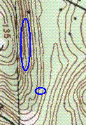
 I noticed a piece of woods on the topo map. I had explored it before but not thoroughly and I saw that if I headed north, rather than east from the obvious parking, then I would be in a new place. It turned out to be a small valley with a brook, a surrounding alluvial area, a steep hill on the west side and a more gradual one to the east. I planned to walk in on the east side of the brook and cross where possible, explore some of the west side of the valley, then loop back over to the east side and explore what I missed on the way in.
I saw a small damaged rock pile next to a stone wall, nothing too dramatic, and I was scanning the woods for something more substantial. I saw this on the far side of the brook. Surely a man-made tumble of rocks.
 You can see there are lots of loose rocks behind this. I could not make much sense of it except that it certainly included some remnants that looked like rock piles:
 This is on the other side, looking back towards the brook. Here is another similar view, looking past a different pile:
 But I do not know. There were too many suggestions of structure to be confident what I was looking at. Maybe this was not originally rock piles? After all, rock piles are what you get in any kind of a ruin. I could not tell for this place. Here are some of the tumbled rocks suggesting an unfamiliar structure:
 This site is represented by the smaller blue outline on the map fragment above.
No comments :
Post a Comment