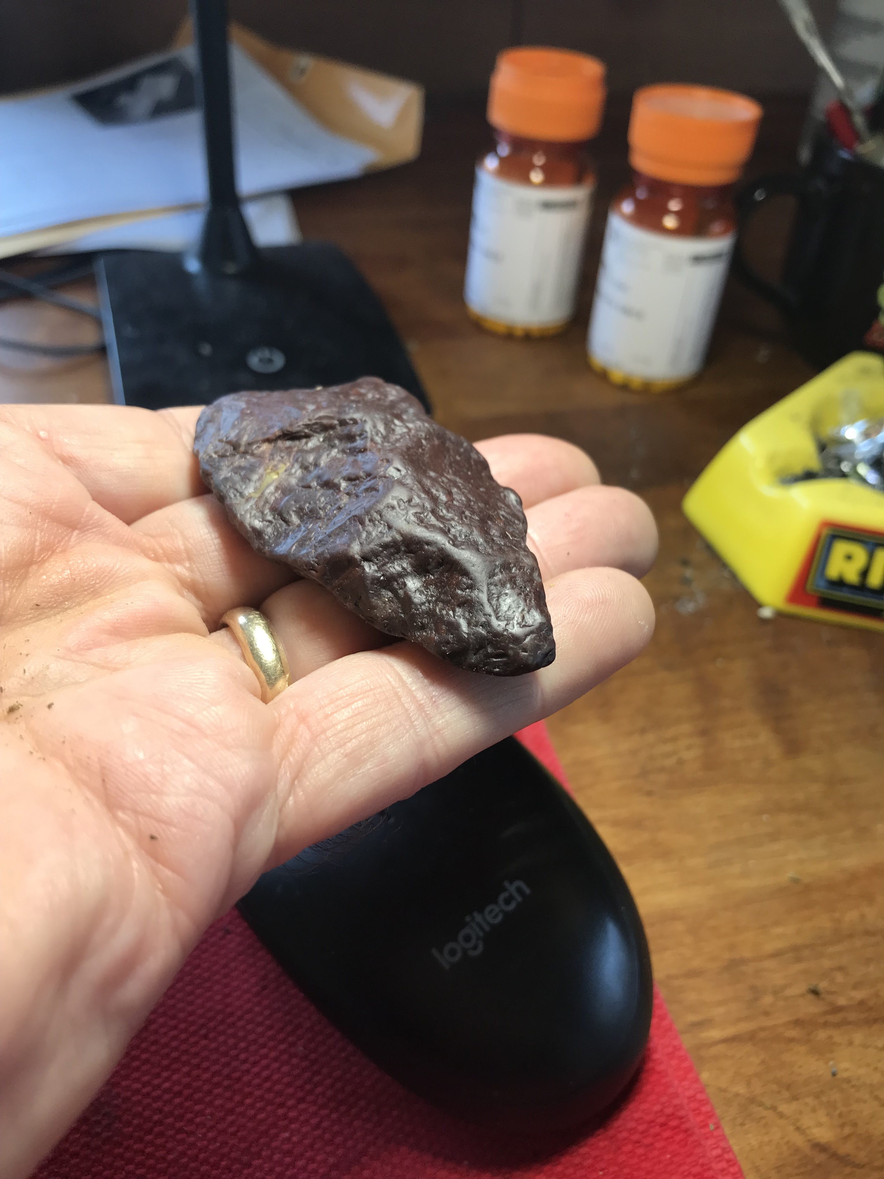
Found some nice little argillite points:


I am quite taken with the nice proportions and careful flaking of this little point.


Found some nice little argillite points:
Found in Rhode Island, these are quite similar:


It is hard to escape the sense that there is more archaeology visible on the surface in the Arctic than will ever be comprehended by anyone:

From Tim MacSweeney's Waking up on Turtle Island:
Waking Up on Turtle Island: Former Row of Big Boulders (Part Two)
It is about time this idea got some supporting evidence.
Native Americans—and their genes—traveled back to Siberia, new genomes reveal | Science | AAAS
By the third paragraph, the evidence-free discussion begins but at least an obvious idea finally gets voiced. This is Science magazine, so I do not know why they remain stuck in the what is essentially a 'Clovis First' paradigm.
I have started to be more clear as to why I think this is a legitimate arrowhead. For example consider the symmetry and flaking:


From James Cachat and the Massachusetts Ethical Archaeological Society:
DOT is meeting tonight with the City of Northampton because they plan to move forward with their project on the unique ancient site in Nayyag. This site was recommended for the National Register of Historic Places by DOT's own archaeologist.
Despite disinformation by Ms. Misch of Northampton gov't., the facts of this case are named in the attached report, along with the actual statements made in February 2021 by DOT officers and questions from the public.
Tonight at 6:30, DOT is having a meeting in Northampton that can be joined by remote. The news report says 6 pm, but the state site says 6:30.
To join, go to: mass.gov/event and look for this meeting. Follow instructions there.
Mark Anderson, Tribal Cultural Resources Officer for Aquinnah Wopanaak (Wompanoag) has stated on record that this site should be perserved and that it appears to be a village site.
Narragansett Tribe also stated in newsmedia their concerns for preservation at this site early in the process.
DOT is not reporting either tribe's statements in public messages.
DOT admitted in the Feb., 2021 meting (as detailed in link below) that:
1. Traffic circles increase the number of accidents at a given intersection.
2. The place concerned here had a below-average rate of accidents in the 5 years studied previously.
3. There are 0 fatalities on record for this intersection.
4. There are several known archaeological sites less than a mile from this site.
5. The site was recommended for inclusion in the National Register of Historic Places by DOT's own archaeologist.
6. Only a couple of years earlier, DOT demolished another ancient site, 8,500 years old, less than a mile down the road from this site.
7. A traffic light can be installed at this intersection.
8. The most accident-prone intersection in the entire state - and the world - is a traffic circle in Longmeadow.
[from the megalithic portal via Tommy Hudson]
Foxborough Stone Ring
Country: United States Topic: Neolithic and Bronze Age
Do we have any readers living near Foxborough or Wrentham, between Boston and Providence Massachusetts? There are dozens of strange rock formations in this forest to explore. More information and links on this page - please send photos!. A curious ring of stones in F. Gilbert Hills State Forest (also known as Foxboro Forest) . Possible pointer stone at base. Dimensions of the structure are 8 feet long by 6 feet wide. About 1/2 mile south off of the Megley Trail on trail indicated on map. Located on the left hand side, about 200 feet off the trail, very hard to see. Recently made stone pile nearby.
http://www.megalithic.co.uk/ar
All the physical evidence of my glass "arrowhead" (here and here) points to it being obviously a deliberately flaked and used piece of glass. And yet the average impression, including my own, is that of course it is not real but just a coincidence.
This is an opportunity to take a close look at that sense of disbelief. It is quite similar to the disbelief that an Indian could have made a rock pile during the last 400 years. One main point of this blog is that Indians, at all times, have made stone constructions. We hear this, we believe it, yet we still do not - in our heart-of-hearts - really understand it. We are quite ready to abandon our own logic. For example, I do not think we grasp just how poor some Native Americans were. How can you be so poor you cannot afford a metal knife?
I am starting to think maybe glass arrowheads are not so rare - just like those pesky unbelievable rock piles. When I go poking around on "arrowheads.com" and "reddit/r/Arrowheads" a small number of other people report finding flaked glass at sites they usually prospect for older items. So it really is a thing.
I think the edge use is definitive. The only other part of the edge with these small facets is the inside of the bend on the "stem".

First, compare these pieces of broken glass found adjacent to each other, in a plowed cornfield. I took the photo because it is so clear that the piece on top is different:


As I've said: everyone loves nice flaking. You can see why it is worth keeping, if only to speculate about how many different blows and pressure flakes it took to make this bifacial object:

It sure is pretty. Real or not, it's going in the collection.
The thick glass reminds me of a soda fountain milkshake glass. Actually, also thick Sandwich glass. I don't know how old that could be but, within reason, Indians with knowledge of knapping might have overlapped with the availability of glass for few hundred years. People on Arrowheads.com say Indians were knapping glass at least into the 1890's. The famous "ISHI" lived till 1916.
Other people find similar things occasionally. Here is a beauty:
https://forums.arrowheads.com/forum/general-discussion-gc5/native-american-arrowheads-other-lithic-artifacts-gc7/7636-historic-glass-arrowhead
I decided to get a little cagey about this place. For one thing, every single feature I think is man made could easily not be or be modern. But check it out:


In April, I went with my wife on a driving expedition that took us to Woodbridge CT [numerous articles] and to Kings Chamber in Fahnenstock NY. A superb place.
This was part of a move to get off of Cape Cod and see a few things; which continued after we got back, with my driving over to Freetown during weekends and discovering a few rock pile sites over there. I did not find the places Mavor and Dix describe and, clearly, the town has more to be revealed. I took a few other hikes in parts of Rhode Island adjacent to MA.
In August I started looking for arrowheads again. This was a combination of some obscure finds from the harbor islands of Woods Hole; along with Chris Pittman showing me how to use aerial photos to spot likely farm fields. I have been driving back to the mainland ever since, to explore such places. Finally, in Raynham, I found my first "independent" arrowhead by that method. Your mind is challenged to find a worthwhile location, your eyes and patience are challenged to see what is there. The more willing you are to ask permission, the more places you have to look.
I have thoughts about the general philosophies of arrowhead hunting. Out West the ground is bare and the only problem is to choose a likely topography. Here in the East there are only a few spots of bare dirt left. The coastline is one dimensional and privately owned. Most of our creeks and rivers are completely silted-in and surrounded by muddy marshland. So it is hard to find anywhere worth looking for arrowheads here. I think the guys out west have it a lot easier. And don't get me started on the lack of knap-able materials, available in the glacial gravels down here.
Finally, in the last few days I spotted what looks like a large pyramid shaped mound in the southeastern AZ desert. This just makes me want to go drive around the west more and more.


Not sure why I bent over and picked this up:

So I turned it over, hoping to see the sharp edge of a celt. Not entirely disappointed to find the curved edge of a gouge instead:


OSU archaeologists, on Idaho dig, find oldest known projectile points in the Americas - KTVZ
[Re: peopling of the Americas]
Ancient Humans May Have Sailed The Mediterranean 450,000 Years Ago : ScienceAlert
The assumption that all of our early pre-human ancestors were too dumb to walk and chew gum, seems pretty typical of a field dominated by the European male.



First in a long time, since retiring and looking for new places to hunt. I do not really count the ones from places that Chris P. showed me (see here). I found this location all on my own by looking at aerial photos and following the strategy which Chris taught me: it is about farms next to water.


I never pulled it off but have always believed it would not be hard to prove a field clearing pile had (relatively) random sized rocks - a uniform probability distribution for the different rock sizes. I stumbled over my inability to measure single rocks. When I first thought about it, I also realized that an excessive number of small flat rocks could be a signal for field clearing. Just now, I heard another one: that the collection of piles making up a field clearing pile "site" is itself a mess: piles of different shapes, piles of different sizes, piles on top of each other, piles with large, medium, or small rocks. It is not hard to see when a site is from field clearing.
[Not rock pile related]
I was driving around the "Head of the Bay" in Bourne, at the top of Buzzard's Bay. It occurred to me that where they dug the Cape Cod Canal, from the north to the south side of the cape, there was a natural series of lakes and waterways that did some of the job.
This route followed by today's canal was probably a travel corridor in pre-history. In fact, as I was driving around on Bournedale Rd there was a sign saying it was an "Ancient Way" and that I should drive carefully. [Not sure if reckless driving is a threat to the archaeological record or to the mood.]
Since they found lots of arrowheads at the southern end of this corridor, near the Aptucxet Trading Post in Bourne, I figured a good place to hunt plowed fields would be up at the Head of the Bay. Well, there were a few places visible from the aerial photos but they were either all grown over, or fenced in as part of very private farms. But as I drove back and forth checking several different places, I passed a cranberry bog several times (the one with three conspicuous windmills, that you see from Rt 495) and, eventually, thought I could spend some time looking around the edges of the bog - where they had been bulldozing not too long ago. I mean, if an ancient site is going to show up anywhere near here, it is most likely to show up in a cross section that really goes down into the glacial sands.
After looking around the edges of the bog, I was wandering around random piles of dirt and saw this:


But wait! Maybe the break is in the lower left of the previous picture and the lower right of this picture:

So maybe, if you are willing to spend an hour walking around newly bulldozed sand in a cranberry bog, you might find - at least - a broken quartz stone tool. It could be any age. But just because the sand is being mixed up by the bulldozer doesn't mean the find is not more or less in situ. Meaning it really is what it is: a stone tool in the glacial sand.
Did it start out on the surface or was it some depth in the sand? Well, I am not an expert but there are a couple clues. One: no weathering. Two: bits of orange (iron?) stain that have migrated into the superficial cracks on the surface of the quartz.
The long and the short of it is that this is not a completely crazy arrowhead hunting strategy. I have been eyeing some new bulldozing going on at the cranberry bogs along the Coonemessett River in Falmouth. Arrowheads are cool (and certainly what I am hoping to find) but a little bird is telling me that there could be a deeper story.
Along CA 168 near "Gilbert Pass" southwest of Fish Lake Valley at the north end of Deep Springs Valley.
What the heck is that circle?


While walking to the mailbox, I had another Serpent Surprise...


