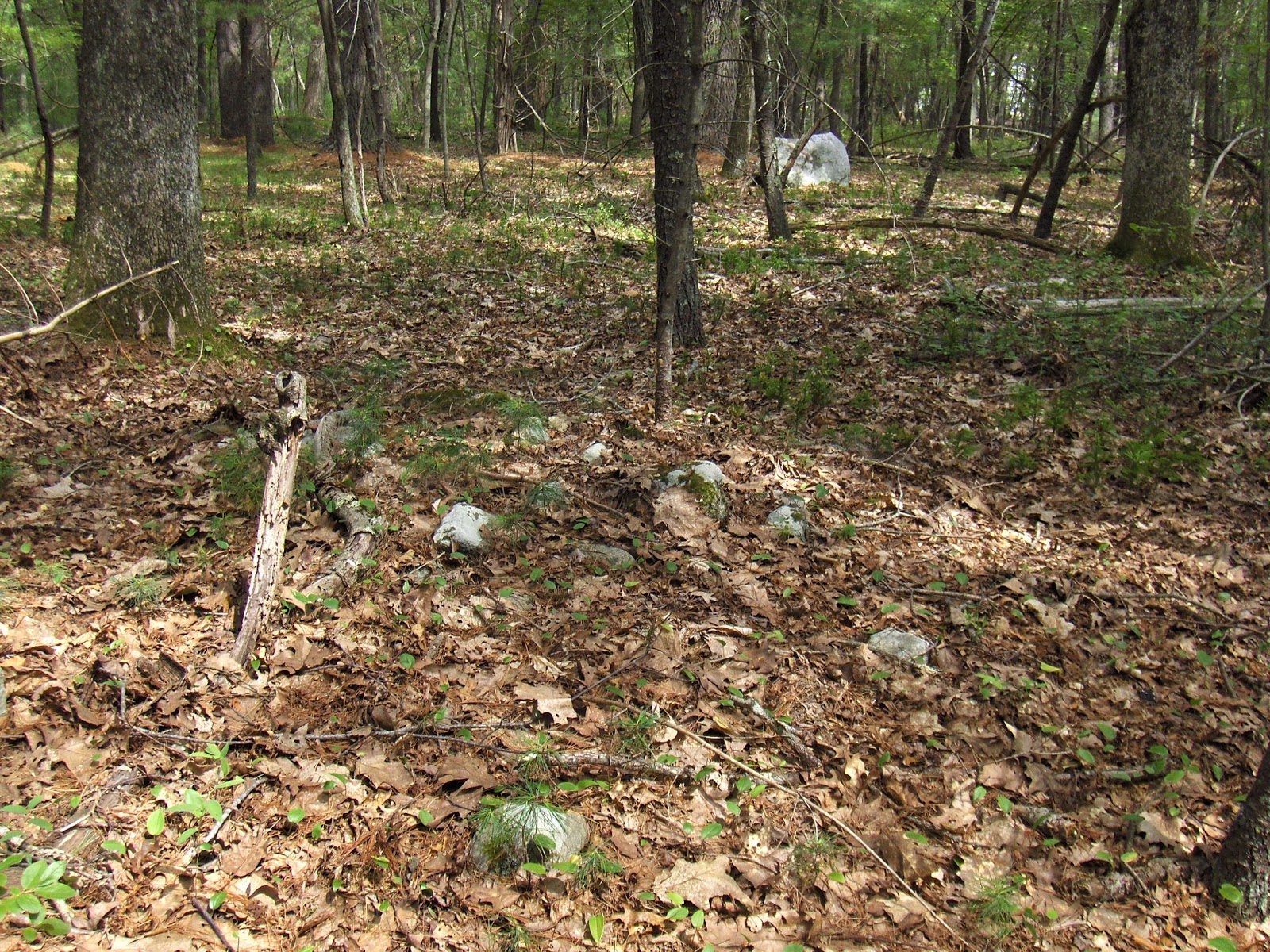
I stepped into this woods from the southeast (there is a little parking area) and saw stuff immediately - although the topography is flat and not very promising. You walk in along a dirt road. On the right...
...a little curve of stones,
a split-wedged rock:
On the left, as soon as you come to a low place with water draining (southward) there are big messy piles that are adjacent to large pits that appear to be from sand/gravel quarrying for the road. The big piles look like discards:
But they are adjacent to smaller ones that really look closer to being ceremonial. Eventually, I convince myself that at least some of it might be ceremonial:
Is that internal structure in the larger piles?
Finally, I have no further doubts:
This cluster is within 60 yards of the entrance, on the left.
Looks like structure to me:
More long messy berms:
More isolated piles, grouped within view of a nice small boulder:
Ceremonial with a backdrop of suburbia:
I am sure I just scratched the surface in this park. I never got to the higher land further west I had been planning on getting to. Saw too much stuff before that.
Yeah....that's structure:
[Blogging from Berkeley CA. I did not see the walls yesterday, although we went looking.]
Saturday, August 01, 2015
SC Terraces
"The first item of
interest that we saw on our trek towards the waterfall was at the area I have
labeled "Area With Rock Walls". We were in an area of fairly open
forest, with the terrain heading gently, but steadily uphill, and saw an area
with multiple rows of rock walls, each higher up the hillside than the one
before. Andy counted eight different rows of walls. Perhaps a terraced garden in
years past?"
"More photos in my SmugMug Gallery. Also, be
sure to check out Andy's set of photos, as he got some shots with really
great perspectives on the waterfall..."
Friday, July 31, 2015
Stones in South Carolina
"While hiking in the Sumter National Forest, I encountered several rock piles, cairns, caves, and monoliths, which a prudent person would consider to be of some archaeological value. In some cases I took pictures of them, as well as GPS waypoints. But I always left them untouched. Hiking and taking pictures in Sumter NF does not require a “permit." http://www.meteorite-times.com/bobs-findings/the-whitmire-south-carolina-bolide-of-february-13th-2012-the-search-for-meteorites-from-this-fireball-meteor-still-continues/
“A village and its surrounding territory were important elements of personal and collective identity, physical links in a chain binding a group to its past and making a locality sacred. Colonists, convinced that Indians were by nature "a shifting, wandring People," were oblivious to this, but Lawson offered a glimpse of the reasons for native attachment to a particular locale. "In our way," he wrote on leaving an Eno-Shakori town in 170I, "there stood a great Stone about the Size of a large Oven, and hollow; this the Indians took great Notice of, putting some Tobacco into the Concavity, and spitting after it. I ask'd them the Reason of their so doing, but they made me no Answer." (22) Natives throughout the interior honored similar places-graves of ancestors, monuments of stones commemorating important events-that could not be left behind without some cost (23)…”
The Indians' New World: The Catawba Experience ~ James H. Merrell http://dp.crlt.indiana.edu/jay/5th10thpics/merrell.pdf
Foot note 22: Lawson, New Voyage, ed. Lefler, 57. { http://docsouth.unc.edu/nc/lawson/lawson.html }
Foot note 23 (stone monuments): Edward Bland, "The Discovery of New Brittaine, i650," in Alexander S. Salley, ed., Narratives of Early Carolina, I650-1708 (New York, i9iI), I3-I4; William P. Cumming, ed., The Discoveries of John Lederer ... (Charlottesville, Va., I958), I2, I7, I9-20; John Banister, "Of the Natives," in Joseph Ewan and Nesta Ewan, eds.,John Banister and His Natural History of Virginia, I678-I692 (Urbana, Ill., I970), 377; William J. Hinke, trans. and ed., "Report of the Journey of Francis Louis Michel from Berne, Switzerland, to Virginia, October 2, I70i-December i, I702," Virginia Magazine of History and Biography, XXIV (i9i6), 29; Lawson, New Voyage, ed. Lefler, so; David I. Bushnell, Jr., "'The Indian Grave'-a Monacan Site in Albemarle County, Virginia," WMQ, ist Ser., XXIII (I9I4), io6- I I2. 2
Lawson Text also includes this: (Page 44: The Marble here is of different Colours, some or
other of the Rocks representing most Mixtures, but chiefly the white having
black and blue Veins in it, and some that are red. This day, we met with seven
heaps of Stones, being the Monuments of seven Indians, that were
slain in that place by the S'nnagers, or Iroquois. Our Indian Guide
added a Stone to each heap…)
(Page 213: “Then the Doctor proceeded to tell a long Tale of a
great Rattle-Snake, which, a great while ago, liv'd by a Creek in that River
(which was Neus) and that it kill'd abundance of Indians; but at last,
a bald Eagle kill'd it, and they were rid of a Serpent, that us'd to devour
whole Canoes full of Indians, at a time.)
Wednesday, July 29, 2015
Prettiest "Field Clearing" piles ever
Borderland State Park - southeastern corner:
From the field side:
The soil here is mostly cobbles and apparently rather uniform in size. Otherwise I would think such nice piles made from uniform sized rocks would have had to have a reason beyond the need to discard rocks.
From the field side:
The soil here is mostly cobbles and apparently rather uniform in size. Otherwise I would think such nice piles made from uniform sized rocks would have had to have a reason beyond the need to discard rocks.
Stone in a Guilford (Menunkatuck) CT History
“Concerning the
Indians who dwelt upon this (tract of land that became Guilford CT) nothing
certain is known. A stone with a human head and neck roughly carved, now lying
in a fence half a mile northeast of Madison meeting-house, is supposed to have
been used by them as an Idol…”
(Unsure if this is one recorded by Stiles)
“The first settlers
of this town were adventurers from Surry and Kent near London, and, unlike
their mercantile brethren who peopled New Haven, were mostly farmers. They had
not a merchant among them and scarcely a mechanic… The places where most of the
original settlers first located themselves are now known. The noted Stone house
of Mr. Whitfield, said to have been built in 1639, erected both for the
accommodation of his family and as a fortification for the protection of the
inhabitants against the Indians, is supposed to be the oldest dwelling-house
now standing in the United States… It occupies a rising ground overlooking the
great plain south of the village and commanding a very fine prospect of the
sound… According to tradition the stone, of which this house was built, was
brought by the Indians on hand-barrows, across the swamp, from Griswold's
rocks, a ledge about eighty rods east of the house, and an ancient causeway
across the swamp is shown as the path employed for this purpose…”
(Hints at Indigenous Stone Building Skills, including
quarrying, transporting and building structures such as a house - and an
elevated Causeway through a swamp.)
“Guilford harbor affords but an indifferent station for
vessels. It has six feet of water on the bar at its entrance at low, and twelve
feet at full tide. On the flats adjacent round and long clams of a very
superior quality are taken by the inhabitants, and Guilford oysters, taken from
the channel of East river, are noted as among the best in Connecticut. Their
flavor is peculiarly agreeable and readily recognized by the epicure. They are,
however, taken in but small quantities and held at a high price.”
(This is where the Chaffinch Stone Weir is located – and makes
one ponder if another purpose of the stones was to create a Clam Garden.)
And of course
Stone Heaps or Rock Piles mentioned in Treaties or Land Deeds:
“Whereas, as the
General Court of Connecticut have formerly granted unto the proprietors,
inhabitants of the town of Guilford, all those lands both meadow and upland
within these abutments viz. at the sea on the south and on Branford bounds on
the west, and beginning at the sea by a heap of stones at the root of a marked
tree near Lawrence's meadow and so runs to the head of the cove to a heap of
stones there, and thence to a heap of stones lying on the west side of Crooper
hill at the old path by the brook, and thence northerly to a place commonly
called piping tree to a heap of stone lying at the new path, and from thence to
a heap of stones lying at the east end of that which was commonly called Rosses
meadow, and from thence to a heap of stones lying at the south end of Pesuckapaug
pond, and so runs into the pond a considerable way to the extent of their north
bounds which is from the sea ten miles, and it abuts on the wilderness…”
The History of Guilford, Connecticut: From Its First
Settlement in 1639
By Ralph Dunning
Smith (1877)
Tuesday, July 28, 2015
Stones in Guilford CT
"Wedged Stone in a Split Boulder at Chaffinch Island Weir"
More: http://wakinguponturtleisland.blogspot.com/2015/07/guilford-ct.htmlMonday, July 27, 2015
Patch Hill Equinox Revisited
From Reader Russell M.:
This weekend I went back to Patch Hill looking for evidence of additional sighting stones. I placed a small orange cone on the proposed equinox stone. As I walked around small piles nothing struck me until I went farther back. About 30 yards behind the stone is a stone row. The row runs parallel with the flat side of the marker stone. The wall has three very distinct platforms built into it. There about 8 or 9 peaks in the stone row. In the past I have photographed both the platforms and peaks.
When I got behind the wall it became clear that the marker stone
could be seen from every peak. One of the peaks was directly behind the
stone much like my orientation on the day of the equinox.
But for the
2nd and 3rd growth reforestation it can also
be seen from all the platforms. My guess is that it might have more
celestial relevance than previous thought. Someone one with better
orienteering skills than I might want to take a peek. Below you will
find pictures of most of the peaks, the medium platform,
and images that try to capture the orange cone as best my phone camera
allows.
Saturday, July 25, 2015
Strange rock pile from Woodbridge CT
From a reader in CT:
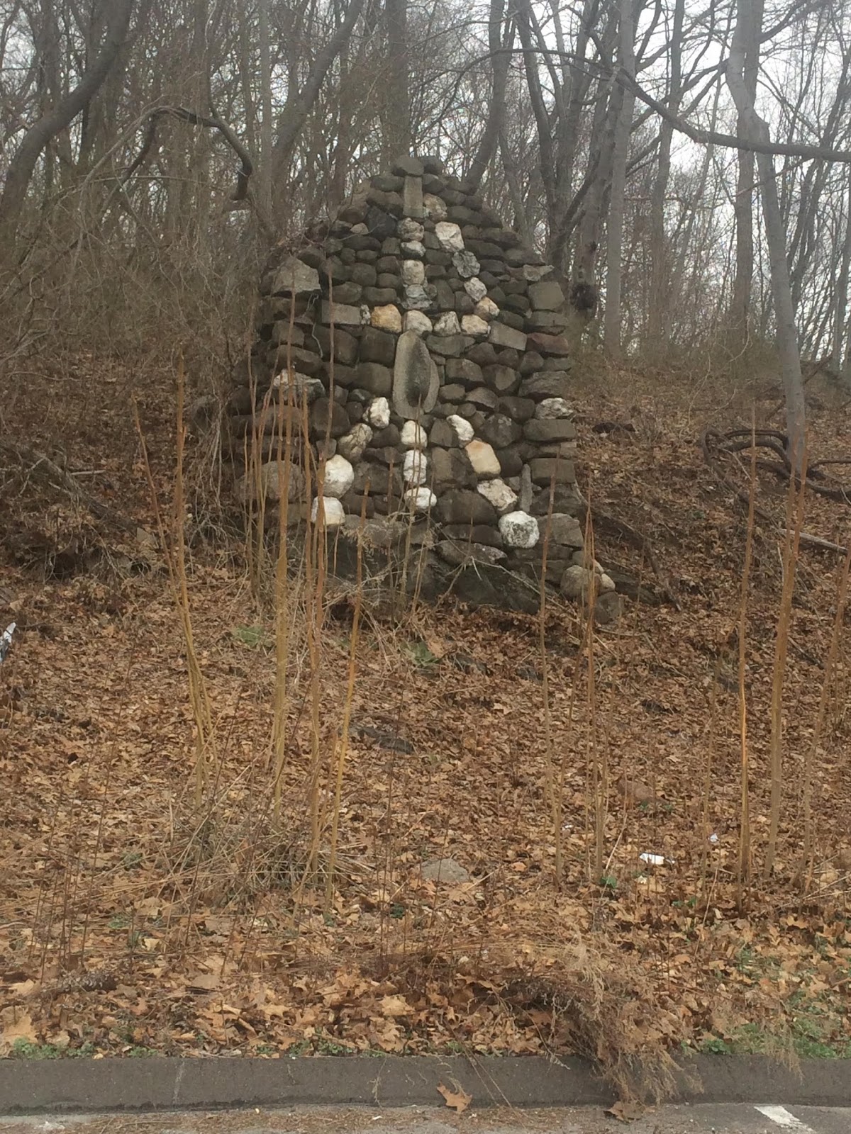
I am curious as to what the story is behind this rock pile in Woodbridge, CT. The location is at the corner of Schroeder Terrace and route 63. You can see the location on Google Maps at https://www.google.com/ maps/place/Woodbridge,+CT/@41. 344537,-72.985604,17z/data=! 4m2!3m1!1s0x89e7dbf9d23cf7df: 0xc3970065bcfa4cf0
I am curious as to what the story is behind this rock pile in Woodbridge, CT. The location is at the corner of Schroeder Terrace and route 63. You can see the location on Google Maps at https://www.google.com/
Any idea what this is all about?
Thanks!
STEVE F.Wednesday, July 22, 2015
More about the "new theory" of Native American arrival migration
It is not new and calling this a "theory" gives it credibility it does not deserve. Let's do a sanity check on the "new" results gotten by sampling volunteer DNA from Native Americans, Polynesians, and Siberians.
I cannot imagine them spending millions of dollars or spending years doing this study. Quite simply the could not have the time or the money to do proper statistics on this topic.
- Collecting personal data and some DNA, then running an adequate DNA sequence takes too long. (according to Wikipedia it is between 1/2 hour and 11 days for the sequencing)
- DNA sequencing costs too much > $1000.00 (according to this).
- There are 562 federally recognized tribes (this ignores Mexico and South America)
I cannot imagine them spending millions of dollars or spending years doing this study. Quite simply the could not have the time or the money to do proper statistics on this topic.
Uktena/Great Horned Serpents
There's a lot I'm pondering about Stone Uktenas, big and small, and Great Red Horned Serpents and the Three Tiered Worlds they travel through right now, waiting for the publication of a report that includes some Petrogylphs of the same that really tie in to what I'm thinking to really make it complete. So just for now, here's two pictures to compare, one from Peter in MA from 2008 and one from CT just yesterday:
Hint: Think of "Bison-like" horns" as PWAX pointed out in 2008 in MA and I didn't see until yesterday at the end of a row of stones at a place I've been a regular visitor to since the early 1970's in CT. Norman Muller, Peter and I also once stopped at this very spot for just a little while back in 1998, by the way, the sound of the Upper Falls mixing with the sound the wind makes in the trees...
Tuesday, July 21, 2015
There’s a New Theory About Native Americans’ Origins
Wow. Check this. Gotta rant.
Apparently the sampling was done with volunteer Native Americans, Polynesians, and Siberians - resulting in an inevitable conclusion: all Native Americans came during the one "wave" of migration.
I think somebody is naive and I hope it is not me. I am suspicious of their sample sizes, and am suspicious of how they sampled tribal diversity and did they "cherry-pick" the genome to get the desired result? And, by the way, it is not a "new" theory, it is the same old theory.
Apparently the sampling was done with volunteer Native Americans, Polynesians, and Siberians - resulting in an inevitable conclusion: all Native Americans came during the one "wave" of migration.
I think somebody is naive and I hope it is not me. I am suspicious of their sample sizes, and am suspicious of how they sampled tribal diversity and did they "cherry-pick" the genome to get the desired result? And, by the way, it is not a "new" theory, it is the same old theory.
Placement of Mounds (and More)
And by more, I mean "a lot more," some of which is similar to many ideas that come up on the Rock Piles Blog. I've subscribed to Todd's YouTube Channel and delved into the 100 plus videos there.
I've become a member here: Effigy Mounds Preservation Initiative
Monday, July 20, 2015
Sunday, July 19, 2015
Echo Lake Stone Chamber/ Lodge Research
From Matt Howes:
Hello folks,
My latest blog entry I have gone back to
the unique structure found by Echo Lake, examining the structure's
features, the history of the area, and other features which surround the
structure. Whether this structure itself is extremely old in it's
origin or goes back to the late 19th/ early 20th century I cannot tell,
as you will see from the blog entry. But one thing is for sure- this is
a very special structure located at a very special site location. It
deserves to be researched as an important site- if it is a more modern
structure than it seems it would be indicative of a small group of
Native people carrying on stone-building traditions into the late 19th/
early 20th century, in an area that would have been most significant to
the ancestors of local Native people, an area that was hurt badly by the
Milford Quarrying. However most of the features around the structure
seem to point to origins in a more remote past, it is just basically a
confounding feature about the stone lodge itself, as you will see in the
blog entry that throws the research of this site into a loop. However,
I have provided some possible explanations for this riddle, and it may
take a forensic geologist to actually get to the bottom of it.
This site should not be dismissed because of this one "confounding"
feature associated with the main structure itself. In short it deserves
the attention of being taken very seriously, and the site is just as
significant as any site that has a Stone Chamber/ unique structures,
etc. Here is the link to my research, my latest blog entry-
Have a good day,
-Matt
Saturday, July 18, 2015
Changing Conditions Link (CT)
Every Kind of Light & Revisiting a Site: Back to the
Standing Stone by the Path
(And following Norman's suggestion to brush away the pine needles...)
Friday, July 17, 2015
Pondering a Possible Panther (CT)
"No need to overlay any eyes or even a brow ridge
above them or highlight details of the snout and nose, there is a great degree of
possibility that this stone may well have been humanly enhanced – visible even
in this series of rather fuzzy photo images...Trying a sepia version suddenly changed this observers identification
of exactly what sort of animal effigy was being portrayed; this stone may more
closely resemble a Panther head rather than the Bear's head first suspected:"
Full version here: Pondering a Possible Panther Petroform at Pomperaug Plantation (Woodbury CT)
Tuesday, July 14, 2015
Road side attraction - Minuteman National Park
On Rt 2A, 100 yards east of Sunnyside you can glimpse some kind of rock pile in the woods off the south side of the road. It is about 20 yards in, not visible now when there is foliage. I had my camera in the car heading home from work and have been saving this.
It is a sort of "U" structure (opening to the upper right in the photo) connected to the end of a short loose wall. Here is another view:
And looking back along the "wall".
It is a sort of "U" structure (opening to the upper right in the photo) connected to the end of a short loose wall. Here is another view:
And looking back along the "wall".
This is next to a little wetland, perhaps the top of Elm Brook in Lincoln. It is something along these lines:
Lonely for rock piles....
...so here are some links
Mound Builders (of Indiana). Note the mounds at the spring leading to the Elhart River.
Mysteries in Stone (by Glen Kreisberg). Note the comments about circular "cyst" cairns. I think the "circular" versus "rectangular" is an important difference with what we see in MA.
Pretty picture. from here.(Iceland)
...gotta get back to work...
Mound Builders (of Indiana). Note the mounds at the spring leading to the Elhart River.
Mysteries in Stone (by Glen Kreisberg). Note the comments about circular "cyst" cairns. I think the "circular" versus "rectangular" is an important difference with what we see in MA.
Pretty picture. from here.(Iceland)
...gotta get back to work...
Sunday, July 12, 2015
Wednesday, July 08, 2015
Oneota burial cairn, northern Mississippi River valley
(From the Effigy Mounds Preservation Initiative Face Book
Group)
(Christopher Veit Photo)
Kurt Sampson (writes): “What is really known of these rock
"cairns" ?? Has one ever been excavated or explored to determine
this?”
Michelle Birnbaum: “Talk to Ron Schirmer - he has a grad
student working his dissertation on cairns near Red Wing.”
Kurt Sampson “That's where this photo came from. Christopher
Veit, what's the deal with these???
Michelle Birnbaum: They are not burials. Near Red Wing they
are one hill tops and may be group or territorial marker.”
Jimmy Clark: Seems we saw a few during the Great River Road
Survey with John Penman in 1981-82 while locating mounds and sites. Check
annual highway archaeology reports 1980 and after. And look through Orr's stack
of field notes. The bluffs weren't wooded until cessation of fires.
Ron Schirmer: “There are a few different types of rock-based
monuments. This particular one is a form apparently unique to Red Wing.”
Christopher Veit: “This monument is not visible from the
valley floor, and not because of the trees. It is hidden from view from they
valley floor by the crest of the slope, I doubt that was coincidental. I do not
belive this monument's primary purpose is as a territorial marker. I'll kindly
defer to Dr. Ron Schirmer in this matter.”
Ron Schirmer (responds): “Now I'm on a computer and can
address this further. The pictured monument is the only one that remains
unmolested. Originally it was a hollow structure, but it has collapsed. All
other known examples of this type were pulled apart between 1840 and 1880 to
look for "Indian relics". Single wooden posts (one of eastern red
cedar and one of oak) were found in separate ones, and one yielded "a
shank bone" without further description. None have ever been scientifically
studied. They are definitely not for burials, though they are clearly sacred
structures. When standing, they would have varied between 6 and 8 feet tall,
making them visible from the villages on the adjacent valley floors. And
indeed, a viewshed analysis shows that almost all of this particular type of
structure were within clear lines of sight of each other, and very much
clustered around a series of Oneota villages in the Spring Creek valley. Two
weeks ago I got the first AMS date from one of the villages - A.D. 1330.
Contrary to popular (and uninformed) belief, Red Wing was NOT abandoned after
the Silvernale phase, but instead continued to host a large population of
Bartron phase Oneota peoples well into the 14th century, contemporary with the early
parts of both the LaCrosse and Blue Earth Oneota regions.”
Todd J Stein: “Interesting - I wonder if these stone cairns
are related in function to the "ghost" or "spirit" houses
created out of wood by the Odawa people in Northern lower Michigan. They looked
very much like copies of longhouses (although they were constructed out of any
old wood or boards washed up on shore) with a peaked roof over the entrance on
one end. In height and length they looked to be about the size of a man,
although no burials or remains were associated with them. Up until a few years
ago there was a large number of them on North Manitou Island. When last I saw
them most were decayed &/or in a state of serious disrepair, although a few
of them seem to have been maintained until fairly recently.”
Ron Schirmer: “Interestingly, Todd, they do seem to be
related to Ioway tradition spirit lodges, which I would assume to be
functionally equivalent.”
Kurt Sampson on mounds in the Sacred Ground Documentary
Series:
Sunday, July 05, 2015
Curious Monuments of the Simplest Kind (Cape Cod MA)
"Curious Monuments of the Simplest Kind: Shell Midden Archaeology in Massachusetts" (2014).
Doctoral Dissertations 2014-current. Paper 12
Excerpts here:Curious Monuments
The Entire Paper:
Pocumtuck Homelands Festival News and Needs
From the Nolumbeka Project:
Four weeks from tonight we will be renewed and sustained by our memories of another meaningful Pocumtuck Homelands Festival. We are very excited and feel extremely blessed to have the honor to promote this special celebration of Native American music, art, and culture. Of particular good fortune is that this year the Turners Falls RiverCulture is co-sponsoring the festival with the Nolumbeka Project and helping us along in many many ways.
Our
publicity is in the works and will be out in full force within a week
and a half. We have added a few elements to the day, including the
presence of experts to help people identify and understand artifacts
and stone structures they found left by the early indigenous culture and
contact period colonials. Attached is a description this exciting new
aspect. Joe Graveline, David Brule and Howard Clark will repeat,
condensed (30 minutes), their well-attended presentations about the
significance of Great Falls/Peskeompskut- Wissatinnewag to the
natives and how the May 1676 massacre was such s dramatic turning point
of the King Philip's War.. Many of the wonderful vendors from last year
are returning plus a few more. And Ray and Wanda Stemple will be
serving up Native American fare from their "Now and Then" concession.
And,
especially, we so look forward to the energy and inspiration brought to
our spirits by special guest musicians: Joseph FireCrow, the Black Hawk
Singers, the Medicine Mammal Singers, and the Visioning B.E.A.R.
Singers.
We can use some help that day, if
you're available. I will attach a copy of our volunteer needs list.
Fortunately we now have pick up trucks available for both trips of the
risers, but we need strong people available at both ends and times to
load them, unload them, set them up, and load them again.
Also,
we are still trying to figure a way to move items from the vendor's
cars to their spaces. We cannot drive or park on the grass. If we do so
and cause any rut or damage we could lose the privilege of using the
beautiful park. We're hoping there are a few people with large garden
carts who would trust us to borrow them for that one day.
Even
if you don't have the time to help, please tell your friends this is
happening. We hope you can make it, too. It will be an uplifting day.
Diane Dix, for the Nolumbeka Project
Saturday, July 04, 2015
Wednesday, July 01, 2015
Subtle little alignment
From the same Gumpas area.
Follow the line of sight: from a pile in the foreground, between a pair of rocks, over a small surface rock, and on to a place where, luckily, the light makes the stone wall visible.
Subscribe to:
Posts
(
Atom
)