Tuesday, March 13, 2007

The anatomy of a marker pile site - a hypothesis

Some marker pile sites are organized with piles positioned along lines which radiate from one or more viewing positions. Often the viewing position is at a hight point and the rock piles are scattered downhill from there. Thus, in the abstract, we have something like this, with red dots for viewing positions and black dots for rock piles:
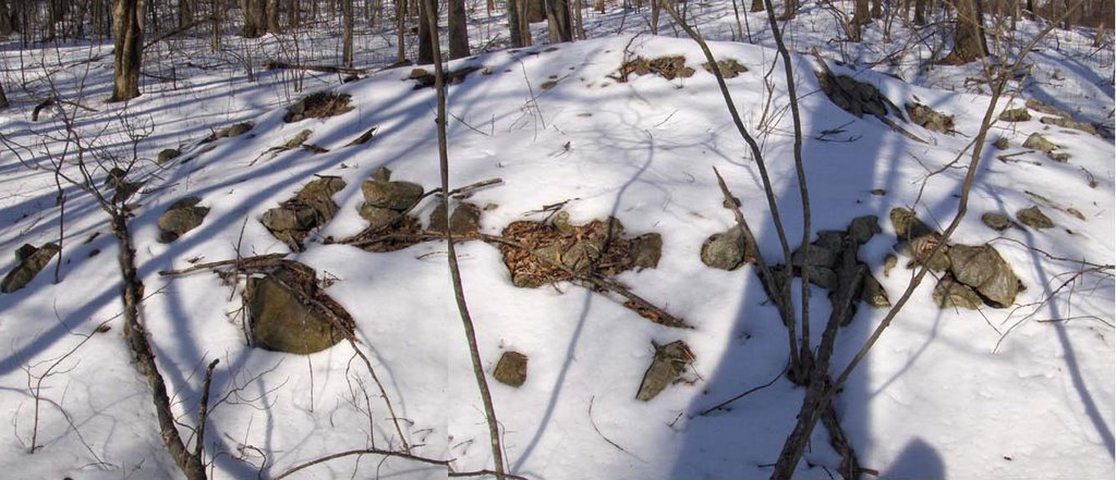
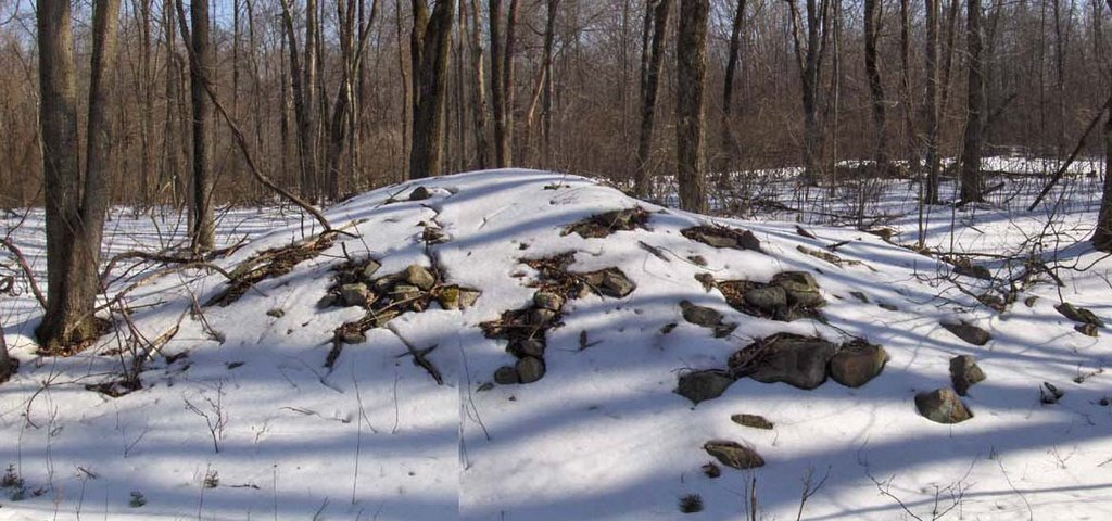
This is a sketch of a site I found this weekend and I am sorry I did not explore that third bump. Note how most of the piles are to one side of the viewing position but with some outliers.

The best documented example of a grid site, which I consider an example of a marker pile site, is the one we surveyed at Spring Hill in Acton, MA
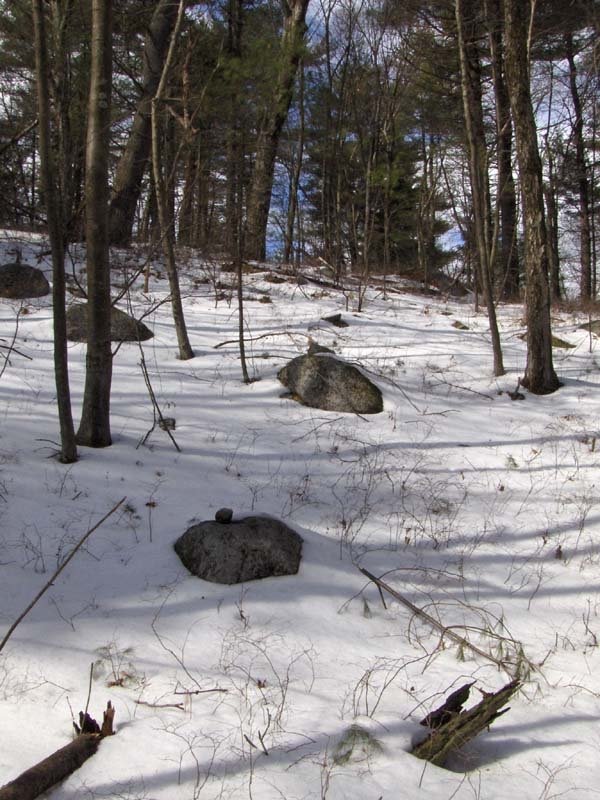
We can look at this with fresh eyes and observe the nearly horizontal lines converging to the right. There is a hight point in that direction but I do not know if it lines up. There also might be high points in the other directions indicated by the families of parallel lines in the diagram.

Ted Timreck's film getting out.

Dyson College of Arts and Sciences
Wednesday, March 14, 2007 7:00 PM
Native Voices - Hidden Landscapes WESPAC Foundation and Pace University Presents Native Voices. An Indigenous Film and Lecture SeriesCo-sponsored by Dyson College of Arts and Sciences. A documentary about sacred sites on the land we call our home, followed by discussion with director Ted Timreck and Professor Evan Pritchard (Micmac) of Marist College.

Larry Harrop explores a site Jim P spotted with aerial photos

Larry writes in:

About a year ago Jim Porter posted on your blog 3 screen captures from
Google Maps.

The post can be found here.
[Click here]

I finally found a way in Sunday and did some exploring. It's a very large and unusual site. All those lines on the map are indeed stone walls with more walls that didn't show up on the map. This is a large area of walls and rock piles. 90% of these walls don't seem to provide any agricultural purposes. There is also the remains of a colonial farm complete with a well, foundation and a small chamber and field walls.These walls are completely different from the ones at the wall sites.

The pictures from this site can be found here
http://larryharrop.com/v/stonington/

Finding Rock Piles From Space

by JimP
Back in May of 2006 I made a post to this blog called, "Exploring From 2,700 Miles Away." Basically, I discovered an interesting area of stone walls using Google Earth satellite imagery. Knowing the area as I do, I was positive someone would find rock piles there. The request went out and Larry Harrop answered the call. [Click Here] to see my post from last year.

After making multiple attempts to access the area over the past 10 months with no success (it is remote, surrounded by wetlands, overgrown with Mountain Laurel, and cut off by private land) Larry was undaunted. He finally had success reaching it this past weekend.

So could rock piles be found there? Did I actually locate a new rock pile site from 2,700 miles away? You betcha![Click Here] to access Larry's full gallery of photos from this new area. Keep an eye out for more photos from this site in the future -- Larry tells me he was able to explore only a fraction of this area the first time around.

Great work Larry, and thanks for following my hunch!

Monday, March 12, 2007

Ashland Knoll site: Odds and Ends and dating - part 2A

Here is a striking rock pile. Simple, impossible to see as farming related. This location, on a knoll in the middle of a rocky wet swampy area, is far from any plowable fields. And look at that arrangement.

While I am continuing discussing the "Ashland Knoll" site, let me mention that there were a number of outlines on the ground made from rocks. To me, these suggest more viewing locations or "seats"
They look to have been relatively recent - these component rocks are not covered with much lichen. And mixed in with one was this bit of green plastic table cloth: This reminds me of something from the fifties, or perhaps a little earlier. And it makes me think the site is not too old. Perhaps 60 years or so. Combined with a measure of the amount of pile damage, this creates the possibility of calibrating rock pile half-life [Click here] - which I go on and on about. Here is a typical pile:So there is something to go on. But lets not focus on that here. A point to make, relative to the green plastic table cloth, is that this site was in use relatively recently.

A knoll rock pile sites in Ashland, MA - part 2

As I approached this knoll I could see there was something interesting about to appear. I took a number of pictures here and in the vicinity; including rock piles with one quartz "blaze", and some others which were interesting to me. Here are some "blazed piles"
Here is another and a detail:
And another, with detail:
I am going to be claiming that these blazed piles are a type of marker pile and that the knoll is a marker pile site. Here was something very significant: all the piles were visible from the top of the knoll and the ones further down the slope were larger, as if to ensure their visibility from the top. This video, although I am a bit confused about the directions I am reporting, is critical:


See how everything is visible from the top? So this now becomes a hypothesis about marker pile sites: the piles are placed so as to be viewed from a point above. This is an important idea and I have more to report because it was nicely exemplified again later in the weekend.

Some sites in Ashland, MA - part 1

I went south of the Mass Pike to explore, hoping to avoid snow. This took me to Ashland, MA. Instead the crust was just slicker than usual. I had barely stepped into the woods, when I saw a large mound of some sort and was very happy to see it was a large rock pile:Here is another view: This a bit reminiscent of the large "roadside attraction" in Harvard, which I illustrated a couple of weeks ago [Click here]. They certainly look similar in the snow. But this 'mound' has what appears to be damaged structure, which you can see a little in this photo: Perhaps there was an inner 'cist'. This is a little different from the pile in Harvard. Also unlike other large piles I have found, which often are isolated, here there seemed to be a few other structures nearby. This looked a bit like the remnants of a viewing location or "seat":But check out the rock it is sitting on:Look closely. That is quartz and not snow on the rock. Really impressive up close. And also nearby, the hint of another pile. Seen closeup, I wish this was cleaned off a bit: Later in my walk I found smaller, more typical, rock piles. These initial larger 'mounds" could be outlying features of the same site, or could represent work of a different culture. I don't know how to tell; just that these big piles are different.

Also nearby, a pretty little stone lined spring. As usual, the piles are near where water comes out of the ground.
After this I explored outward from this site. In a couple of places I saw other isolated rock piles. I also explored around a prominent knoll. With this tree growing near the top of it, I am confident this was a place where people looked out over the scenery.
There were a number of prominent outcrop/knolls visible from this first one. So I was wondering if possibly the big 'mound' would be visible from here and whether it was substituting for a natural outcrop - filling in a gap in the 360 degree view from this spot. Now, pay close attention because that is a thought that gets echo'ed over and over during the weekend, which I will try to describe in part 2.

Sunday, March 11, 2007

More mystery tracks in the snow

Not rock pile related - but the sort of thing you see while out looking for rock piles in the snow. Any guesses?
Since these have melted a lot it probably could be anything. Note the size of my Bic cigarette lighter. I showed the pics to my dad who thought they must be bobcat or lynx tracks. I figure it could just be a splay toed labrador retriever.

Saturday, March 10, 2007

Ashland Appetizer

A first time venturing south of the Mass Pike. Stay tuned.

Rocky Pond Community Forest in Northborough MA

I parked and walked in along a gully towards the pond which was, I think south or southwest. In the snow I could easily scan a number of rocks as I went in and I did soon see a rock-on-rock, and then several more, to my right on the western side of the gully.
They are pretty in the snow. At all times I am wondering if my legs will carry me further without tiring. But they held up. My eye was led upwards several times to the right. Here is one example of rock-on-rocks leading the eye upwards:
When I got to the pond I saw this:
I turned around and came back via the other side and then the first side of the gully. Again my eyes were drawn upwards:And this time I went up to look above and found other rock-on-rocks and this:
And a last rock-on-rock:
From first to last these rock-on-rocks and minor piles are scattered over one part of the hillside stretching from the higher shoulder down into the gully. The only reason I can imagine for this particular restricted location on the western slope of the gully is that there is a particular angle of view down the gully (perhaps to the northeast?) that is available only from this angle.

Friday, March 09, 2007

More on Nipsachuck - the North Smithfield RI site threatened by development

[Click here]
This is from "The Call" in an article by staff writer Joseph P. Nadeau entitled "Sekonke Wampanoag chief visits stone site." Thanks Bruce McA. for the link.

I want to make some comments.
  • Note that the Sekonke Wampanoags are not clear about what the stone piles are. Nor do they appear to be aware of the large number of sites in all parts of New England.
  • Note that every expectation should be that archeologists dismisses the stone piles, in spite of "feelings" that they are Native American. Meli, on the other hand, can be expected to be aware of some of the work done, and being done, on rock piles.
  • Note the hypothesis that these are graves. From the sounds of it, they are more likely memorial piles than graves. Unfortunately, who will make an alternate hypothesis?
  • Note another important King Phillip's War battle site is called "King Phillip's Woods" in Sudbury - has many rock piles including large numbers of rock-on-rock which are obviously not graves.
  • Note numerous statements from Indians about this probably being a burial area.
I am happy to see that rock piles are moving more to the "frontal cortex" of both European and Indian awareness about New England's historic past. I hope that pretty soon, say in five or ten years, it is going to be much more common knowledge.

Thursday, March 08, 2007

Rhode Island piles from reader Tim M.

He asked me to not say where these are from. The pictures include some interesting small structures.

This is a standing stone , grown into a tree, with a small piece of quartz-like material on the ground a foot in front of it. Given how the quartz is placed with relation to the leaves, it looks like it must have been placed there not too long ago.

This looks to be two examples of short linear arrangements of rocks ending in a small triangular standing stone.Some supported piles with a small number of upper rocks:

Fish Weirs

Norman Muller writes in:

This is a fine paper on fish weirs:

http://www.lutins.org/thesis.html

Update: Tim MacSweeney writes in comments:
Here's another link to it; and it says:"Welcome to the only official homepage for a: Native American Fishing Weir in the Passaic River of Bergen and Passaic Counties, New Jersey http://www.bergen.org/AAST/Projects/Weir/

Wednesday, March 07, 2007

Rock piles and holly trees

The American Holly is a favorite tree, native to southern Mass.They were mixed in with the white pines at Bruce's Lakeville site.

Some outcrops with rock piles - more from Lakeville MA

Bruce pointed out that at this site there are many places where the rock piles seem to be incorporated into outcrops. This first one is at the edge of a level spot with maybe five rock piles on it.
Here are some:Here is another outcrop with structures on it. This one was right next to those short stretches of wall (click here)
The whole place was complex and structured. It seemed very broken down but also un-disturbed.

Lakeville rock-on-rock

Some more scenes from Bruce McAleer's Lakeville site

A beautiful split wedged rock.What I interpret as quarry marks: A pile in the sun:A pair of quartz fragements on a rock next to the trail. They had some debris buildup around them.In case you miss New England: