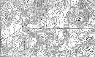
 I had already found a number of rock pile sites at the time I started looking for the sites Mavor mapped and, interestingly, I only found one of the sites he mapped and he never found any of the other sites I had mapped. We followed different search strategies in a pretty limited area of conservation lands - around "Long Pond", north and south of Brick Kiln Rd, north and south of Thomas Landers Rd. He followed alignment directions, along stone walls or surveyed outward from some key location. By contrast, I just looked for kettle holes and places where hill meets water. Apparently it does not matter which strategy you follow - there are enough sites to go around. Also worth mentioning is that you do not see these piles from a distance but have to be actually stepping on them to see them in the lowbush blueberries. There are probably several good sites still to be found but I have exhausted all the obvious places to look.
 Last week I was out trying to find some of the "dots" on one of Mavor's maps and, instead stumbled into a whole new site. In the end it turned out this new site was part of one Mavor did find and I was simply mis-interpreting his map. At any rate I found this site by being persistent and slogging up over one more hill and pushing through one more quarter mile of blueberry bushes.
 These pictures give an idea of the light under the leaves and how the piles are hidden in there. Typically these piles occur in little clusters, as shown on the map fragment above.
Look at the light:
 This is a pile that was cleaned off by someone - not me.
An example of just how buried and hard to see these piles are. Sometimes you find them only when you happen to step on one and detect loose rocks under foot.
 Walking along exploring the slope, I found this pile which is very clearly designed to support the pointer rock.
 Examples like this re-enforce the idea that these piles were originally meant to be seen from a distance - I suppose back when this was open pasture, namely any time before the last 50 years. All of northern Falmouth used to be open. Now it is all trees and blueberries.
 I went out twice since then looking for more rock piles but nary a one was found.
 A final comment about Mavor's search strategy. Note the diagonal straight line cutting through the upper rock pile cluster on his map. This is a winter solstice sunset line that leads out towards something like Cuttyhunk, starting from a very prominent glacial erratic he called "Indian Rock". Apparently Mavor walked along this line finding rock piles and confirming his hypothesis that the piles served to mark that line. But there are plenty of piles and sites not along this line and I believe these piles are placed for positioning over a much shorter range - that the viewing position is not some large and distant boulder but somewhere closer to hand. That first photo above looks like it might have been a viewing position. So there is a lot more to be understood here beyond a single solstice line.
No comments :
Post a Comment