 Since I have been exploring in the "Shaker" parts of northeastern Harvard, I looked up what Mavor and Dix had to say about the area. On p.290 of Manitou they write about a number of features on what they call "Mount Zion" and show a little map which corresponds with the north-south-elongated hill on the right side of the above map fragment. This area is a Harvard Conservation land with a parking lot on the north side of South Shaker Rd. So I parked there, examined the trailhead map and then set out. Apparently I headed in a slightly wrong direction cuz the hill I explored had none of the features they described. I still cannot figure it out because it is as if I was on the little hill to the left up and to the right of the word "SHAKER" on the map.
Anyway, I did find some minor piles and other things, whichever hill I was on. Starting a few feet in from the trailhead, on the left, there was a pile with an unbroken cream/milk bottle at its center:
 And then I found a number of examples where colonial or farm related items were placed within the rocks. With apologies about the poor photo quality, here is a split "wedged" rock incorporating a folded rusty piece of iron.
 When I saw this I thought "Hmm, Shakers.....the first wannabes". I was getting the feel of white people running around pretending to be Indians but doing it in a ham-fisted way. It seemed like every other split rock was wedged with one or another piece of farm related junk. Continuing with this line of fantasy, I imagined the real Indian shamans being only too willing to take advantage of rich translanted Europeans playing at Indian spirituality.
As I edged up the hill, following a "Yellow Spot" trail, there was no sign of what M&D call a "Cleared and levelled area" and I did not find the other things at the hilltop which they described. Instead I found a large tumbled down pile on the north western side of the summit.
 Then coming back south at what I think was the high point there was this little circular pile:
 Probably the most substantial rock piling I saw was a little shrine type thing in the woods: a couple of rock piles near a stone wall at the eastern base of the hill, with a short line of steps leading part way up the hillside:
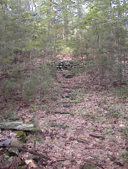 At the top was a 10x15 foot level spot with a back wall made as a nice rock pile:
 I continued having a slightly negative reaction to these out-of-place non-Indian features.
 Aside from a few other minor low ground piles downhill from the path on the eastern slope of the hill, this was all I saw. So I went back to the parking area, crossed to the south side of S. Shaker Rd. and continued exploring over there.

2 comments :
A easier and shorter way to find Holy Hill is to go in the entrance on Ann Lee Rd. There is a Conservation sign but no parking; it is on the east side of the road about halfway between South Shaker Rd and Babbitt Lane. Just a hundred yards or so in, the trail goes uphill to your right and brings you to the Holy Hill of Zion.
Sue
Thanks Sue. I wonder which hill I was on?
Post a Comment