Manana Island is located ten miles off the coast of south central Maine next to Monhegan Island. Manana is the smaller of the two islands and is located on the west of Monhegan. Manana Island can not be discussed without a brief look at what took place on Monhegan Island. Long before the Europeans first set up a fishing station in the 1600’s on the island local Native Americans had done likewise.

Fig. 1 - USGS Map of Manana and Monhegan Islands
Monhegan Island
I walked over this island from end to end but did not have time to walk every trail. No cairns were found on it. The museum which I also missed visiting has a collection of Native American artifacts on display that were collected on the island. A letter from the island’s historical society stated that Arthur Speiss the Maine State Archaeologist had seen the collection and gave them a brief synopsis.
1. Bifircate Base Point – Early Archaic 8,000 years ago
2. Felsite Point – Moorhead Phase (Archaic)
3. Barbed Bone Spear, a Bone Awl, a Ground Beaver Incisor, many Sinkers, Abrasive Stones, Slate Spear Point fragments, Gouges, Axes, Scrappers, Choppers, Shaft Abraders, Hammerstones, Grindstones, and a Susquehannah Broad Point – Late to Transitional Archaic 3,400 years ago
4. Side Felsite Point – Ceramic Period 1,000 to 1,200 years ago
“From all recorded accounts, archaeologists believe the island was used as a seasonal base during the late summer and autumn months while the codfish and swordfish were abundant, about 3,000 to 4,000 years ago.” This statement was from Tracie Bracy, curator of the Monhegan Historical & Cultural Museum (Letter: Sept. 25, 2002). It reflects the bulk of the Native American artifacts that date to the Late to Transitional Archaic Period. It does not take into account the Early Archaic and Middle Ceramic period which are poorly represented but none the less represented showing the Native Americans went out to the island before and after the main fishing period.
In the book Monhegan The Cradle of New England by Ida Sedgwick Proper (1930) she stated “that there were numerous Indians quartered [camped] on the Island [Monhegan] is recorded by Gorges in his Briefe Relation, among whom was undoubtedly Samoset.” (page 136). Gorges was in the area in the early 1600’s. In turn, this places Native Americans on Monhegan in the Late Ceramic / Proto-Historic Period.
Native Americans went out to Monhegan Island. Manana Island is a short row boat ride across the harbor from Monhegan Island.
Manana Island
In September of 2002 I made a visit to Manana Island to see the petroglyph [click here for related article] which I wrote an article on that was published in the Maine Archaeological Bulletin Vol. 44, Spring 2004 (see website for copy of article). While there I found the island was covered with cairns.
The island is ¾’s of a mile long by ½ mile wide. Its length is oriented approximately north – south and width east – west. The island is a rounded knoll with a raised outcrop on the west side and a slightly raised north end. On the west side (open ocean side) there is a natural wide gulley paralleling the north end. On a flat short ledge above the gulley is the petroglyph. The island is covered with long grass and short brushes around the edges. A spring located in the middle of the west side was stone lined and shaped into a rectangular pool.
The island has several buildings. One is an abandoned 1960’s house on the east side. On the west side the Coast Guard built several buildings. The house, a storage shed, and fog horn building are still standing. In addition there is the long boat rail/launch on the east side which has been turned into a raised wooden walkway for visitors. In the gulley area near the Coast Guard buildings there are several piles of stone with rubbish mostly an assortment rusted metal parts presumably from the Coast Guard era. Some of these stone piles are on exposed bedrock surfaces and may be cairns.
Two Cairn Fields
Geographically there is the short raised north end, and the long undulating middle section / south end. On the north end there is a small quantity of small cairns. Cairn designs found here are On Top of Stone and Split Stone. The On Top of Stone cairns each have a few stones that do not cover the whole base stone. Plus, not all the exposed bedrock surfaces and boulders have cairns. The petroglyph is on a ledge face on the north end. It faces south and is beside the gulley which is angled southwest out to the open ocean. Anyone visiting the island may want to take a compass reading along the face of the petroglyph to access a possible sunset alignment.
The middle section / southeastern end form the second section. The section is denoted by the cairn with the large triangular slab leaning against it. The cairn is on the south side of the boat rail/launch. To the north of the cairn on the other side of the boat launch note there are a few exposed areas of bedrock among the grass that do not have cairns. This forms a dividing line between the two areas. Starting at the cairn with the triangular stone all exposed bedrock which look like in-ground boulders level with the ground’s surface contain a cairn for as far as you can see. I estimated between 50 and 75 cairns but did not have time to make a count. This pattern continues until you reach the southwestern corner of the island. There the cairns are scattered among numerous exposed bedrock surfaces without cairns. Cairn designs in the middle section / southeastern end On Top of Stone, One Stone on Top, Split Stone and Leaning Against Boulder. The striking characteristic of the On Top of Stone cairns in this section is each cairn completely covers the base stone it is on. The cairns range from large (10’L) to medium (7’- 4’L) to small (2’-3’). Short rows of boulders abutting each other 7’L x 2’W on the ground may be features. On the east side of the island near the water’s edge (field notes) and near the 1960’s house (? memory) there is a wire fence enclosed circular feature and an enclosure. The circular feature looked like the top of a well shaft but it only had a single layer of stone which made it unsuitable for a well. Above ground it was 2’H x 1’W x 3’Dia. (interior) and was ½ filled with stones. Ten feet away was a U shaped enclosure. The enclosure opened to 320 degrees NW. It had a few scattered stones inside. Size: Interior 3’L x 2’W. A couple of cairns were located below these structures at the waters edge.
 Fig. 2 - Sketch Map of Manana Island showing location of cairns and other structures
Occupants on Manana Island
1. The Coast Guard built a fog signal station on the island in 1855 which was staffed until the 1980’s.
2. Ray Eugene Phillips lived as a hermit on Manana from 1930 to 1975 and maintained a flock of sheep there.
3. In the 1960’s a hippy and his family built the house on the east side and lived on the island for a couple of years.
Analysis of the Cairns
The cairns are divided into two distinctly different types of cairn fields. The north cairn field has a small quantity of small cairns and the petroglyph. The middle/south cairn field has a large quantity of large cairns, a cairn with a triangular standing stone, a spring, an enclosure and a circular structure. The basic differences in the cairn fields preclude that any of the Euro-American occupants built the cairns. If an island resident like Mr. Phillips who maintained sheep on the island had built the cairns he would not have made the distinction between the small scattered cairns on the north end and the large cairns on every exposed bedrock surface on the middle/southeast section. Furthermore, the petroglyph which has been identified as Native American and the enclosure must be taken into consideration. The integrating of the petroglyph and enclosure into their respective cairn fields along with the differences in the On Top of Stone cairns, the triangular stone leaning against the cairn and the additional cairn designs indicates the cairns were built by Native Americans for ceremonial purposes. The small cairn field on the north end can be interpreted as a shaman area where one or two people went for a specialized ceremony. The large cairn field on the middle section / south end can be interpreted as a community area where a group of people gathered for the main ceremony.
Fig. 3 On top of boulder cairn with triangle standing stone

Fig. 4 - Column like cairn

Fig. 5 - Overall view showing the middle / south cairn field

Fig. 6 Elongated cairn on stone


Fig. 8 - More elongated cairns
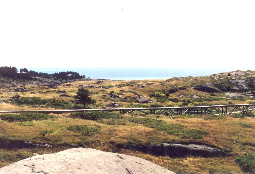
Fig. 9 - View of north cairn field

19 comments :
A great smoking gun on the nonsense of "field clearing".
Too bad Bing or Google maps don't give high resolution of this island, since it is so open. If we had, we would probably be able to see and count the cairns on the ground.
Sorry but the premise that these cairns were constructed by early Native Americans incorrect.
Ray Phillips piled the rocks to clear land for his sheep, often with the help of another islander, Henley Day. The rocks were piled on ledge to leave more space for grass to grow in the shallow soils on the island. This I know because I saw them moving the rocks into piles when I was a child. Also I was one of the "Hippy family" that lived on Manana for 4 years (we moved into Ray Phillip's shacks in 1976) so I am very familiar with the local lore regarding this.
If you had asked the older locals on Monhegan you would have been set straight as it certainly was no secret.
Nice idea though ;-).
Dear Amy,
We apologize for the use of the reference "hippie family", it the term that the Islanders used in reference to your family. We will corrected this in all future discussions of the Island. Please let us know your preferred name. Mary did make inquiries of some of islanders and the museum concerning Manana's history. Ray's rock pile building activities were never mentioned. We are curious as to how old you were when you participated in adding stones to the piles? We are also interested in knowing how many sheep Ray normally had on the island. When did your family move to the Island?
It is clear from your recollection that Ray did add to or create some of the piles. However, extrapolating from this small piece information to the conclusion he was responsible for ALL of the rockpiles requires a giant leap of faith in the data.
Ray lived on Manana for 45 years. One could reasonable expect that he would have cleared the entire island of stones to maximize grazing. The southwestern section of the island is devoid of any rock piles. This absence requires some logical explanation if indeed all of the piles are simply field clearing. Second, there stylistic differences between the piles in the northern cairn group and those in the middle/southern group. This likewise, requires a logical explanation if indeed all of them are field clearing.
I think this question could be resolved if some pre-1930 photographs showing the middle and north sections were located. If the photos showed no cairns then the field clearing hypothesis would be proven. If the photos do show some cairns then the case that Ray did NOT build all of them is proven.
We have a number of other questions about Manana Island which we would like to ask you. Please feel free to contact us privately.
If anyone has pre-1930s photographs we would like to hear from you.
James Gage
www,StoneStructures.org
info@stonestructures.org
If the sheep herding story is complete, this is a disappointment - a great example of an undisturbed site, thrown into doubt.
But I want to support James in questioning details of the account. Although it is hard to argue with "eye witness", we may not be getting a complete story. For example who was Henley Day? Practical uses and ceremonial uses are not necessarily opposites.
More research needs to be done on this site before it is accepted or rejected as ancient or modern. The pointed standing stone in front of that one cairn (figures 3 and 4 are of the same cairn, by the way) looked pretty convincing to me of an ancient construction, but obviously someone needs to examine the patination on the exposed surface of the stones and then see what there is underneath.
In his book Merlin And The Discovery of Avalon In The New World, Graham Phillips argues that standing stones on Manana Island could mark the grave of the historical Merlin. The book also discusses the Newport Tower and approx. eighty cairns on West Hill near Rochester, VT
From this eye witness we can conclude that rock piles were being built or at least maintained in living memory. But we cannot take the explanation of motives at face value and without question.
The witness might have been young at the time, and might be filling in gaps in the observations with factoids from the local mythology. In general, whenever rock piles are visible and obvious to the public there is a local mythology about the piles. People have to have an explanation and what one person makes up the next person may consider to be a well-established fact.
Ray Phillips, the Hermit of Manana, was not an industrious or ambitious man according 1970's newspaper interviews with him and others who knew him. Photographs of his shack on Manana (available on http://thehermitofmanana.com website [scattered across several different pages]) show loose stones around his shack which were never placed in piles. furthermore, Ray Phillips used the least possible number of stone to support his foundation. If he was truly interested in getting rid of stones, he would have made a much more extensive stone foundation. It would have been a simply but effective means to get rid of stones. He did not do this nor did he gather the stones around his shack.
Norman Muller has pointed out to me that the cairns have heavy lichen cover and extensive weathering, generally a good indicator of significant age for the stone structures.
The physical evidence on the island and details of story of Ray Phillips piling rocks are not consistent with each other. These inconsistencies warrant further investigation. Mary's argument that cairns are Native American remains a viable alternative explanation.
James Gage
www.StoneStructures.org
daniel says: the comment by "AMY" is accurate and to dismiss he as young or uninformed, because she doesn't support your mild obsession, is dissmissive of all scientific investigation. This isn't about belief, it is about reality and we don't "vote" on reality.
I lived on manana when amy did and I still do. Ray phillips did indeed pile many of those rocks, and Henley day did, indeed pile most of them. We all watched them do it! Some others did as well for a few decades earlier, according to Henley who is also now deceased.
I piled many myself and continue to do so, although we get not nearly the frost heaved crop each year that an inshore farmer would, as the diorite first has to spall off the bedrock before it can heave up through the sod. Piling up rocks is about the ONLY thing that is easy on Manana, and contrary to one of the discussion statements, it doesn't take so very long. And lichens take years to grow, but not centuries by any stretch. Just turn over a rock and sit back...it'll come.
The so called petroglyph was made by the last glacier as it receded 10000 years ago, not by algonquins, or norsemen, or celts, or phonecians, as suggested. The romance of those interpretations is seductive to us all, but the scratches were investigated by people who really wanted them to be artifact and they had to admit they are a natural formation.
Most of the cairns in the photo were made by me in an effort to bury my rubbish back when the island revised its trash procedures. One such cairn covers a horse skeleton (his name was simon) another (picture 3 and 4)is full of broken glass and cans. The little cairns on the north end of the island are built by summer visitors ( it became a real trend ten years ago) and are removed whenever I can get to them. I'm not destroying ancient remains, I'm trying to keep the cliff uncluttered with silly whimsy. There were NONE there twenty years ago.
I share your delight in history and speculation about the interactions, travels and cross cultural influences of various people throughout time. The real stories are as fascinating, when we learn them, as anything we can imagine that turns out not to be the case. Let's stick with the truth and discard that which is not. thanks......daniel from Manana
Paul said...
We have a wonderful print, marked 120/250, done by artist E. Rising that we bought back in the 70's. The image is an old man and a goose. The title is "Ray and Donald." On the back there is a newspaper clipping featuring a story of Raymond Eugene Phillips and his best friend...a goose named "Donald" who lived on Manana island. It reported that Ray... "For years he labored, piling rocks and adding fertilizer and clam shells to the shallow soil in order to have grass for his sheep."
Hi Daniel,
Thank you for sharing the information on your rock piling activities on Manana. We will certainly have to factor that into any future discussion of the island.
In regards to your theory about the glaciers being responsible for the petroglyph, I have a single question: The grooved lines are only within a narrow band of intrusive rock in the vertical rock face. The grooves do not extend beyond it into the parent bedrock. How could the glaciers only scratch this narrow band and not leave gouges on the rest of vertical rock face?
James Gage
www.stonestructures.org
Re Figure 8 "Elongated Cairns" - I'm sorry. There is something creepy about them. Each is a small outline with a bit of space in the middle. There are about 5 of them visible, all with this same structure. I have seen field clearing and this is not it. I do not doubt that later people were using the piles to get rid of rocks but that does not do a good job explaining the evidence of repeated designs.
Sorry, somewhere between 3 and 5
I also want to ask Daniel:were any piles already there when you built yours?
One way to solve this problem would be to search for pictures of the island from before anyone lived there... another would be (though I hesitate to say this) to go back to the island and have Daniel take you to all his rock stacks and have a look see...
Additionally, the petroglyph doesn't look like a natural marking, it does indeed look like a man made etching but anyone could have done that....
Could it have been Merlin Ambrosius, possibly, but we're looking at that being around 500ad and while I suppose it is possible... it seems sort of unlikely that it could or would even still be there...
I'm no expert, obviously, and I would love to believe that Merlin island hopped to Canada and walked to Maine and died on manana... but it's kind of difficult to tell anything for sure... someone needs to send an unbiased archeologist to have a look see... give us all some solid foundation before we jump to conclusions...
Along with a friend, I visited with Ray Phillips on Manana in 1969, and again in 1970. The so-called "hermit" was hospitable, and very talkative. He did have a flock of sheep. He was very fond of them, especially one he called Rosie. There was no sense whatsoever that Ray avoided work, and I'm confident that he would have done whatever was needed to nurture his flock.
My friend and I also visited the petroglyphs, which at the time we were told were Viking in origin. But, I've read convincing arguments that the petroglyphs were made by Native Americans, and not by glacial activity nor by Viking visitors. In all, the Island as we experienced it imparted sense of wonder; and our visits with Ray remain strong memories even now in 2023/
This is totally wrong. These are far older than your silly farmer and the story of him clearing fields. You guys have drank the koolaid when it comes to your true history.
Post a Comment