 Bruce McAleer had read about rock piles in a UMass forest-use report about Cadwell Memorial Forest and proposed we drive out to Pelham Mass, way out on the west side of Quabbin Reservoir, and try to locate some of the piles there. The season is perfect for it because it is easy to see through the woods without foliage. Bruce drove and I was spotting for rock piles out the car window and even as we drove west on Rt 2 I started seeing piles in the woods to the side. When we turned south onto Rt 202 around Athol Mass, we agreed that if I saw any more rock piles we could stop and take some pictures - all part of the field trip. So as we are in New Salem I saw one rock pile ("there's a rock pile!") and then another - looked like low platform piles in the woods. When we stopped and got out to explore it was an incredible site, as I'll describe in a subsequent post. But after that we drove on and, a minute or two later, saw another site, this one a more traditional marker pile site on the side of a hill. We agreed at this point that Rt 202 should get this year's Rock Pile Highway of the Year award. Later, we did explore the Cadwell Forest and saw three or four other rock pile sites, then we came home along Rt 202 and this time I was facing out the window towards the other side of the road and saw yet another rock pile site in New Salem.
Over and over Bruce and I agree that there are rock piles all over. Not just on the hills, nor just by the swamps, nor even along special alignments. They are simply everywhere. I think the question is why don't people see them, how could they go un-noticed? Perhaps most people don't get out much and those that do are used to ignoring anything that looks like a stone wall.
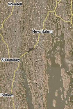
 Anyway back to Rt 202 and spotting rock piles. The first site was about a mile north of Moosehorn Rd, just north of the power lines mostly on the east side of the road. There would be a very fine view from here southeast into the valley which, today, contains the reservoir. Then the next site was a bit north of Cooleyville Rd on the southeast side of the road of 202. The third site I spotted, on the way home after we ran out of time and picture memory in my camera, was just south of Freeman Rd on the east side of the 202. I love these road names. I was saying "Moosehorn Road" for the rest of the day. I was worried I would not have any room left in my camera after Moosehorn and Cooleyville Rds. In fact I had used up about 28 of the 40 available.
So we got to Pelham Mass, went south on Packardville Rd and entered the Cadwell Memorial Forest at the first main entrance we saw. From there we walked straight in, northward, past cellar holes and rock piles for about a mile or so. Some of the pile we saw were not on the map. Then we curved around to the right, starting back south, saw a Civil War cemetery and missed seeing some of the mapped rock piles until we arrived back out on Packardville Rd and walked about 1/2 mile along it to get back to the car. I was so cautious about not using up remaining pictures that I still had 8 unused, so it was a good thing Bruce wanted to visit one last corner of the woods. We drove over there, took the 8 pictures, and then headed home.
I would like to describe some of the sites we saw, taking it a post at a time.

1 comment :
Post a Comment