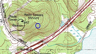
 Went for a short walk at lunch with a friend from work and found a small rock pile site. My workplace is between Rt 495 and the Merrimack River in Andover Mass and there is still a large chunk of woods in there. I have been exploring odds and ends and finding disappointingly few rock pile sites in these parts. Mostly, the woods seem not only raped but beaten and murdered too. Either the farmers around here were genuinely destructive or else the "hidden Indians" abandoned this part of the world before the farmers; so they never came back to heal some of the wounds. Anyway there are not many sites up here in Andover or else I have been unlucky. But today we did find a small site near the very top of the hill with the radio towers. This is a hill you can see for miles around, north of 495. We parked at the top, next to the access road to the highest tower and walked in, downhill southward, towards the highest tower. At its foot my friend indicated we should go down the trail to the right but, after a moment, I said I would prefer to go down to the left, because I could see a bit of a gully developing in that direction and I wanted to explore down in there. So we left the trail, walked into the trees, down into the gully, and right up to a small rock pile site. My friend knew we were looking for rock piles, and this made me seem to be a magician. This was a reward for my earlier disappointments.
 So we took a couple of pictures, and I tried to get a sense of how this site was situated: on a slightly sloping shoulder of the hill beside the gully, ~40 yards down from the tower. There were three piles I noticed. One was in decent repair and looked like a platform pile, with medium sized rocks, built directly at the edge of the gully and facing out over the southern view.
 One of the other piles was wrapped up in tree roots and the third was a little higher and smaller.
So the standard question: why here but not there? Clearly it has to do with the gully and, in fact, the first time running water was actually present was about at the same level as the site. But the gully starts higher on the hill and probably has more water during a wetter season. As we looked out at the southern sky towards hills across the valley, there was a noticable dip in the horizon, about level with us, off towards the southwest. (You can make this out through the trees in this photo, the gully is to the right and runs in the same south-southwesterly direction.)
 By coincidence, my friend had a compass on his watch and he estimated that the direction was ~210 degrees. Does this mean anything to you? At any rate, with the water and the view we have a possible answer to the question of why the site would be located here.
3 comments :
I am told that around here to convert from magnetic compass readings to true ones, employ the formula:
True = Magnetic - 15.5
I am also told that this compass reading, which converts to about 195 degrees, is more weserly than the winter solstic sunset.
Oops I meant westerly.
Post a Comment